Maps of Queens County
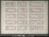
Manhattan, V. 4, Double Page Plate No. 71 [Map bounded by E. 32nd St., 2nd Ave., E. 27th St., 4th Ave.]
From Atlas 42.54. Vol. 4, 1890.
Manhattan, V. 4, Double Page Plate No. 71 [Map bounded by East 32nd St., 2nd Ave., East 27th st., 4th Ave.]
From Atlas 113. Vol. 4, 1899.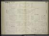
[Plate 79: Map bounded by East 32nd Street, Second Avenue, East 27th Street, Fourth Avenue.]
from Maps of the city of New York / surveyed under directions of insurance companies of said city.
Plate 71: Map bounded by East 32nd Street, Second Avenue, East 27th Street, Fourth Avenue
from Maps of the city of New York.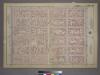
Plate 13, Part of Section 3: [Bounded by E. 32nd Street, Third Avenue, E. 26th Street and Fifth Avenue.]
from Atlas of the city of New York, borough of Manhattan. From actual surveys and official plans / by George W. and Walter S. Bromley.
Part of Section 3 : Plate 56.
from Atlas of the borough of Manhattan, city of New York.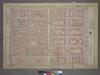
Plate 13, Part of Section 3: [Bounded by E. 32nd Street, Third Avenue, E. 26th Street, and Fifth Avenue.]
from Atlas of the city of New York, borough of Manhattan. From actual surveys and official plans / by George W. and Walter S. Bromley.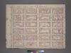
Plate 13, Part of Section 3: [Bounded by E. 32nd Street, Third Avenue, E. 26th Street and Fifth Avenue.]
from Atlas of the city of New York, borough of Manhattan. From actual surveys and official plans / by George W. and Walter S. Bromley.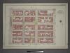
[Plate 14: Bounded by E, 127th Street, Second Avenue, E. 122nd Street and Park Avenue.]
from Atlas of the city of New York, borough of Manhattan / from actual surveys and official plans by George W. and Walter S. Bromley.
Part of Section 3 : Plate 57.
from Atlas of the borough of Manhattan, city of New York.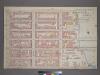
Plate 12, Part of Section 3: [Bounded by E. 32nd Street, (East River Piers) First Avenue, E. 26th Street and Third Avenue.]
from Atlas of the city of New York, borough of Manhattan. From actual surveys and official plans / by George W. and Walter S. Bromley.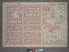
Plate 12, Part of Section 3: [Bounded by E. 32nd Street, (East River Piers) First Avenue, E. 26th Street and Third Avenue.]
from Atlas of the city of New York, borough of Manhattan. From actual surveys and official plans / by George W. and Walter S. Bromley.
[Plate 61: Bounded by E. 37th Street, Third Avenue, E. 32nd Street, and Fifth Avenue.]
from Atlas of the borough of Manhattan, city of New York.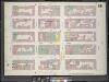
Manhattan, V. 4, Double Page Plate No. 68 [Map bounded by East 27th St., 2nd Ave., East 22nd St., 4th Ave.]
From Atlas 113. Vol. 4, 1899.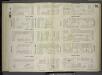
[Plate 76: Map bounded by East 27th Street, Second Avenue, East 22nd Street, Fourth Avenue.]
from Maps of the city of New York / surveyed under directions of insurance companies of said city.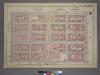
Plate 22, Part of Section 3: [Bounded by (E. 37th Street, Third Avenue, E. 32nd Street and Fifth Avenue.]
from Atlas of the city of New York, borough of Manhattan. From actual surveys and official plans / by George W. and Walter S. Bromley.
Plate 68: Map bounded by East 27th Street, Second Avenue, East 22nd Street, Fourth Avenue
from Maps of the city of New York.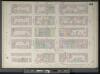
Manhattan, V. 4, Double Page Plate No. 68 [Map bounded by E. 27th St., 2nd Ave., E. 22nd St., 4th Ave.]
From Atlas 42.54. Vol. 4, 1890.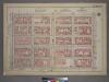
Plate 22, Part of Section 3: [Bounded by E. 37th Street, Third Avenue, E. 32nd Street and Fifth Avenue.]
from Atlas of the city of New York, borough of Manhattan. From actual surveys and official plans / by George W. and Walter S. Bromley.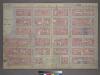
Plate 10, Part of Section 3: [Bounded by E. 26th Street, Second Avenue, E. 20th Street, Broadway, E. 23rd Street and Madison Avenue.]
from Atlas of the city of New York, borough of Manhattan. From actual surveys and official plans / by George W. and Walter S. Bromley.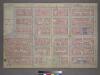
Plate 10, Part of Section 3: [Bounded by E. 26th Street, Second Avenue, E. 20th Street, Broadway, E. 23rd Street and Madison Avenue.]
from Atlas of the city of New York, borough of Manhattan. From actual surveys and official plans / by George W. and Walter S. Bromley.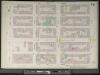
Manhattan, V. 4, Double Page Plate No. 74 [Map bounded by E. 37th St., 2nd Ave., E. 32nd St., 4th Ave.]
From Atlas 42.54. Vol. 4, 1890.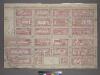
Plate 10, Part of Section 3: [Bounded by E. 26th Street, Second Avenue, E. 20th Street, Broadway, E. 23rd Street and Madison Avenue.]
from Atlas of the city of New York, borough of Manhattan. From actual surveys and official plans / by George W. and Walter S. Bromley.
[Plate 50: Bounded by E. 26th Street, Second Avenue, E. 20th Street, Broadway, and Madison Avenue.]; Atlas of the borough of Manhattan, city of New York.
from Atlas of the borough of Manhattan, city of New York. G.W. Bromley & Co.,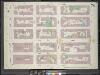
Manhattan, V. 4, Double Page Plate No. 74 [Map bounded by East 37th St., 2nd Ave., East 32nd St., Park Ave.]
From Atlas 113. Vol. 4, 1899.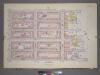
Plate 23, Part of Section 3: [Bounded by E. 37th Street, (East River Piers) First Avenue, E. 32nd Street and Third Avenue.]
from Atlas of the city of New York, borough of Manhattan. From actual surveys and official plans / by George W. and Walter S. Bromley.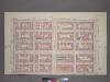
Plate 22, Part of Section 3: [Bounded by (E. 37th Street, Third Avenue, E. 32nd Street and Fifth Avenue.]
from Atlas of the city of New York, borough of Manhattan. From actual surveys and official plans / by George W. and Walter S. Bromley.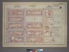
Plate 23, Part of Section 3: [Bounded by (E. 37th Street, (East River Piers) First Avenue, E. 32nd Street and Third Avenue.]
from Atlas of the city of New York, borough of Manhattan. From actual surveys and official plans / by George W. and Walter S. Bromley.
[Plate 82: Map bounded by East 37th Street, Second Avenue, East 32nd Street, Fourth Avenue.]
from Maps of the city of New York / surveyed under directions of insurance companies of said city.
![Manhattan, V. 4, Double Page Plate No. 71 [Map bounded by E. 32nd St., 2nd Ave., E. 27th St., 4th Ave.]](https://images-2.georeferencer.com/images/iiif/146665568610/full/,300/0/native.jpg)

