Maps of Bergen County

Manhattan, V. 12, Plate No. 6 [Map bounded by W. 181st St., Amsterdam Ave., W. 175th St., 11th Ave.]
From Atlas 128. Vol. 12, 1900.
Manhattan, V. 12, Plate No. 10 [Map bounded by St. Nicholas Ave., W. 179th St., Amsterdam Ave.,, W. 176th St.]
From Atlas 129. Vol. 12, 1913.
Manhattan, V. 12, Plate No. 19 [Map bounded by St. Nicholas Ave., W. 182nd St., Amsterdam Ave., W. 179th St.]
From Atlas 129. Vol. 12, 1913.
Manhattan, V. 12, Plate No. 8 [Map bounded by St. Nicholas Ave., W. 176th St., Amsterdam Ave., W. 173rd St.]
From Atlas 129. Vol. 12, 1913.
Manhattan, V. 12, Plate No. 18 [Map bounded by W. 183rd St., St. Nicholas Ave., W. 179th St., Broadway]
From Atlas 129. Vol. 12, 1913.
Manhattan, V. 12, Plate No. 9 [Map bounded by Fort Washington Ave., W. 179th St., St. Nicholas Ave., W. 176th St.]
From Atlas 129. Vol. 12, 1913.
Plate 171: Bounded by W. 178th Street, Amsterdam Avenue (Highbridge Park, Speedway), W. 173rd Street and Broadway.
from Atlas of the borough of Manhattan, city of New York.
Part of Section 8: Plate 173
from Atlas of the borough of Manhattan, city of New York.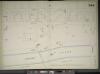
Manhattan, V. 11 1/2, Double Page Plate No. 244 [Map bounded by Audubon Ave., W. 181st St., Harlem River, W. 170th St.]
From Atlas 42.61. Vol. 11-11 1/2, 1893.
Manhattan, V. 12, Plate No. 12 [Map bounded by Harlem River, Amsterdam Ave.]
From Atlas 128. Vol. 12, 1900.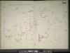
Manhattan, V. 11 1/2, Double Page Plate No. 245 [Map bounded by Fort Washington Ave., W. 181st St., Audubon Ave., W. 170th St.]
From Atlas 42.61. Vol. 11-11 1/2, 1893.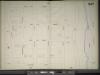
Manhattan, V. 11 1/2, Double Page Plate No. 247 [Map bounded by W. 187th St., Harlem River, Reynolds Place., Broadway]
From Atlas 42.61. Vol. 11-11 1/2, 1893.
Manhattan, V. 12, Plate No. 5 [Map bounded by W. 181st St., W. 175th St., Fort Washington Ave.]
From Atlas 128. Vol. 12, 1900.
Manhattan, V. 12, Plate No. 7 [Map bounded by Broadway, W. 185th St., Amsterdam Ave., W. 181st St.]
From Atlas 128. Vol. 12, 1900.
Manhattan, V. 12, Plate No. 4 [Map bounded by W. 175th St., Amsterdam Ave., W. 170th St., 11th Ave.]
From Atlas 128. Vol. 12, 1900.
Manhattan, V. 12, Plate No. 6 [Map bounded by Fort Washington Ave., W. 176th St., St. Nicholas Ave., W. 173rd St.]
From Atlas 129. Vol. 12, 1913.
Manhattan, V. 12, Plate No. 20 [Map bounded by St. Nicholas Ave., W. 185th St., Laurel Hill Terrace, W. 182nd St.]
From Atlas 129. Vol. 12, 1913.
Manhattan, V. 12, Plate No. 7 [Map bounded by St. Nicholas Ave., W. 173rd St., Amsterdam Ave., W. 170th St.]
From Atlas 129. Vol. 12, 1913.
Manhattan, V. 12, Plate No. 3 [Map bounded by W. 175th St., 11th Ave., W. 170th St., Fort Washington Ave.]
From Atlas 128. Vol. 12, 1900.
Manhattan, V. 12, Plate No. 14 [Map bounded by Northern Ave., W. 181st St., Broadway, W. 179th St.]
From Atlas 129. Vol. 12, 1913.
Part of Section 8 : New York City.
from Atlas of the city of New York, borough of Manhattan. From actual surveys and official plans / by George W. and Walter S. Bromley.
Page 24: [Bounded by 199th Street, Harlem River, 177th Street and Hudson River.]
from Sackersdorf Farm Set.
Fort Washington section.
From Manhattan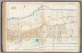
Pl. 44: ward 12.
1 : 3600 Bromley, George Washington; Bromley, Walter Scott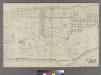
[Plate 31: Bounded by Harlem River, W. 166th Street, Hudson River...]
from Atlas of the city of New York : embracing all territory within its corporate limits from official records, private plans & actual surveys / by and under the supervision of E. Robinson & R.H. Pidgeon, civil engineers.
Page 23: [Bounded by W. 177th Street, Harlem River, w. 157th Street and Hudson River.]
from Maps of farms commonly called the Blue book, 1815 : drawn from the original on file in the street commissioner's office in the City of New York, together with lines of streets and avenues / laid out by John Randel, jr., 1819-20.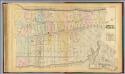
32. Ward 12.
1 : 3600 G.W. Bromley & Co.; Geo. W. Bromley & E. Robinson
Fort Washington section.
From Manhattan
[Plate 47: Bounded by Harlem River, W. 182nd Street, W. 183rd Street, and Hudson River.]
from Atlas of the city of New York, borough of Manhattan. From actual surveys and official plans / by George W. and Walter S. Bromley.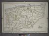
![Manhattan, V. 12, Plate No. 6 [Map bounded by W. 181st St., Amsterdam Ave., W. 175th St., 11th Ave.]](https://images-2.georeferencer.com/images/iiif/818759776184/full/,300/0/native.jpg)

