Maps of Bergen County

Manhattan, V. 12, Plate No. 2 [Map bounded by Hudson River, W. 181st St., Fort Washington Ave.]
From Atlas 128. Vol. 12, 1900.
Manhattan, V. 11 1/2, Double Page Plate No. 246 [Map bounded by Hudson River, W. 181st St., Fort Washington Ave.]
From Atlas 42.61. Vol. 11-11 1/2, 1893.
Part of Section 8: Plate 170
from Atlas of the borough of Manhattan, city of New York.
Plate 172: Bounded by W. 181st Street, Bennet Avenue, W. 184th Street, Broadway, W. 178th Street and (Fort Washington Park, Hudson River) Riverside Drive.
from Atlas of the borough of Manhattan, city of New York.
Manhattan, V. 12, Plate No. 1 [Map bounded by Hudson River, Fort Washington Ave., W. 170th St.]
From Atlas 128. Vol. 12, 1900.
Manhattan, V. 12, Plate No. 12 [Map bounded by Hudson River, Riverside Drive]
From Atlas 129. Vol. 12, 1913.
Manhattan, V. 12, Plate No. 2 [Map bounded by Hudson River, Haven Ave.]
From Atlas 129. Vol. 12, 1913.
Manhattan, V. 12, Plate No. 4 [Map bounded by W. 179th St., Fort Washington Ave., W. 175th St., Haven Ave.]
From Atlas 129. Vol. 12, 1913.
Manhattan, V. 12, Plate No. 11 [Map bounded by Hudson River, Riverside Drive]
From Atlas 129. Vol. 12, 1913.
Manhattan, V. 12, Plate No. 13 [Map bounded by W. 181st St., Northern Ave., W. 177th St., Riverside Drive]
From Atlas 129. Vol. 12, 1913.
Manhattan, V. 12, Plate No. 14 [Map bounded by Northern Ave., W. 181st St., Broadway, W. 179th St.]
From Atlas 129. Vol. 12, 1913.
Manhattan, V. 12, Plate No. 15 [Map bounded by Hudson River, Northern Ave., W. 181st St.]
From Atlas 129. Vol. 12, 1913.
Manhattan, V. 12, Plate No. 16 [Map bounded by Northern Ave., Fort Washington Ave., W. 181st St.]
From Atlas 129. Vol. 12, 1913.
Manhattan, V. 12, Plate No. 9 [Map bounded by Fort Washington Ave., W. 179th St., St. Nicholas Ave., W. 176th St.]
From Atlas 129. Vol. 12, 1913.
Part of Section 8 : New York City.
from Atlas of the city of New York, borough of Manhattan. From actual surveys and official plans / by George W. and Walter S. Bromley.
Manhattan, V. 12, Plate No. 9 [Map bounded by Hudson River, Broadway, W. 181st St.]
From Atlas 128. Vol. 12, 1900.
Manhattan, V. 11 1/2, Double Page Plate No. 245 [Map bounded by Fort Washington Ave., W. 181st St., Audubon Ave., W. 170th St.]
From Atlas 42.61. Vol. 11-11 1/2, 1893.
Manhattan, V. 12, Plate No. 5 [Map bounded by W. 181st St., W. 175th St., Fort Washington Ave.]
From Atlas 128. Vol. 12, 1900.
Manhattan, V. 11 1/2, Double Page Plate No. 248 [Map bounded by Hudson River, Broadway, (Un-Named) Road]
From Atlas 42.61. Vol. 11-11 1/2, 1893.
[Plate 168: Bounded by W. 173rd Street, St.Nicholas Avenue, W. 168th Street, ...(Harlem River, Fort Washington Park) Riverside Drive.]
from Atlas of the borough of Manhattan, city of New York.
Part of Section 8: Plate 174
from Atlas of the borough of Manhattan, city of New York.
Manhattan, V. 12, Plate No. 3 [Map bounded by W. 175th St., Fort Washington Ave., W. 170th St., Haven Ave.]
From Atlas 129. Vol. 12, 1913.
Manhattan, V. 12, Plate No. 6 [Map bounded by Fort Washington Ave., W. 176th St., St. Nicholas Ave., W. 173rd St.]
From Atlas 129. Vol. 12, 1913.
Manhattan, V. 12, Plate No. 17 [Map bounded by W. 186th St., Broadway, W. 181st St., Fort Washington Ave.]
From Atlas 129. Vol. 12, 1913.
Manhattan, V. 12, Plate No. 3 [Map bounded by W. 175th St., 11th Ave., W. 170th St., Fort Washington Ave.]
From Atlas 128. Vol. 12, 1900.
Fort Washington section.
From Manhattan
Pl. 44: ward 12.
1 : 3600 Bromley, George Washington; Bromley, Walter Scott
[Plate 31: Bounded by Harlem River, W. 166th Street, Hudson River...]
from Atlas of the city of New York : embracing all territory within its corporate limits from official records, private plans & actual surveys / by and under the supervision of E. Robinson & R.H. Pidgeon, civil engineers.
Part of Section 8: New York City.
from Atlas of the city of New York, Manhattan Island. From actual surveys and official plans / by George W. and Walter S. Bromley.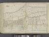
![Manhattan, V. 12, Plate No. 2 [Map bounded by Hudson River, W. 181st St., Fort Washington Ave.]](https://images-2.georeferencer.com/images/iiif/052773605076/full/,300/0/native.jpg)

