Maps of Bergen County
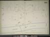
Manhattan, V. 11 1/2, Double Page Plate No. 244 [Map bounded by Audubon Ave., W. 181st St., Harlem River, W. 170th St.]
From Atlas 42.61. Vol. 11-11 1/2, 1893.
Manhattan, V. 12, Plate No. 12 [Map bounded by Harlem River, Amsterdam Ave.]
From Atlas 128. Vol. 12, 1900.
Plate 171: Bounded by W. 178th Street, Amsterdam Avenue (Highbridge Park, Speedway), W. 173rd Street and Broadway.
from Atlas of the borough of Manhattan, city of New York.
Manhattan, V. 12, Plate No. 6 [Map bounded by W. 181st St., Amsterdam Ave., W. 175th St., 11th Ave.]
From Atlas 128. Vol. 12, 1900.
Part of Section 8: Plate 173
from Atlas of the borough of Manhattan, city of New York.
Manhattan, V. 12, Plate No. 4 [Map bounded by W. 175th St., Amsterdam Ave., W. 170th St., 11th Ave.]
From Atlas 128. Vol. 12, 1900.
Manhattan, V. 12, Plate No. 10 [Map bounded by St. Nicholas Ave., W. 179th St., Amsterdam Ave.,, W. 176th St.]
From Atlas 129. Vol. 12, 1913.
Manhattan, V. 12, Plate No. 8 [Map bounded by St. Nicholas Ave., W. 176th St., Amsterdam Ave., W. 173rd St.]
From Atlas 129. Vol. 12, 1913.
Manhattan, V. 12, Plate No. 7 [Map bounded by St. Nicholas Ave., W. 173rd St., Amsterdam Ave., W. 170th St.]
From Atlas 129. Vol. 12, 1913.
Manhattan, V. 12, Plate No. 19 [Map bounded by St. Nicholas Ave., W. 182nd St., Amsterdam Ave., W. 179th St.]
From Atlas 129. Vol. 12, 1913.
Manhattan, V. 12, Plate No. 9 [Map bounded by Fort Washington Ave., W. 179th St., St. Nicholas Ave., W. 176th St.]
From Atlas 129. Vol. 12, 1913.
Manhattan, V. 12, Plate No. 6 [Map bounded by Fort Washington Ave., W. 176th St., St. Nicholas Ave., W. 173rd St.]
From Atlas 129. Vol. 12, 1913.
Part of Section 8 : New York City.
from Atlas of the city of New York, borough of Manhattan. From actual surveys and official plans / by George W. and Walter S. Bromley.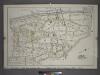
Plate 10: Part of Section 9, Borough of the Bronx. [Bounded by Sedgwick Avenue, Washington Bridge, Boscobel Avenue, Cromwell Avenue, E. 165th Street, Jerome Avenue and E. 165th Street.]
from Atlas and owners names, borough of the Bronx, sections 9 & 10 : from actual surveys and official plans / by George W. and Walter S. Bromley.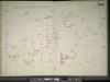
Manhattan, V. 11 1/2, Double Page Plate No. 245 [Map bounded by Fort Washington Ave., W. 181st St., Audubon Ave., W. 170th St.]
From Atlas 42.61. Vol. 11-11 1/2, 1893.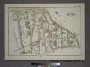
Plate 17, Part of Section 9, Borough of the Bronx. [Bounded by Washington Bridge, Boscobel Avenue, W. 169th Street and Harlem River.]
from Atlas of borough of the Bronx, Sections 9 10 11 12 & 13 : from actual surveys and official plans / G.W. Bromley and Co.
Plate 169: Bounded by W. 173rd Street, Amsterdam Avenue, Edgecombe Avenue (High Bridge Park, Speedway, Harlem River), W. 167th Street, and Broadway.
from Atlas of the borough of Manhattan, city of New York.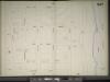
Manhattan, V. 11 1/2, Double Page Plate No. 247 [Map bounded by W. 187th St., Harlem River, Reynolds Place., Broadway]
From Atlas 42.61. Vol. 11-11 1/2, 1893.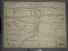
Double Page Plate No. 1, Part of Ward 24, Section 9. [Bounded by Harlem River, Old Croton Aqueduct, Nelson Avenue, E. 170th St., and High Bridge.]
from Atlas of the borough of the Bronx, city of New York : based upon official plans and maps on file in the various city offices; supplemented by careful field measurements and personal observations, by and under the supervision of Hugo Ullitz.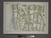
Plate 16, Part of Section 9, Borough of the Bronx. [Bounded by Depot Place, Sedgwick Avenue, Boscobel Avenue, Jerome Avenue, W. 166th Street and Harlem River.]
from Atlas of borough of the Bronx, Sections 9 10 11 12 & 13 : from actual surveys and official plans / G.W. Bromley and Co.
Manhattan, V. 12, Plate No. 5 [Map bounded by W. 181st St., W. 175th St., Fort Washington Ave.]
From Atlas 128. Vol. 12, 1900.
Manhattan, V. 12, Plate No. 7 [Map bounded by Broadway, W. 185th St., Amsterdam Ave., W. 181st St.]
From Atlas 128. Vol. 12, 1900.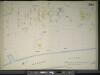
Manhattan, V. 11, Double Page Plate No. 263 [Map bounded by Amsterdam Ave., Harlem River, W. 162nd St.]
From Atlas 42.61. Vol. 11-11 1/2, 1893.
Manhattan, V. 12, Plate No. 18 [Map bounded by W. 183rd St., St. Nicholas Ave., W. 179th St., Broadway]
From Atlas 129. Vol. 12, 1913.
Manhattan, V. 12, Plate No. 3 [Map bounded by W. 175th St., 11th Ave., W. 170th St., Fort Washington Ave.]
From Atlas 128. Vol. 12, 1900.
Manhattan, V. 12, Plate No. 20 [Map bounded by St. Nicholas Ave., W. 185th St., Laurel Hill Terrace, W. 182nd St.]
From Atlas 129. Vol. 12, 1913.
Manhattan, V. 12, Plate No. 5 [Map bounded by Fort Washington Ave., W. 173rd St., St. Nicholas Ave., W. 170th St.]
From Atlas 129. Vol. 12, 1913.
Fort Washington section.
From Manhattan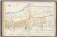
Pl. 44: ward 12.
1 : 3600 Bromley, George Washington; Bromley, Walter Scott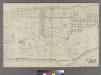
![Manhattan, V. 11 1/2, Double Page Plate No. 244 [Map bounded by Audubon Ave., W. 181st St., Harlem River, W. 170th St.]](https://images-2.georeferencer.com/images/iiif/105835835090/full/,300/0/native.jpg)

