Maps of Weehawken

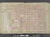
Key
From Atlas 42.55. Vol. 5, 1890.
Map of the city of New-York extending northward to Fiftieth St. / surveyed and drawn by John F. Harrison, C.E.
from Manhattan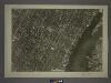
8D - N.Y. City (Aerial Set).
from Sectional aerial maps of the City of New York / [photographed and assembled under the direction of the chief engineer, July 1st, 1924].
Map showing the high and low water mark and the original city grants of lands under water made to various parties from 1686 to 1873, extending from Battery to Fifty-first Street, Hudson and East Rivers, New York City, also the several pier and bulkhead l
from Whole
Sheet 9: [Bounded by Twelfth Avenue, W. Fortieth Street, Sixth Avenue and W. Twentieth Street.]
from Plan of New York City, from the Battery to Spuyten Duyvil Creek. Showing every lot and building thereon; old farm lines, strreet numbers at the corners of blocks, railroads, steamboat landings, bulkhead and pier lines, etc. Based on the surveys made by Messrs. Randall & Blackwell, and on the special survey by J. F. Harrison.
Sheet 11: [Bounded by Fifty Ninth Street, Seventh Avenue, W. Fortieth Street and Thirteenth Avenue.]
from Plan of New York City, from the Battery to Spuyten Duyvil Creek. Showing every lot and building thereon; old farm lines, strreet numbers at the corners of blocks, railroads, steamboat landings, bulkhead and pier lines, etc. Based on the surveys made by Messrs. Randall & Blackwell, and on the special survey by J. F. Harrison.
Sackersdorff Farm Set.
from Maps of farms commonly called the Blue book, 1815 : drawn from the original on file in the street commissioner's office in the City of New York, together with lines of streets and avenues / laid out by John Randel, jr., 1819-20.
Page 8: [Bounded by W. 57th Street, Eighth Avenue (Fashion Center), W. 37th Street and Hudson River.]
from Sackersdorf Farm Set.
Sackersdorff Farm Set.
from Sackersdorf Farm Set.
The city of New York / Will L. Taylor, chief draughtsman.
from Whole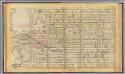
14. Ward 20.
1 : 2400 G.W. Bromley & Co.; Geo. W. Bromley & E. Robinson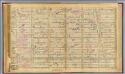
15. Wards 20, 22.
1 : 2400 G.W. Bromley & Co.; Geo. W. Bromley & E. Robinson
[Plate 22: Bounded by Sixth Avenue, Central Park South, Fifth Avenue, E. 64th Street, Lexington Avenue, and E. 47th Street.]
from Atlas of the city of New York, borough of Manhattan. From actual surveys and official plans / by George W. and Walter S. Bromley.
Map of the city of New-York extending northward to Fiftieth St. / surveyed and drawn by John F. Harrison, C.E.
from Manhattan
Key
From Atlas 42.53. Vol. 3, 1895.
Sheet 10: [Bounded by E. Fortieth Street, First Avenue, E. Twentieth Street and Sixth Avenue.]
from Plan of New York City, from the Battery to Spuyten Duyvil Creek. Showing every lot and building thereon; old farm lines, strreet numbers at the corners of blocks, railroads, steamboat landings, bulkhead and pier lines, etc. Based on the surveys made by Messrs. Randall & Blackwell, and on the special survey by J. F. Harrison.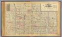
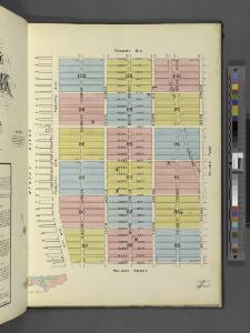
16. Ward 22.
1 : 2400 G.W. Bromley & Co.; Geo. W. Bromley & E. Robinson
Pl. 23: ward 22.
1 : 1800 Bromley, George Washington; Bromley, Walter Scott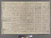
[Plate 14: Bounded by W. 40th Street, Sixth Avenue, W. 27th Street and Twelfth Avenue.]
from Atlas of the city of New York : embracing all territory within its corporate limits from official records, private plans & actual surveys / by and under the supervision of E. Robinson & R.H. Pidgeon, civil engineers.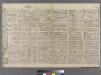
Plate 15: Bounded by W. 52nd Street, Sixth Avenue, W. 40th Street, and (Hudson River) Twelfth Avenue.
from Atlas of the city of New York : embracing all territory within its corporate limits from official records, private plans & actual surveys / by and under the supervision of E. Robinson & R.H. Pidgeon, civil engineers.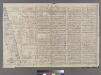
Part of Wards 16 &20, New York City.
from Atlas of the city of New York : embracing all territory within its corporate limits from official records, private plans & actual surveys / by and under the supervision of E. Robinson & R.H. Pidgeon, civil engineers.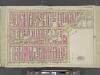
Manhattan, Double Page Plate No. 23 [Map bounded by 9th Ave., W. 59th St., 6th Ave., W. 47th St.]
From Atlas of the city of New York, Manhattan Island. From actual surveys and official plans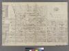
Part of Ward 22, New York City.
from Atlas of the city of New York : embracing all territory within its corporate limits from official records, private plans & actual surveys / by and under the supervision of E. Robinson & R.H. Pidgeon, civil engineers.
Manhattan, Double Page Plate No. 19 [Map bounded by W. 47th St., 8th Ave., W. 36th St., Hudson River]
From Atlas of the city of New York, Manhattan Island. From actual surveys and official plans
Plate 13: Bounded by W. 25th Street, Seventh Avenue, W. 14th Street, [Hudson River, Pierhead Line, Piers 57-62], and Thirteenth Avenue.]
from Atlas of the city of New York, borough of Manhattan. From actual surveys and official plans / by George W. and Walter S. Bromley.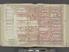
Manhattan, Double Page Plate No. 18 [Map bounded by W. 36th St., 8th Ave., W. 25th St., Hudson River]
From Atlas of the city of New York, Manhattan Island. From actual surveys and official plans
Manhattan, Double Page Plate No. 17 [Map bounded by E. 36th St., Lexington Ave., W. 25th St., 8th Ave.]
From Atlas of the city of New York, Manhattan Island. From actual surveys and official plans
Manhattan, Double Page Plate No. 20 [Map bounded by W. 47th St., Lexington Ave., W. 36th St., 8th Ave.]
From Atlas of the city of New York, Manhattan Island. From actual surveys and official plans
[Plate 23: Bounded by Ninth Avenue, Columbus Avenue, W. 64th Street, Central Park West, Columbus Circle, Central Park South, Sixth Avenue, and W. 47th Street.]
from Atlas of the city of New York, borough of Manhattan. From actual surveys and official plans / by George W. and Walter S. Bromley.