Maps of Hudson County
Manhattan, V. 3, Double Page Plate No. 65 [Map bounded by W. 22nd St., 6th Ave., W. 17th St., 8th Ave.]
From Atlas 42.53. Vol. 3, 1895.
[Plate 72: Map bounded by West 22nd Street, Sixth Avenue, West 18th Street, Eighth Avenue.]
from Maps of the city of New York / surveyed under directions of insurance companies of said city.
Plate 64: Map bounded by West 22nd Street, Sixth Avenue, West 17th Street, Eight Avenue
from Maps of the city of New York.
Page 2: [Bounded by Abingdon Road, Loves Lane, Sixth Avenue, W. Eleventh Street, Seventh Avenue, W. Fourteenth Street and Fitz Roy Road.]
from Maps of farms commonly called the Blue book, 1815 : drawn from the original on file in the street commissioner's office in the City of New York, together with lines of streets and avenues / laid out by John Randel, jr., 1819-20.
Plate 5, Part of Section 3: [Bounded by W. 20th Street, Seventh Avenue, W. 14th Street and Ninth Avenue.]
from Atlas of the city of New York, borough of Manhattan. From actual surveys and official plans / by George W. and Walter S. Bromley.
Plate 5, Part of Section 3: [Bounded by W. 20th Street, Seventh Avenue, W. 14th Street and Ninth Avenue.]
from Atlas of the city of New York, borough of Manhattan. From actual surveys and official plans / by George W. and Walter S. Bromley.
Part of Section : Plate 42.
from Atlas of the borough of Manhattan, city of New York.
Part of Section 3 : Plate 48.
from Atlas of the borough of Manhattan, city of New York.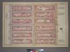
Plate 8, Part of Section 3: [Bounded by W. 26th Street, Seventh Avenue, W. 20th Street and (Chelsea Square) Ninth Avenue.]
from Atlas of the city of New York, borough of Manhattan. From actual surveys and official plans / by George W. and Walter S. Bromley.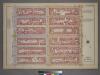
Plate 8, Part of Section 3: [Bounded by W. 26th Street, Seventh Avenue, W. 20th Street and Ninth Avenue.]
from Atlas of the city of New York, borough of Manhattan. From actual surveys and official plans / by George W. and Walter S. Bromley.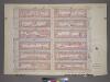
Plate 8, Part of Section 3: [Bounded by W. 26th Street, Seventh Avenue, W. 20th Street and Ninth Avenue.]
from Atlas of the city of New York, borough of Manhattan. From actual surveys and official plans / by George W. and Walter S. Bromley.
Plate 43: Bounded by W. 20th Street, Broadway, [Washington Square], E. 14th Street, W. 14th Street, and Seventh Avenue.
from Atlas of the borough of Manhattan, city of New York.
[Plate 49: Bounded by W. 26th Street, Broadway (Madison Square), W. 20th Street, and Seventh Avenue.]
from Atlas of the borough of Manhattan, city of New York.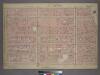
Plate 4, Part of Section 3: [Bounded by W. 20th Street, W. 20th Street, Broadway, Union Square, E. 14th Street, W. 14th Street and Seventh Avenue.]
from Atlas of the city of New York, borough of Manhattan. From actual surveys and official plans / by George W. and Walter S. Bromley.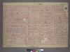
Plate 4, Part of Section 3: [Bounded by W. 20th Street, E. 20th Street, Broadway, Union Square, E. 14th Street, W. 14th Street and Seventh Avenue.]
from Atlas of the city of New York, borough of Manhattan. From actual surveys and official plans / by George W. and Walter S. Bromley.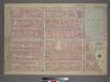
Plate 9, Part of Section 3: [Bounded by W. 26th Street, E. 26th Street, Madison Avenue, W. 23rd Street, Broadway, E. 20th Street, W. 20th Street and Seventh Avenue.]
from Atlas of the city of New York, borough of Manhattan. From actual surveys and official plans / by George W. and Walter S. Bromley.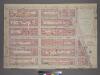
Plate 9, Part of Section 3: [Bounded by W. 26th Street, E. 26th Street, Madison Avenue, W. 23rd Street, Broadway, E. 20th Street, W. 20th Street and Seventh Avenue.]
from Atlas of the city of New York, borough of Manhattan. From actual surveys and official plans / by George W. and Walter S. Bromley.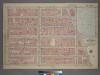
Plate 9, Part of Section 3: [Bounded by W. 26th Street, Fifth Avenue, Broadway, E. 20th Street, W. 20th Street and Seventh Avenue.]
from Atlas of the city of New York, borough of Manhattan. From actual surveys and official plans / by George W. and Walter S. Bromley.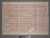
Plate 4, Part of Section 3: [Bounded by W. 20th Street, E. 20th Street, Second Avenue, Broadway, E. 14th Street, W. 14th Street and Seventh Avenue.]
from Atlas of the city of New York, borough of Manhattan. From actual surveys and official plans / by George W. and Walter S. Bromley.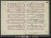
Manhattan, V. 5, Double Page Plate No. 85 [Map bounded by W. 27th St., 6th Ave., W. 22nd St., 8th Ave.]
From Atlas 42.55. Vol. 5, 1890.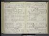
[Plate 70: Map bounded by West 17th Street, Sixth Avenue, West 13th Street, Greenwich Avenue, Eighth Avenue.]
from Maps of the city of New York / surveyed under directions of insurance companies of said city.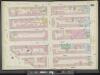
Manhattan, V. 3, Double Page Plate No. 62 [Map bounded by W. 17th St., 6th Ave., W. 12th St., Greenwich Ave., 8th Ave.]
From Atlas 42.53. Vol. 3, 1895.
Plate 62: Map bounded by West 17th Street, Sixth Avenue, 12th Street, Greenwich Avenue, Eighth Avenue
from Maps of the city of New York.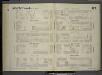
[Plate 87: Map bounded by West 27th Street, Sixth Avenue, West 22nd Street, Eighth Avenue.]
from Maps of the city of New York / surveyed under directions of insurance companies of said city.
Plate 85: Map bounded by West 27th Street, Sixth Avenue, West 22nd Street, Eighth Avenue
from Maps of the city of New York.
Plate 48: Map bounded by West 22nd Street, East 22nd Street, Fourth Avenue, Union Square North, Broadway, East 18th Street, West 18th Street, Sixth Avenue
from Maps of the city of New York.
Manhattan, V. 3, Double Page Plate No. 66 [Map bounded by W. 22nd St., 8th Ave., W. 17th St., 10th Ave.]
From Atlas 42.53. Vol. 3, 1895.
Manhattan, V. 2, Plate No. 41 [Map bounded by 6th Ave., W. 20th St., 5th Ave., W. 17th St.]
From Atlas 110. Vol. 2, 1903.
Manhattan, V. 2, Plate No. 42 [Map bounded by 6th Ave., W. 22nd St., 5th Ave., W. 20th St.]
From Atlas 110. Vol. 2, 1903.
![Manhattan, V. 3, Double Page Plate No. 65 [Map bounded by W. 22nd St., 6th Ave., W. 17th St., 8th Ave.]](https://images-2.georeferencer.com/images/iiif/290203598063/full/,300/0/native.jpg)

