Maps of Hudson County

Manhattan, V. 3, Plate No. 57 [Map bounded by University Pl., E. 12th St., 4th Ave., E. 9th St.]
From Atlas 42.53. Vol. 3, 1895.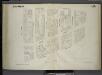
[Plate 65: Map bounded by University Place, East 14th Street, Fourth Avenue, East 9th Street.]
from Maps of the city of New York / surveyed under directions of insurance companies of said city.
Plate 57: Map bounded by 14th Street, Fourth Avenue, 9th Street, University Place
from Maps of the city of New York.
Manhattan, V. 2, Plate No. 25 [Map bounded by E. 14th St., 3rd Ave., E. 10th St., 4th Ave.]
From Atlas 110. Vol. 2, 1903.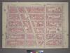
Plate 30, Part of Section 2: [Bounded by E. 14th Street, Second Avenue, E. 8th Street and University Place.]
from Atlas of the city of New York, borough of Manhattan. From actual surveys and official plans / by George W. and Walter S. Bromley.
[Plate 30: Bounded by E. 14th Street, Second Avenue, E. 8th Street, and University Place.]
from Atlas of the borough of Manhattan, city of New York.
[Plate 31: Bounded by W. 8th Street, E. 8th Street, Broadway, W. 3rd Street, Macdougal, Washington Square, and West Street.]
from Atlas of the borough of Manhattan, city of New York.
[Plate 61: Map bounded by East 9th Street, Fourth Avenue, Bowery, East 4th Street, University Place.]
from Maps of the city of New York / surveyed under directions of insurance companies of said city.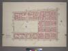
Plate 31, Part of Section 2: [Bounded by W. 8th Street, Broadway, W. 3rd Street, McDougal Washington Square and West Street.]
from Atlas of the city of New York, borough of Manhattan. From actual surveys and official plans / by George W. and Walter S. Bromley.
Plate 53: Map bounded by 9th Street, Fourth Avenue, 4th Street, University Place
from Maps of the city of New York.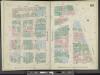
Manhattan, V. 3, Double Page Plate No. 53 [Map bounded by E. 9th St., 4th Ave., E. 4th St., Wooster St., University Pl.]
From Atlas 42.53. Vol. 3, 1895.
Plate 41: Map bounded by East 12th Street, Second Avenue, 5th Street, Fourth Avenue
from Maps of the city of New York.
Manhattan, V. 3, Plate No. 23 [Map bounded by E. 9th St., Broadway, W. 4th St., Washington Sq.]
From Atlas 112. Vol. 3, 1904.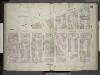
[Plate 41: Map bounded by Fourth Avenue, East 12th Street, Second Avenue, Fifth Street; Including Bowery, Third Avenue, Sixth Street, Seventh Street, Eighth Street (St.Mark's Place), Astor Place, Stuyvesant Street, East Ninth Street, East 10t
from Insurance maps of the city of New York.
Manhattan, V. 3, Plate No. 24 [Map bounded by E. 9th St., 4th Ave., E. 4th Ave., Broadway]
From Atlas 112. Vol. 3, 1904.
Manhattan, V. 2, Plate No. 17 [Map bounded by E. 10th St., 3rd Ave., 4th Ave.]
From Atlas 110. Vol. 2, 1903.
Plate 49: Map bounded by East 12th Street, Second Avenue, Fifth Street, Bowery, Fourth Avenue.
from Maps of the city of New York / surveyed under directions of insurance companies of said city.
Manhattan, V. 3, Plate No. 57 [Map bounded by University Pl., E. 14th St., 4th Ave., E. 12th St.]
From Atlas 42.53. Vol. 3, 1895.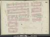
Manhattan, Double Page Plate No. 54 [Map bounded by E. 10th St., Wooster St., University Pl., W. 4th St., 6th Ave., W. 10th St.]
From Atlas 42.53. Vol. 3, 1895.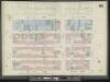
Manhattan, V. 3, Double Page Plate No. 58 [Map bounded by E. 14th St., University Pl., E. 10th St., W. 10th St., 6th Ave., W. 14th St.]
From Atlas 42.53. Vol. 3, 1895.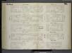
[Plate 66: Map bounded by West 14th Street, East 14th Street, University Place, East 9th Street, West 9th Street, Sixth Avenue.]
from Maps of the city of New York / surveyed under directions of insurance companies of said city.
Plate 58: Map bounded by 14th Street, University Place, 9th Street, Sixth Avenue
from Maps of the city of New York.
Plate 54: Map bounded by 9th Street, University Place, 4th Street, Sixth Avenue
from Maps of the city of New York.
Plate 52: Map bounded by East 17th Street, Second Avenue, East 12th Street, Bowery, Fourth Avenue.
from Maps of the city of New York / surveyed under directions of insurance companies of said city.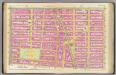
Pl. 11: wards 15, 17.
1 : 1800 Bromley, George Washington; Bromley, Walter Scott
Part of Section 2 : New York City.
from Atlas of the city of New York, Manhattan Island. From actual surveys and official plans / by George W. and Walter S. Bromley.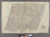
Part of Wards 9 & 15, New York City.
from Atlas of the city of New York : embracing all territory within its corporate limits from official records, private plans & actual surveys / by and under the supervision of E. Robinson & R.H. Pidgeon, civil engineers.
Part of Section 2 : New York City.
from Atlas of the city of New York, borough of Manhattan. From actual surveys and official plans / by George W. and Walter S. Bromley.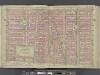
Manhattan, Double Page Plate No. 11 [Map bounded by E. 14th St., 1st Ave., W. 3rd St., 6th Ave.]
From Atlas of the city of New York, Manhattan Island. From actual surveys and official plans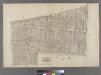
![Manhattan, V. 3, Plate No. 57 [Map bounded by University Pl., E. 12th St., 4th Ave., E. 9th St.]](https://images-2.georeferencer.com/images/iiif/316734713070/full/,300/0/native.jpg)

