Maps of Hudson County
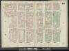
Manhattan, V. 3, Double Page Plate No. 50 [Map bounded by W. 4th St., Greene St., W. Houston St., Hancock St., Minetta St., 6th Ave.]
From Atlas 42.53. Vol. 3, 1895.
Plate 50: Map bounded by 4th Street, Green Street, Houston Street, Hancock Street, Bleeker Street, Carmine Street, Sixth Avenue
from Maps of the city of New York.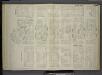
[Plate 58: Map bounded by West 4th Street, East 4th Street, Green Street, Houston Street, Hancock Street, Bleecker Street, Carmine Street, Sixth Avenue.]
from Maps of the city of New York / surveyed under directions of insurance companies of said city.
Manhattan, V. 1, Plate No. 22 west half [Map bounded by W. Houston St., Wooster St., Spring St., Sullivan St.]
From Atlas 107. Vol. 1, 1894.
Part of Section 2 : Plate 22.
from Atlas of the borough of Manhattan, city of New York.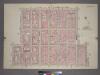
Plate 22, Part of Section 2: [Bounded by W. 3rd Street, Broadway, E. Houston Street, Prince Street, Macdougal Street, W. Houston Street and Sullivan Street.]
from Atlas of the city of New York, borough of Manhattan. From actual surveys and official plans / by George W. and Walter S. Bromley.
9. Wards 9, 15.
1 : 2400 G.W. Bromley & Co.; Geo. W. Bromley & E. Robinson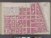
Manhattan, V. 4, Double Page Plate No. 18 [Map bounded by Waverly Place, Astor Place, Bowery, 4th Ave., E. Houston St., W. Houston St., Mac Dougal St.]
From Vol. 4
[Plate 33: Bounded by Barrow Street, Bleecker Street, Cornelia Street, Sixth Avenue, W. 3rd Street, Sullivan Street, Bedford Street, Macdougal Street, King Street, Varick Street and Second Avenue Extension.]
from Atlas of the borough of Manhattan, city of New York.
[Plate 31: Bounded by W. 8th Street, E. 8th Street, Broadway, W. 3rd Street, Macdougal, Washington Square, and West Street.]
from Atlas of the borough of Manhattan, city of New York.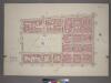
Plate 31, Part of Section 2: [Bounded by W. 8th Street, Broadway, W. 3rd Street, McDougal Washington Square and West Street.]
from Atlas of the city of New York, borough of Manhattan. From actual surveys and official plans / by George W. and Walter S. Bromley.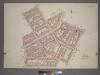
Plate 33, Part of Section 2: [Bounded by Barrow Street, Bleecker Street, W. Houston Street, Macdougal Street, King Street, Varick Street, Leroy Street and Bedford Street.]
from Atlas of the city of New York, borough of Manhattan. From actual surveys and official plans / by George W. and Walter S. Bromley.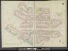
Manhattan, V. 3, Double Page Plate No. 51 [Map bounded by Commerce St., 6th Ave., Hancock St., W. Houston St., Hudson St.]
From Atlas 42.53. Vol. 3, 1895.
Plate 51: Map bounded by Bleeker Street, Cornelia Street, Sixth Avenue, Carmine Street, Bleeker Street, Hancock Street, Hammersley Street, Hudson Street, Barrow Street, Commerce Street
from Maps of the city of New York.
[Plate 62: Map bounded by West 9th Street, East 9th Street, University Place, East 4th Street, West 4th Street, Sixth Avenue.]
from Maps of the city of New York / surveyed under directions of insurance companies of said city.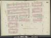
Manhattan, Double Page Plate No. 54 [Map bounded by E. 10th St., Wooster St., University Pl., W. 4th St., 6th Ave., W. 10th St.]
From Atlas 42.53. Vol. 3, 1895.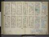
[Plate: 21 Map bounded by W.Houston Street, Crosby Street, Spring Street, Sullivan Street; Including Prince Street, Thompson Street, Laurens Street, Wooster Street, Greene Street, Mercer Street, Broadway; Map bounded by Broadway, Spring Str
from Maps of the city of New-York.
Plate 54: Map bounded by 9th Street, University Place, 4th Street, Sixth Avenue
from Maps of the city of New York.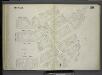
[Plate 59: Map bounded by Barrow Street, Commerce Street, Bleecker Street, Cornelia Street, Sixth Avenue, Hancock Street, Hamersly Street, Hudson Street.]
from Maps of the city of New York / surveyed under directions of insurance companies of said city.
Plate 36: Map bounded by Hamersley Street, Houston Street, Laurens Street, Spring Street, Varick Street.
from Maps of the city of New York / surveyed under directions of insurance companies of said city.
[Plate 21: Map bounded by Houston Street, Crosby Street, Broome Street, Broadway, Spring street, Sullivan Street]
from Maps of the city of New York.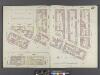
Manhattan, V. 1, Double Page Plate No. 20 [Map bounded by Varick St., Houston St., Sullivan St., Thompson St., Broomr St., Clarke St.]
From Atlas 107. Vol. 1, 1894.
Plate 32: Map bounded by Houston Street, Crosby Street, Prince Street, Marion Street, Spring Street, Laurens Street.
from Maps of the city of New York / surveyed under directions of insurance companies of said city.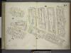
[Plate 20: Map bounded by Sullivan Street, Varick Street, West Houston Street, Spring Street, Thompson Street, Broome Street, Grand Street; Including Clarke Street, MacDougal Street, Vandam Street, Charlton Street, King Street]
from Maps of the city of New-York.
Plate 20: Map bounded by Hamersley Street, Houston Street, Sullivan Street, Spring street, Thompson Street, Grand Street, Sullivan Street, Broome Street, Clarke Street, Spring Street, Varick Street.
from Maps of the city of New York.
[Plate 57: Map bounded by East 4th Street, Bowery, Houston Street, Green Street.]
from Maps of the city of New York / surveyed under directions of insurance companies of said city.
Manhattan, V. 1, Plate No. 22 [Map bounded by W. Houston St., Broadway, Spring St., Wooster St.]
From Atlas 107. Vol. 1, 1894.
Manhattan, V. 3, Plate No. 23 [Map bounded by E. 9th St., Broadway, W. 4th St., Washington Sq.]
From Atlas 112. Vol. 3, 1904.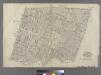
Part of Wards 9 & 15, New York City.
from Atlas of the city of New York : embracing all territory within its corporate limits from official records, private plans & actual surveys / by and under the supervision of E. Robinson & R.H. Pidgeon, civil engineers.
![Manhattan, V. 3, Double Page Plate No. 50 [Map bounded by W. 4th St., Greene St., W. Houston St., Hancock St., Minetta St., 6th Ave.]](https://images-2.georeferencer.com/images/iiif/226258913631/full/,300/0/native.jpg)

