Maps of Bronx County

Manhattan, V. 12, Plate No. 77 [Map bounded by Seaman Ave., Harlem River, Broadway, W. 219th St.]
From Atlas 129. Vol. 12, 1913.
Manhattan, V. 12, Plate No. 26 [Map bounded by Seaman Ave., Harlem River, 9th Ave., W. 216th St.]
From Atlas 128. Vol. 12, 1900.
Manhattan, V. 12, Plate No. 72 [Map bounded by Harlem River, Seaman Ave., W. 218th St.]
From Atlas 129. Vol. 12, 1913.
Manhattan, V. 12, Plate No. 76 [Map bounded by Seaman Ave., W. 219th St., Broadway]
From Atlas 129. Vol. 12, 1913.
Manhattan, V. 12, Plate No. 78 [Map bounded by Broadway, Harlem River, W. 219th St.]
From Atlas 129. Vol. 12, 1913.
Manhattan, V. 12, Plate No. 80 [Map bounded byW. 227th St., Broadway, W. 225th St., Van Corlears Place]
From Atlas 129. Vol. 12, 1913.
Plate 190: Bounded by Broadway, Columbus Avenue (Harlem River) and W. 214th Street.
from Atlas of the borough of Manhattan, city of New York.
Plate 189: Bounded by Cold Spring Road, Indian Road (Harlem River), Broadway, and W. 215th Street.
from Atlas of the borough of Manhattan, city of New York.
Part of Section 8: Plate 191
from Atlas of the borough of Manhattan, city of New York.
Manhattan, V. 12, Plate No. 29 [Map bounded by Harlem River, Spuyten Duyvil Creek]
From Atlas 128. Vol. 12, 1900.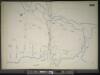
Manhattan, V. 11 1/2, Double Page Plate No. 255 [Map bounded by River St., Harlem River, W. 215th St.]
From Atlas 42.61. Vol. 11-11 1/2, 1893.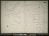
Manhattan, V. 11 1/2, Double Page Plate No. 254 [Map bounded by River St., Harlem River, Prescott Ave.]
From Atlas 42.61. Vol. 11-11 1/2, 1893.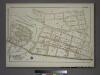
Plate 75, Part of Sections 8&13, Borough of the Bronx. [Bounded by Netherland Avenue, W. 235th Street, Spuyten Duyvil Road, W. 236th Street and Broadway.]
from Atlas of borough of the Bronx, Sections 9 10 11 12 & 13 : from actual surveys and official plans / G.W. Bromley and Co.
Part of Section 8 : New York City.
from Atlas of the city of New York, borough of Manhattan. From actual surveys and official plans / by George W. and Walter S. Bromley.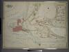
Atlas of the borough of the Bronx, city of New York : based upon official plans and maps on file in the various city offices; supplemented by careful field measurements and personal observations, by and under the supervision of Hugo Ullitz.
from Atlas of the borough of the Bronx, city of New York : based upon official plans and maps on file in the various city offices; supplemented by careful field measurements and personal observations, by and under the supervision of Hugo Ullitz.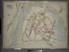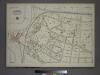
Plate 76, Part of Section 13, Borough of the Bronx. [Bounded by Spuyten Duyvil Road, W. 235th Street, Netherland Avenue, Kappock Street, W. Johnson Road and Broadway.]
from Atlas of borough of the Bronx, Sections 9 10 11 12 & 13 : from actual surveys and official plans / G.W. Bromley and Co.
Manhattan, V. 12, Plate No. 27 [Map bounded by Spuyten Duyvil Creek, Broadway, Harlem River]
From Atlas 128. Vol. 12, 1900.
Manhattan, V. 12, Plate No. 20 [Map bounded by Harlem River, Seaman Ave.]
From Atlas 128. Vol. 12, 1900.
Part of Section 8: Plate 187
from Atlas of the borough of Manhattan, city of New York.
Manhattan, V. 12, Plate No. 79 [Map bounded by W. 227th St., Jacobus Place., Harlem River, Teunissen Ave.]
From Atlas 129. Vol. 12, 1913.
Manhattan, V. 12, Plate No. 68 [Map bounded by 10th Ave., Broadway, W. 219th St., Harlem River, W. 216th St.]
From Atlas 129. Vol. 12, 1913.
Bronx, V. 13, Plate No. 4 [Map bounded by W. 227th St., Old Kingsbridge Rd., Kappock St., Arlington Ave.]
From Atlas 51.1. Vol. 13, 1914.
Manhattan, V. 12, Plate No. 75 [Map bounded by Seaman Ave., W. 217th St., Broadway, W. 214th St.]
From Atlas 129. Vol. 12, 1913.
Manhattan, V. 12, Plate No. 74 [Map bounded by Harlem River, W. 218th St., Seaman Ave., W. 213th St.]
From Atlas 129. Vol. 12, 1913.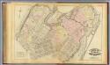
33. Ward 12.
1 : 3600 G.W. Bromley & Co.; Geo. W. Bromley & E. Robinson
Sackersdorff Farm set.
from Maps of farms commonly called the Blue book, 1815 : drawn from the original on file in the street commissioner's office in the City of New York, together with lines of streets and avenues / laid out by John Randel, jr., 1819-20.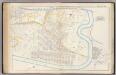
Pl. 45: ward 12.
1 : 3600 Bromley, George Washington; Bromley, Walter Scott
Sheet 20: [Bounded by 225th Street, (Spuyten Duyvel Creek Bulk Head Pier Line), 10th Avenue and 195th Street.]
from Plan of New York City, from the Battery to Spuyten Duyvil Creek. Showing every lot and building thereon; old farm lines, strreet numbers at the corners of blocks, railroads, steamboat landings, bulkhead and pier lines, etc. Based on the surveys made by Messrs. Randall & Blackwell, and on the special survey by J. F. Harrison.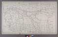
![Manhattan, V. 12, Plate No. 77 [Map bounded by Seaman Ave., Harlem River, Broadway, W. 219th St.]](https://images-2.georeferencer.com/images/iiif/149365652762/full/,300/0/native.jpg)

