Maps of Bergen County

Manhattan, V. 12, Plate No. 56 [Map bounded by Emerson Pl., Seaman Ave., Nicholas Place]
From Atlas 129. Vol. 12, 1913.
Part of Section 8: Plate 182
from Atlas of the borough of Manhattan, city of New York.
Manhattan, V. 12, Plate No. 19 [Map bounded by Harlem River, Hudson River]
From Atlas 128. Vol. 12, 1900.
Plate 186: Bounded by Bolton Road (Harlem River), Prescott Avenue and Emerson Place.
from Atlas of the borough of Manhattan, city of New York.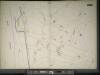
Manhattan, V. 11 1/2, Double Page Plate No. 252 [Map bounded by Bolton Rd., (Un-Named) Road, Hudson River]
From Atlas 42.61. Vol. 11-11 1/2, 1893.
Manhattan, V. 12, Plate No. 55 [Map bounded by Bolton Rd., Nicholas Place]
From Atlas 129. Vol. 12, 1913.
Manhattan, V. 12, Plate No. 40 [Map bounded by Bolton Rd., Dyckman St.]
From Atlas 129. Vol. 12, 1913.
Manhattan, V. 12, Plate No. 43 [Map bounded by Bolton Rd., Prescott Ave., Dyckman St.]
From Atlas 129. Vol. 12, 1913.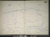
Manhattan, V. 11 1/2, Double Page Plate No. 253 [Map bounded by Hudson River, River St., Prescott Ave.]
From Atlas 42.61. Vol. 11-11 1/2, 1893.
Property identification map of Inwood Hill. [copy #1 Blue Print, 63 1/2" X 37"] [Copy # 2, Lithograph, Col., 69" X 42"]
From Manhattan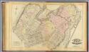
33. Ward 12.
1 : 3600 G.W. Bromley & Co.; Geo. W. Bromley & E. Robinson
[Plate 49: Bounded by Harlem River (N.Y,C. & H.R.R.R.), Channel Line (U.S. Ship Canal), Prescott Avenue, Emerson Street, Isham Street, Seaman Avenue, Emerson Street, Broadway (Kingsbridge Road), and Dyckman Street.]
from Atlas of the city of New York, borough of Manhattan. From actual surveys and official plans / by George W. and Walter S. Bromley.
Manhattan, V. 12, Plate No. 20 [Map bounded by Harlem River, Seaman Ave.]
From Atlas 128. Vol. 12, 1900.
Plate 183: Bounded by Nicholas Place, Prescott Avenue, Emerson Place, W. 207th Street, Broadway and Dyckman Street.
from Atlas of the borough of Manhattan, city of New York.
Part of Section 8: Plate 187
from Atlas of the borough of Manhattan, city of New York.
Manhattan, V. 12, Plate No. 16 [Map bounded by Hudson River, Dyckman St., Broadway]
From Atlas 128. Vol. 12, 1900.
Part of Section 8: Plate 181
from Atlas of the borough of Manhattan, city of New York.
Manhattan, V. 12, Plate No. 63 [Map bounded by Cold Spring Rd., Crosby Place]
From Atlas 129. Vol. 12, 1913.
Manhattan, V. 12, Plate No. 57 [Map bounded by W. 207th St., Broadway, Academy St., Seaman Ave.]
From Atlas 129. Vol. 12, 1913.
Manhattan, V. 12, Plate No. 42 [Map bounded by D. St., Dyckman St., Riverside Drive]
From Atlas 129. Vol. 12, 1913.
Manhattan, V. 12, Plate No. 44 [Map bounded by Prescott Ave., Academy St., Vermilyea Ave., Dyckman St.]
From Atlas 129. Vol. 12, 1913.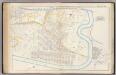
Pl. 45: ward 12.
1 : 3600 Bromley, George Washington; Bromley, Walter Scott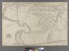
Part of Ward 12, New York City.
from Atlas of the city of New York : embracing all territory within its corporate limits from official records, private plans & actual surveys / by and under the supervision of E. Robinson & R.H. Pidgeon, civil engineers.
Plate 45: Bounded by Boulevard Lafayette (Hudson River), Harlem River ...
from Atlas of the city of New York, Manhattan Island. From actual surveys and official plans / by George W. and Walter S. Bromley.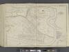
Manhattan, Double Page Plate No. 45 [Map bounded by Hudson River, Harlem River]
From Atlas of the city of New York, Manhattan Island. From actual surveys and official plans
Bronx, Topographical Map Sheet 5; [Map bounded by Morkison St., Johnson Ave., Riverdale Ave., Ackerman St., Church St., Broadway, Macomb St., Albany Road, Bailas Ave., Heath Ave., Boston Ave., Sedgwick Ave.; Including Tee-Taw Ave., Aqueduct Ave., Hamp...
From Topographical map made from surveys by the commissioners of the Department of Public Parks of the City of New York of that part of Westchester County adjacent to the City and County of New York embraced by chapter 534 of laws of 1871 as amended b...
1C - N.Y. City (Aerial Set).
from Sectional aerial maps of the City of New York / [photographed and assembled under the direction of the chief engineer, July 1st, 1924].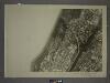
3A - N.Y. City (Aerial Set).
from Sectional aerial maps of the City of New York / [photographed and assembled under the direction of the chief engineer, July 1st, 1924].
Bronx, Topographical Map Sheet 7; [Map bounded by Inwood St., Hampden St., Macombs Road, Washington Bridge; Including 181 St., River St., Kingsbridge Broadway]
From Topographical map made from surveys by the commissioners of the Department of Public Parks of the City of New York of that part of Westchester County adjacent to the City and County of New York embraced by chapter 534 of laws of 1871 as amended b...
![Manhattan, V. 12, Plate No. 56 [Map bounded by Emerson Pl., Seaman Ave., Nicholas Place]](https://images-2.georeferencer.com/images/iiif/643924425553/full/,300/0/native.jpg)

