Maps of Bronx County

Manhattan, V. 12, Plate No. 52 [Map bounded by 10th Ave., W. 204th St., Harlem River, W. 201st St.]
From Atlas 129. Vol. 12, 1913.
Manhattan, V. 12, Plate No. 23 [Map bounded by W. 208th St., Harlem River, Academy St., Nagle Ave.]
From Atlas 128. Vol. 12, 1900.
Manhattan, V. 12, Plate No. 50 [Map bounded by 10th Ave., Dyckman St., Nagle Ave.]
From Atlas 129. Vol. 12, 1913.
Manhattan, V. 12, Plate No. 51 [Map bounded by Dyckman St., W. 201st St., Harlem River]
From Atlas 129. Vol. 12, 1913.
Manhattan, V. 12, Plate No. 60 [Map bounded by 10th Ave., W. 207th St., Harlem River, W. 204th St.]
From Atlas 129. Vol. 12, 1913.
Plate 185: Bounded by Nagle Avenue, Amsterdam Avenue, W. 208th Street, Harlem River and (Sherman's Creek) Academy Street.
from Atlas of the borough of Manhattan, city of New York.
Manhattan, V. 11 1/2, Double Page Plate No. 251 [Map bounded by W. 211st St., Harlem River, Dyckman St., Prescott Ave.]
From Atlas 42.61. Vol. 11-11 1/2, 1893.
Manhattan, V. 11 1/2, Double Page Plate No. 249 [Map bounded by Broadway, Harlem River, W. 187th St.]
From Atlas 42.61. Vol. 11-11 1/2, 1893.
Part of Section 8 : New York City.
from Atlas of the city of New York, borough of Manhattan. From actual surveys and official plans / by George W. and Walter S. Bromley.
22, ward 24.
1 : 1800 Bromley, George Washington; Bromley, Walter Scott; G.W. Bromley & Co.
Part of Section 8 : New York City.
from Atlas of the city of New York, borough of Manhattan. From actual surveys and official plans / by George W. and Walter S. Bromley.
Part of Section 8: Plate 180
from Atlas of the borough of Manhattan, city of New York.
Plate 56, Part of Section 11, Borough of the Bronx. [Bounded by W. 183rd Street, Aqueduct Avenue East, W. 181st Street, Harrison Avenue, W. 179th Street, Loring Place, W. 180th Street.]
from Atlas of borough of the Bronx, Sections 9 10 11 12 & 13 : from actual surveys and official plans / G.W. Bromley and Co.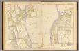
32, ward 24.
1 : 2400 Bromley, George Washington; Bromley, Walter Scott; G.W. Bromley & Co.
Manhattan, V. 12, Plate No. 14 [Map bounded by Academy St., Nagle Ave.]
From Atlas 128. Vol. 12, 1900.
Part of Section 8: Plate 184
from Atlas of the borough of Manhattan, city of New York.
Manhattan, V. 12, Plate No. 22 [Map bounded by Isham St., Nagle Ave., Academy St., Vermilyea Ave.]
From Atlas 128. Vol. 12, 1900.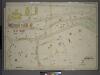
Double Page Plate No. 16, Part of Ward 24, Section 11. [Bounded by Exterior Street, Andrews Avenue and E. 177th Street.]
from Atlas of the borough of the Bronx, city of New York : based upon official plans and maps on file in the various city offices; supplemented by careful field measurements and personal observations, by and under the supervision of Hugo Ullitz.
Plate 188: Bounded by W. 214th Street, Columbus Avenue(Harlem River), W. 208th Street, Amsterdam Avenue, Ishan Street and Broadway.
from Atlas of the borough of Manhattan, city of New York.
Manhattan, V. 12, Plate No. 59 [Map bounded by W. 207th St., Nagle Ave., Academy St., Sherman Ave.]
From Atlas 129. Vol. 12, 1913.
Manhattan, V. 12, Plate No. 61 [Map bounded by 10th Ave., W. 210th St., Harlem River, W. 207th St.]
From Atlas 129. Vol. 12, 1913.
Manhattan, V. 12, Plate No. 48 [Map bounded by Dyckman St., Fort George Ave.]
From Atlas 129. Vol. 12, 1913.
Manhattan, V. 12, Plate No. 49 [Map bounded by Vermilyea Ave., Academy St., Nagle Ave., Dyckman St.]
From Atlas 129. Vol. 12, 1913.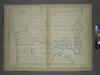
Page 25: [Bounded by W. 211th Street, Harlem Creek, W. 197th Street and Hudson River.]
from Sackersdorf Farm Set.
Fort Washington section.
From Manhattan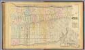
32. Ward 12.
1 : 3600 G.W. Bromley & Co.; Geo. W. Bromley & E. Robinson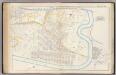
Pl. 45: ward 12.
1 : 3600 Bromley, George Washington; Bromley, Walter Scott
Sheet 20: [Bounded by 225th Street, (Spuyten Duyvel Creek Bulk Head Pier Line), 10th Avenue and 195th Street.]
from Plan of New York City, from the Battery to Spuyten Duyvil Creek. Showing every lot and building thereon; old farm lines, strreet numbers at the corners of blocks, railroads, steamboat landings, bulkhead and pier lines, etc. Based on the surveys made by Messrs. Randall & Blackwell, and on the special survey by J. F. Harrison.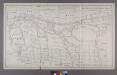
Map or Plan of Section 16. [Bounded by Burnside Avenue, Jerome Avenue, E. 184th Street, Walton Avenue, Morris Avenue and Kingsbridge Road.]
from Maps or plans and profiles, with field notes and explanatory remarks, showing the location, width, grades, and class of streets, roads, avenues, public squares and places, located and laid out by the Commissioner of Street Improvements of the 23rd and 24th wards of the city of New York : under authority of Chapter 545 of the laws of 1890.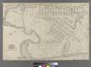
![Manhattan, V. 12, Plate No. 52 [Map bounded by 10th Ave., W. 204th St., Harlem River, W. 201st St.]](https://images-2.georeferencer.com/images/iiif/760931339999/full/,300/0/native.jpg)

