Maps of Bronx County

Manhattan, V. 12, Plate No. 42 [Map bounded by D. St., Dyckman St., Riverside Drive]
From Atlas 129. Vol. 12, 1913.
Manhattan, V. 12, Plate No. 41 [Map bounded by Riverside Drive, Broadway, Corbin Place]
From Atlas 129. Vol. 12, 1913.
Manhattan, V. 12, Plate No. 16 [Map bounded by Hudson River, Dyckman St., Broadway]
From Atlas 128. Vol. 12, 1900.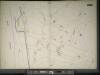
Manhattan, V. 11 1/2, Double Page Plate No. 252 [Map bounded by Bolton Rd., (Un-Named) Road, Hudson River]
From Atlas 42.61. Vol. 11-11 1/2, 1893.
Manhattan, V. 12, Plate No. 43 [Map bounded by Bolton Rd., Prescott Ave., Dyckman St.]
From Atlas 129. Vol. 12, 1913.
Manhattan, V. 12, Plate No. 44 [Map bounded by Prescott Ave., Academy St., Vermilyea Ave., Dyckman St.]
From Atlas 129. Vol. 12, 1913.
Manhattan, V. 12, Plate No. 45 [Map bounded by Dyckman St., Sherman Ave., Broadway]
From Atlas 129. Vol. 12, 1913.
Part of Section 8: Plate 181
from Atlas of the borough of Manhattan, city of New York.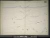
Manhattan, V. 11 1/2, Double Page Plate No. 250 [Map bounded by Hudson River, Dyckman St.]
From Atlas 42.61. Vol. 11-11 1/2, 1893.
Property identification map of Inwood Hill. [copy #1 Blue Print, 63 1/2" X 37"] [Copy # 2, Lithograph, Col., 69" X 42"]
From Manhattan
[Plate 49: Bounded by Harlem River (N.Y,C. & H.R.R.R.), Channel Line (U.S. Ship Canal), Prescott Avenue, Emerson Street, Isham Street, Seaman Avenue, Emerson Street, Broadway (Kingsbridge Road), and Dyckman Street.]
from Atlas of the city of New York, borough of Manhattan. From actual surveys and official plans / by George W. and Walter S. Bromley.
Part of Section 8 : New York City.
from Atlas of the city of New York, borough of Manhattan. From actual surveys and official plans / by George W. and Walter S. Bromley.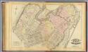
33. Ward 12.
1 : 3600 G.W. Bromley & Co.; Geo. W. Bromley & E. Robinson
Manhattan, V. 12, Plate No. 13 [Map bounded by Academy St., Nagle Ave., Broadway]
From Atlas 128. Vol. 12, 1900.
Plate 183: Bounded by Nicholas Place, Prescott Avenue, Emerson Place, W. 207th Street, Broadway and Dyckman Street.
from Atlas of the borough of Manhattan, city of New York.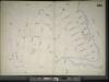
Manhattan, V. 11 1/2, Double Page Plate No. 251 [Map bounded by W. 211st St., Harlem River, Dyckman St., Prescott Ave.]
From Atlas 42.61. Vol. 11-11 1/2, 1893.
Part of Section 8: Plate 182
from Atlas of the borough of Manhattan, city of New York.
Manhattan, V. 12, Plate No. 15 [Map bounded by Hudson River, Broadway]
From Atlas 128. Vol. 12, 1900.
[Plate 178: Bounded by Riverside Drive (Hudson River), Corbin Place, Ft. Washington Avenue, Broadway, W. 192nd Street, Overlook Terrace and Northern Avenue. ]
from Atlas of the borough of Manhattan, city of New York.
Plate 179: Bounded by Broadway, Sherman Avenue, Dyckman Street, St Nicholas Avenue and Fairview Avenue.
from Atlas of the borough of Manhattan, city of New York.
Part of Section 8: Plate 184
from Atlas of the borough of Manhattan, city of New York.
Manhattan, V. 12, Plate No. 36 [Map bounded by Riverside Drive, Broadway]
From Atlas 129. Vol. 12, 1913.
Manhattan, V. 12, Plate No. 40 [Map bounded by Bolton Rd., Dyckman St.]
From Atlas 129. Vol. 12, 1913.
Manhattan, V. 12, Plate No. 55 [Map bounded by Bolton Rd., Nicholas Place]
From Atlas 129. Vol. 12, 1913.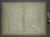
Page 25: [Bounded by W. 211th Street, Harlem Creek, W. 197th Street and Hudson River.]
from Sackersdorf Farm Set.
Fort Washington section.
From Manhattan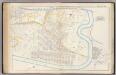
Pl. 45: ward 12.
1 : 3600 Bromley, George Washington; Bromley, Walter Scott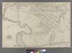
Part of Ward 12, New York City.
from Atlas of the city of New York : embracing all territory within its corporate limits from official records, private plans & actual surveys / by and under the supervision of E. Robinson & R.H. Pidgeon, civil engineers.
Plate 45: Bounded by Boulevard Lafayette (Hudson River), Harlem River ...
from Atlas of the city of New York, Manhattan Island. From actual surveys and official plans / by George W. and Walter S. Bromley.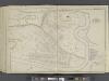
![Manhattan, V. 12, Plate No. 42 [Map bounded by D. St., Dyckman St., Riverside Drive]](https://images-2.georeferencer.com/images/iiif/345965912229/full/,300/0/native.jpg)

