Maps of Bergen County

Manhattan, V. 12, Plate No. 4 [Map bounded by W. 179th St., Fort Washington Ave., W. 175th St., Haven Ave.]
From Atlas 129. Vol. 12, 1913.
Manhattan, V. 12, Plate No. 1 [Map bounded by Hudson River, Fort Washington Ave., W. 170th St.]
From Atlas 128. Vol. 12, 1900.
Manhattan, V. 12, Plate No. 5 [Map bounded by W. 181st St., W. 175th St., Fort Washington Ave.]
From Atlas 128. Vol. 12, 1900.
Manhattan, V. 12, Plate No. 13 [Map bounded by W. 181st St., Northern Ave., W. 177th St., Riverside Drive]
From Atlas 129. Vol. 12, 1913.
Manhattan, V. 12, Plate No. 9 [Map bounded by Fort Washington Ave., W. 179th St., St. Nicholas Ave., W. 176th St.]
From Atlas 129. Vol. 12, 1913.
Manhattan, V. 12, Plate No. 3 [Map bounded by W. 175th St., Fort Washington Ave., W. 170th St., Haven Ave.]
From Atlas 129. Vol. 12, 1913.
Manhattan, V. 12, Plate No. 6 [Map bounded by Fort Washington Ave., W. 176th St., St. Nicholas Ave., W. 173rd St.]
From Atlas 129. Vol. 12, 1913.
Manhattan, V. 12, Plate No. 2 [Map bounded by Hudson River, Haven Ave.]
From Atlas 129. Vol. 12, 1913.
Manhattan, V. 12, Plate No. 14 [Map bounded by Northern Ave., W. 181st St., Broadway, W. 179th St.]
From Atlas 129. Vol. 12, 1913.
Part of Section 8: Plate 170
from Atlas of the borough of Manhattan, city of New York.
Manhattan, V. 12, Plate No. 2 [Map bounded by Hudson River, W. 181st St., Fort Washington Ave.]
From Atlas 128. Vol. 12, 1900.
Manhattan, V. 11 1/2, Double Page Plate No. 246 [Map bounded by Hudson River, W. 181st St., Fort Washington Ave.]
From Atlas 42.61. Vol. 11-11 1/2, 1893.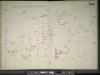
Manhattan, V. 11 1/2, Double Page Plate No. 245 [Map bounded by Fort Washington Ave., W. 181st St., Audubon Ave., W. 170th St.]
From Atlas 42.61. Vol. 11-11 1/2, 1893.
Page 23: [Bounded by W. 177th Street, Harlem River, w. 157th Street and Hudson River.]
from Maps of farms commonly called the Blue book, 1815 : drawn from the original on file in the street commissioner's office in the City of New York, together with lines of streets and avenues / laid out by John Randel, jr., 1819-20.
Plate 172: Bounded by W. 181st Street, Bennet Avenue, W. 184th Street, Broadway, W. 178th Street and (Fort Washington Park, Hudson River) Riverside Drive.
from Atlas of the borough of Manhattan, city of New York.
[Plate 168: Bounded by W. 173rd Street, St.Nicholas Avenue, W. 168th Street, ...(Harlem River, Fort Washington Park) Riverside Drive.]
from Atlas of the borough of Manhattan, city of New York.
Plate 171: Bounded by W. 178th Street, Amsterdam Avenue (Highbridge Park, Speedway), W. 173rd Street and Broadway.
from Atlas of the borough of Manhattan, city of New York.
Manhattan, V. 12, Plate No. 3 [Map bounded by W. 175th St., 11th Ave., W. 170th St., Fort Washington Ave.]
From Atlas 128. Vol. 12, 1900.
Manhattan, V. 12, Plate No. 9 [Map bounded by Hudson River, Broadway, W. 181st St.]
From Atlas 128. Vol. 12, 1900.
Manhattan, V. 12, Plate No. 11 [Map bounded by Hudson River, Riverside Drive]
From Atlas 129. Vol. 12, 1913.
Manhattan, V. 12, Plate No. 12 [Map bounded by Hudson River, Riverside Drive]
From Atlas 129. Vol. 12, 1913.
Manhattan, V. 12, Plate No. 5 [Map bounded by Fort Washington Ave., W. 173rd St., St. Nicholas Ave., W. 170th St.]
From Atlas 129. Vol. 12, 1913.
[Plate 47: Bounded by Harlem River, W. 182nd Street, W. 183rd Street, and Hudson River.]
from Atlas of the city of New York, borough of Manhattan. From actual surveys and official plans / by George W. and Walter S. Bromley.
Part of Section 8 : New York City.
from Atlas of the city of New York, borough of Manhattan. From actual surveys and official plans / by George W. and Walter S. Bromley.
Page 24: [Bounded by 199th Street, Harlem River, 177th Street and Hudson River.]
from Sackersdorf Farm Set.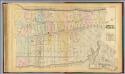
32. Ward 12.
1 : 3600 G.W. Bromley & Co.; Geo. W. Bromley & E. Robinson
Fort Washington section.
From Manhattan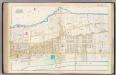
Pl. 44: ward 12.
1 : 3600 Bromley, George Washington; Bromley, Walter Scott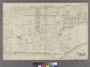
[Plate 31: Bounded by Harlem River, W. 166th Street, Hudson River...]
from Atlas of the city of New York : embracing all territory within its corporate limits from official records, private plans & actual surveys / by and under the supervision of E. Robinson & R.H. Pidgeon, civil engineers.
![Manhattan, V. 12, Plate No. 4 [Map bounded by W. 179th St., Fort Washington Ave., W. 175th St., Haven Ave.]](https://images-2.georeferencer.com/images/iiif/335083457811/full/,300/0/native.jpg)

