Maps of Kings County

Manhattan, V. 2, Plate No. 56 [Map bounded by East River, Marfinal St.]
From Atlas 110. Vol. 2, 1903.
Manhattan, V. 2, Plate No. 40 [Map bounded by E. 20th St., Avenue C, E. 15th St., Avenue B]
From Atlas 110. Vol. 2, 1903.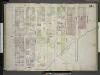
[Plate 45 1/2: Map bounded by Avenue A, East 22nd Street, East River, Avenue C, East 15th Street; Including Avenue B, East 16th Street, East 17th Street, East 18th Street, East 19th Street, East 20th Street, East 21st St]
from Insurance maps of the city of New York.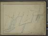
[Map bounded by Avenue B, Avenue A, E. 24th St, Bulkhead Line, E. 17th St; Including Avenue C, Tompkins St, E. 18th St, E. 19th St, E. 20th St, E. 21st St, E. 22nd St, E. 23rd St, Ferry to Greenpoint]
from Maps of the wharves & piers from the Battery to 61st street on the Hudson river and from the Battery to 41st street on the East river, New York. Surveyed by I.C. Buckhout, city surveyor.
[Plate 51: Bounded by E. 26th Street, East River [Piers 74-70], Exterior Street, E. 20th Street, and Second Avenue.]
from Atlas of the borough of Manhattan, city of New York.
Plate 42: Map bounded by East 20th Street, East River, East 17th Street, East River, East 15th Street, Avenue C, East 13th Street, Avenue A
from Maps of the city of New York.
Plate 11, Part of Section 3: [Bounded by E. 26th Street, First Avenue, E. 24th Street, Avenue A, E. 23rd Street, Exterior Street, E. 20th Street and Second Avenue.]
from Atlas of the city of New York, borough of Manhattan. From actual surveys and official plans / by George W. and Walter S. Bromley.
Plate 11, Part of Section 3: [Bounded by E. 26th Street, First Avenue, E. 24th Street, Avenue A, E. 21st Street, Avenue B, E. 20th Street and Second Avenue.]
from Atlas of the city of New York, borough of Manhattan. From actual surveys and official plans / by George W. and Walter S. Bromley.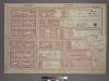
Plate 11, Part of Section 3: [Bounded by E. 26th Street, First Avenue, E. 24th Street, Avenue A, E. 21st Street, Avenue B, E. 20th Street and Second Avenue.]
from Atlas of the city of New York, borough of Manhattan. From actual surveys and official plans / by George W. and Walter S. Bromley.
[Plate 50: Map bounded by East 20th Street, East River, East 16th Street, Avenue C, East 13th Street, Avenue A.]
from Maps of the city of New York / surveyed under directions of insurance companies of said city.
Manhattan, V. 4, Double Page Plate No. 67 1/2 [Map bounded by East River, E. 22nd St., Avenue A]
From Atlas 42.54. Vol. 4, 1890.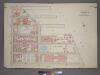
Plate 1, Part of Section 3: [Bounded by E. 20th Street, Avenue B, E. 14th Street and Avenue D.]
from Atlas of the city of New York, borough of Manhattan. From actual surveys and official plans / by George W. and Walter S. Bromley.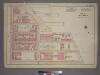
Plate 1, Part of Section 3: [Bounded by E. 20th Street, Avenue C (East River Piers), E. 15th Street, Avenue D, E. 14th Street and Avenue B.]
from Atlas of the city of New York, borough of Manhattan. From actual surveys and official plans / by George W. and Walter S. Bromley.
Part of Section 3 : Plate 46.
from Atlas of the borough of Manhattan, city of New York.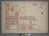
Plate 1, Part of Section 3: [Bounded by E. 20th Street, Avenue C (East River), E. 14th Street and Avenue B.]
from Atlas of the city of New York, borough of Manhattan. From actual surveys and official plans / by George W. and Walter S. Bromley.
Manhattan, V. 2, Plate No. 55 [Map bounded by East River, E. 15th St., Avenue E]
From Atlas 110. Vol. 2, 1903.
Plate 15: Bounded by E. 25th Street, Avenue A, E. 20th Street, Avenue B, E. 18th Street, Avenue C. E. 16th Street, Avenue D, E. 14th Street and Second Avenue.
from Atlas of the city of New York, Manhattan Island. From actual surveys and official plans / by George W. and Walter S. Bromley.
[Plate 15: Bounded by [Plate 32: Bounded by E. 25th Street, Exterior Street [East River], Avenue C, E. 14th Street, and Second Avenue.]
from Atlas of the city of New York, borough of Manhattan. From actual surveys and official plans / by George W. and Walter S. Bromley.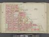
Manhattan, Double Page Plate No. 15 [Map bounded by E. 25th St., East River, E. 14th St., 2nd Ave.]
From Atlas of the city of New York, Manhattan Island. From actual surveys and official plans
7. Wards 11, 18.
1 : 2400 G.W. Bromley & Co.; Geo. W. Bromley & E. Robinson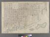
Part of Wards 11, 17 & 18, New York City.
from Atlas of the city of New York : embracing all territory within its corporate limits from official records, private plans & actual surveys / by and under the supervision of E. Robinson & R.H. Pidgeon, civil engineers.
Page 4: [Bounded by Luise Street (Kips Bay), East River, (Stuyvesant Square) E. Thirteenth Street, Third Avenue, Irving Place (Union Square) and Broadway.]
from Sackersdorf Farm Set.
Part of Section 2 : Plate 26
from Atlas of the borough of Manhattan, city of New York.
Map of the real estate in the city of New York : between the south side of Washington Parade, 4th St., and the north side of Bellevue, 28th Street / compiled from authentic documents by Edwin Smith, city surveyor, 1831 ; engd. by D.R. Harrison.
from Manhattan
Map showing the old farms : from 4th to 28th Street, east of 6th Avenue, New York / compiled from authentic documents by Edwin Smith, city surveyor, 1831.
from Manhattan
Sheet 10: [Bounded by E. Fortieth Street, First Avenue, E. Twentieth Street and Sixth Avenue.]
from Plan of New York City, from the Battery to Spuyten Duyvil Creek. Showing every lot and building thereon; old farm lines, strreet numbers at the corners of blocks, railroads, steamboat landings, bulkhead and pier lines, etc. Based on the surveys made by Messrs. Randall & Blackwell, and on the special survey by J. F. Harrison.
Sheet 8: [Bounded by 20th Street, Delancy Slip, Tompkins Street, Rivington Street and Avenue A.]
from Plan of New York City, from the Battery to Spuyten Duyvil Creek. Showing every lot and building thereon; old farm lines, strreet numbers at the corners of blocks, railroads, steamboat landings, bulkhead and pier lines, etc. Based on the surveys made by Messrs. Randall & Blackwell, and on the special survey by J. F. Harrison.
Sackersdorff Farm Set.
from Maps of farms commonly called the Blue book, 1815 : drawn from the original on file in the street commissioner's office in the City of New York, together with lines of streets and avenues / laid out by John Randel, jr., 1819-20.
Map of the city of New-York extending northward to Fiftieth St. / surveyed and drawn by John F. Harrison, C.E.
from Manhattan
![Manhattan, V. 2, Plate No. 56 [Map bounded by East River, Marfinal St.]](https://images-2.georeferencer.com/images/iiif/901769285300/full/,300/0/native.jpg)

