Maps of Kings County

Manhattan, V. 2, Plate No. 16 [Map bounded by Avenue D, E. 9th St., Tompkins St., 6th St.]
From Atlas 110. Vol. 2, 1903.
Plate 42: Map bounded by Eighth Street, East River, Third Street, Avenue D, Sixth Street, Avenue C.
from Maps of the city of New York / surveyed under directions of insurance companies of said city.
Manhattan, V. 2, Plate No. 53 [Map bounded by East River, Marginal St.]
From Atlas 110. Vol. 2, 1903.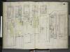
[Plate 34: Map bounded by Avenue D, Eighth Street, East River, Third Street; Including Lewis Street, Mangin Street, East Fourth Street, Fifth Street, Sixth Street, Seventh Street, Eighth Street; Map bounded by Avenue C, Eighth Street, Avenue
from Insurance maps of the city of New York.
Plate 34: Map bounded by 8th Street, East river, 3rd Street, Avenue D, 6th Street, Aventue C
from Maps of the city of New York.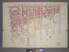
Plate 26, Part of Section 2: [Bounded by Columbia Street, Avenue D, E. 8th Street, Lewis Street, E. 4th Street, (East River Piers) Tompkins Street and Stanton Street.]
from Atlas of the city of New York, borough of Manhattan. From actual surveys and official plans / by George W. and Walter S. Bromley.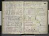
[Plate 38: Map bounded by East 13th Street, East River, Eighth Street, Avenue C; Including East 12th Street, East 11th Street, East 10th Street, East Ninth Street, Dry Dock Street, Avenue D]
from Insurance maps of the city of New York.
Manhattan, V. 2, Plate No. 15 [Map bounded by Avenue D, 6th St., Marginal St., E. 3rd St.]
From Atlas 110. Vol. 2, 1903.
Plate 46: Map bounded by East 15th Street, East River, Eighth Street, Avenue C.
from Maps of the city of New York / surveyed under directions of insurance companies of said city.
Plate 38: Map bounded by East 15th Street, East River, 8th Street, Avenue C
from Maps of the city of New York.
Manhattan, V. 2, Plate No. 24 [Map bounded by E. 13th St., East River, E. 9th St., Avenue D]
From Atlas 110. Vol. 2, 1903.
[Map bounded by Lewis Street, Avenue D, Avenue C, 14th St, Pier - Line 63-73, Houston Street; Including Williamsburgh Ferry, 3rd St, 4th St, 5th St, 6th St, 7th St, 8th St, 9th St, 10th St, Green Point Ferry, 11th St, 12th St, 13th St]
from Maps of the wharves and piers on the Hudson and East rivers from the Battery to 13th St., New York.
Plate 12: Bounded by E. 14th Street, Avenue D (East River, Piers 67-[73]), E. 8th Street, Lewis Street (East River, Piers 64-67), E. 3rd Street and First Avenue.
from Atlas of the city of New York, Manhattan Island. From actual surveys and official plans / by George W. and Walter S. Bromley.
Part of Sections 1 & 2 : New York City.
from Atlas of the city of New York, Manhattan Island. From actual surveys and official plans / by George W. and Walter S. Bromley.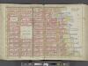
Manhattan, Double Page Plate No. 12 [Map bounded by E. 14th St., East River, E. 3rd St., 1st Ave.]
From Atlas of the city of New York, Manhattan Island. From actual surveys and official plans
[Plate 12: Bounded by E. 14th Street, Tompkins Street [East River, Piers 63-72], E. 3rd Street, and First Avenue.]
from Atlas of the city of New York, borough of Manhattan. From actual surveys and official plans / by George W. and Walter S. Bromley.
[Plate 7: Bounded by E. 3rd Street, [East River, Piers 60-64] Tompkins Street, [East River, Piers 55-60] East Street, Water Street, Corlears Street, Grand Street, Attorney Street, Essex Street, and Avenue A.]
from Atlas of the city of New York, borough of Manhattan. From actual surveys and official plans / by George W. and Walter S. Bromley.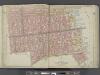
Manhattan, Double Page Plate No. 7 [Map bounded by E. 3rd St., East River, Grand St., Essex St.]
From Atlas of the city of New York, Manhattan Island. From actual surveys and official plans
7. Wards 11, 18.
1 : 2400 G.W. Bromley & Co.; Geo. W. Bromley & E. Robinson
[Plate 27: Bounded by E. 14th Street, East River, E. 8th Street, and Avenue B.]
from Atlas of the borough of Manhattan, city of New York.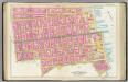
Pl. 7: wards 7, 10-11, 13, 17.
1 : 1800 Bromley, George Washington; Bromley, Walter Scott
Plate 27, Part of Section 2: [Bounded by E. 14th Street, (East River Piers) Avenue D, E. 8th Street and Avenue B.]
from Atlas of the city of New York, borough of Manhattan. From actual surveys and official plans / by George W. and Walter S. Bromley.
Manhattan, V. 4, Double Page Plate No. 20 [Map bounded by 7th St., East River, Stanton St., Ave. B]
From Vol. 4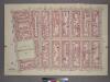
Plate 25, Part of Section 2: [Bounded by Clinton Street, Avenue B, E. 8th Street, Avenue D, Columbia Street and Stanton Street.]
from Atlas of the city of New York, borough of Manhattan. From actual surveys and official plans / by George W. and Walter S. Bromley.
[Map bounded by Avenue D, Avenue C, E. 17th St, Pier - Line, E. 10th St; Tompkins Street, Ferry to Greenpoint, E. 11th St, E. 12th St, E. 13th St, E. 14th St, E. 15th St, E. 16th St]
from Maps of the wharves & piers from the Battery to 61st street on the Hudson river and from the Battery to 41st street on the East river, New York. Surveyed by I.C. Buckhout, city surveyor.
[Plate 25: Bounded by Clinton Street, Avenue B, E. 8th Street, Avenue D, Columbia Street, and Stanton Street.]; Atlas of the borough of Manhattan, city of New York.
from Atlas of the borough of Manhattan, city of New York. G.W. Bromley & Co.,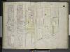
[Plate 42: Map bounded by Avenue A, East 15th Street, Avenue C, East 13th Street; Including East 14th Street; Map bounded by Avenue C, East River, East 13th Street; Including Avenue D, Tompkins Street, East 14th Street, East 15th Street, East 16th
from Insurance maps of the city of New York.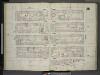
[Plate 35: Map bounded by Sixth Street, Avenue D, East Houston Street, Avenue C, Second Street, Avenue B; Including Fifth Street, East Fourth Street, Third Street, Sheriff Street]
from Insurance maps of the city of New York.
Plate 35: Map bounded by 6th Street, Avenue D, Houston Street, Pitt Street, 2nd Street, Avenue B
from Maps of the city of New York.
![Manhattan, V. 2, Plate No. 16 [Map bounded by Avenue D, E. 9th St., Tompkins St., 6th St.]](https://images-2.georeferencer.com/images/iiif/683404116997/full/,300/0/native.jpg)

