Maps of Manisa
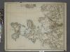
Sheet 8. 1: 250,000. / dressée par Henri Kiepert d'après ses propres observations et d'autres levées pour la plupart inédites = Map of the western part of Asia Minor
From Specialkarte vom westlichen Kleinasien nach seinen eigenen Reisen und anderen grösstenteils noch unveröffentlichten Routenaufnahmen bearbeitet von Heinrich Kiepert = Carte de la partie occidentale de l 'Asie mineure
Plán města Efesu podle Wooda

Plán města Efesu podle Wooda

Umgebung von Ephesos
1 : 25000 Efesos (zaniklé město) Schindler, A. des K. u. k. Militärgeographischen Institutes
Umgebung von Ephesos
1 : 25000 Efesos (zaniklé město) Schindler, A. des K. u. k. Militärgeographischen Institutes
Balkans 1 000 000e. Constantinople
1 : 1000000 France. Service géographique de l'armée [Paris] : Service géographique de l'armée
90. Anatolia occidentale, Isole Egee.
1 : 1500000 Touring club italiano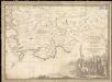
Parte dell'Asia Minore per servire di VI foglio della carta generale dell'Ungheria e della Turchia Europea
1 : 1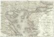
Carte de la Turquie d'Europe
1 : 1300000 Egejské moře-oblast Konrad, Al. Palma, Gaetano
Thracia Vetus
1 : 1100000 Mollova mapová sbírka Covens, Johannes Covens, Johannes I
Feuille No. 1, uit: Carte de la Turquie d'Asie (moins l'Arabie) / dessiné et héliogravé au Service géographique de l'Armée
1 : 1000000 titelvariant: Turquie d'Asie; Annotatie: Titel boven de kaart: Turquie d'Asie; Bl. genummerd 1-4 en 7-10; Met lijst van de meest gebruikte woorden op de kaart vertaald uit het Turks, Arabisch en Perzisch; Annotatie geografische gegevens: Inzetkrt. op bl. 9: Plan de Jérusalem et de ses environs, Plan d'Alep, Plan de Damas et de ses faubourgs, Plan de Beyrout et de ses environs (alle 1:50.000) Service géographique de l'Armée [S.l. : Service géographique de l'Armée]
Europ. Turkey IV.
1 : 1740000 Grassl, J. (Joseph)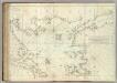
Carte De La Mer Mediterranee. XII.
Roux, Joseph
[Die Balkan-Halbinsel, Blatt 4]
Adolf Stieler's Handatlas über alle Theile der Erde und über das Weltgebäude Stieler, Adolf Justus Perthes
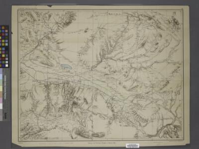
B2. Brussa. / bearbeitet von Richard Kiepert. 1902-1916.
From 1st Edition, 1:400,000. 1904-1907.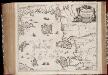
Insvlarvm Archipelagi Septentrionalis seu Maris Aegaei accurata delinatio / autore I. Laurenbergio
1 : 1100000 Annotatie: Jaar van uitg. van kaart ligt in de periode 1650-1662; Origineel is Blad 172 in atlas factice; Verso is blanco; Annotatie geografische gegevens: 4 schaalstokken op de kaart: 7 Mil. Germ., en: 10 Mil. Gall., en: 28 Mil. Ital., en 275 Stadia [Amstelodami] : [Apud Ioannem Ianssonium]
B2. Brussa. / bearbeitet von Richard Kiepert. 1902-1916.
From 2nd Edition. 1: 400,000. 1908-1914.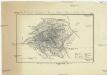
Topographische Skizze des Bulghar Dagh im cilicischen Taurus
1 : 250000 Taurus, pohoří (Turecko) Hotschy, Th.
Insularum Archipelagi Septentrionalis seu Maris Aegaei Accurata Delinatio [Karte], in: Novus atlas absolutissimus, Bd. 10, S. 219.
1 Karte aus Atlas Janssonius Offizin
MARIS ÆGÆI, | quod hodie | ARCHIPELAGO | nuncupatur, | PARS SEPTENTRIONALIS.
Auctore | IOANNE LAVRENBERGIO. [Amsterdam : Joan Blaeu]
Übersichtskarte von Mittel - Europa
Sheet 7. 1: 250,000. / dressée par Henri Kiepert d'après ses propres observations et d'autres levées pour la plupart inédites = Map of the western part of Asia Minor
From Specialkarte vom westlichen Kleinasien nach seinen eigenen Reisen und anderen grösstenteils noch unveröffentlichten Routenaufnahmen bearbeitet von Heinrich Kiepert = Carte de la partie occidentale de l 'Asie mineure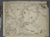
Sheet 5. 1: 250,000. / dressée par Henri Kiepert d'après ses propres observations et d'autres levées pour la plupart inédites = Map of the western part of Asia Minor
From Specialkarte vom westlichen Kleinasien nach seinen eigenen Reisen und anderen grösstenteils noch unveröffentlichten Routenaufnahmen bearbeitet von Heinrich Kiepert = Carte de la partie occidentale de l 'Asie mineure
Gallipoli, Brussa
1 : 750000 Bursa (Turecko) Gstettner, G. K. u. k. Militärgeographisches Institut
Gallipoli, Brussa
1 : 750000 Bursa (Turecko) K. k. militär-geographisches Institut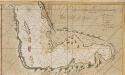
The Gulf of Smirna
Turkey Gerard van Keulen
[Europäische Türkey in IV Blättern]
Grosser Hand-Atlas über alle Theile der Erde in 170 Karten Meyer, J. Verlag des Bibliographischen Instituts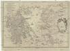
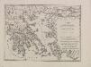
Carte de la Grece anciene
1 : 1250000 Řecko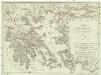
Carte von Griechenland
1 : 1250000 Řecko Votesky, M. Anville, Jean-Baptiste Bourguinon d' F.A. Schraembl