Maps of Queens County

Manhattan, V. 7, Plate No. 70 [Map bounded by Hudson River, Riverside Park]
From Atlas 120. Vol. 7, 1902.
Part of Sections 4 & 7 : Plate 98.
from Atlas of the borough of Manhattan, city of New York.
Manhattan, V. 7, Plate No. 71 [Map bounded by Hudson River, Riverside Park]
From Atlas 120. Vol. 7, 1902.
Manhattan, V. 7, Plate No. 17 [Map bounded by W. 96th St., W. End Ave., W. 91st St., Riverside Ave.]
From Atlas 120. Vol. 7, 1902.
Manhattan, V. 7, Plate No. 21 [Map bounded by W. 100th St., W. End Ave., W. 96th St., Riverside Ave.]
From Atlas 120. Vol. 7, 1902.
[Plate 36: Bounded by W. 97th Street, Central Park West, W. 86th Street, and [Hudson River, Riverside Park] Riverside Drive.]
from Atlas of the city of New York, borough of Manhattan. From actual surveys and official plans / by George W. and Walter S. Bromley.
Plate 36: Bounded by W. 97th Street, Central Park West, W. 86th Street, and (Hudson River) Riverside Drive.
from Atlas of the city of New York, Manhattan Island. From actual surveys and official plans / by George W. and Walter S. Bromley.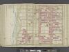
Manhattan, Double Page Plate No. 36 [Map bounded by W. 97th St., Central Park W., W. 86th St., Hudson St.,]
From Atlas of the city of New York, Manhattan Island. From actual surveys and official plans
25. Wards 12, 22.
1 : 2400 G.W. Bromley & Co.; Geo. W. Bromley & E. Robinson
Part of Wards 12 & 22, New York City.
from Atlas of the city of New York : embracing all territory within its corporate limits from official records, private plans & actual surveys / by and under the supervision of E. Robinson & R.H. Pidgeon, civil engineers.
Part of Section 4 : Plate 96.
from Atlas of the borough of Manhattan, city of New York.
[Plate 37: Bounded by W. 108th Street, Central Park West, W. 97th Street, and [Hudson River, Riverside Park] Riverside Drive.]
from Atlas of the city of New York, borough of Manhattan. From actual surveys and official plans / by George W. and Walter S. Bromley.
[Plate 37: Bounded by W. 108th Street, Central Park West, W. 97th Street and (Hudson River) Riverside Drive.]
from Atlas of the city of New York, Manhattan Island. From actual surveys and official plans / by George W. and Walter S. Bromley.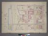
Plate 14, Part of Sections 4&7: [Bounded by W. 100th Street, Amsterdam Avenue, W. 95th Street and Riverside Drive.]
from Atlas of the city of New York, borough of Manhattan. From actual surveys and official plans / by George W. and Walter S. Bromley.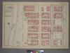
Plate 11, Part of Section 4: [Bounded by W. 95th Street, Amsterdam Avenue, W. 89th Street and (Riverside Park) Riverside Drive.]
from Atlas of the city of New York, borough of Manhattan. From actual surveys and official plans / by George W. and Walter S. Bromley.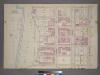
Plate 11, Part of Section 4: [Bounded by W. 95th Street, Amsterdam Avenue, W. 89th Street and (Hudson River - Riverside Park) Riverside Drive.]
from Atlas of the city of New York, borough of Manhattan. From actual surveys and official plans / by George W. and Walter S. Bromley.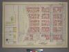
Plate 14, Part of Sections 4&7: [Bounded by W. 100th Street, Amsterdam Avenue, W. 95th Street and (Riverside Park) Riverside Drive.]
from Atlas of the city of New York, borough of Manhattan. From actual surveys and official plans / by George W. and Walter S. Bromley.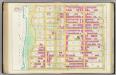
Pl. 36: ward 12.
1 : 1800 Bromley, George Washington; Bromley, Walter Scott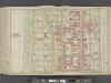
Manhattan, Double Page Plate No. 37 [Map bounded by W. 108th St., Central Park W., W. 97th St., Hudson River]
From Atlas of the city of New York, Manhattan Island. From actual surveys and official plans
[Plate 100: Bounded by W. 105th Street, Amsterdam Avenue, W. 100th Street,and [Hudson River, Riverside Park] Riverside Drive.]
from Atlas of the borough of Manhattan, city of New York.
Manhattan, V. 7, Plate No. 72 [Map bounded by Hudson River, Riverside Park]
From Atlas 120. Vol. 7, 1902.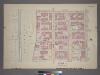
Plate 15, Part of Section 7: [Bounded by W. 105th Street, Amsterdam Avenue, W. 100th Street and (Hudson River - Riverside Park) Riverside Drive.]
from Atlas of the city of New York, borough of Manhattan. From actual surveys and official plans / by George W. and Walter S. Bromley.
Manhattan, V. 7, Plate No. 18 [Map bounded by W. 96th St., Amsterdam Ave., W. 91st St., W. End Ave.]
From Atlas 120. Vol. 7, 1902.
Manhattan, V. 7, Plate No. 13 [Map bounded by W. 91st St., W. End Ave., W. 86th St., Riverside Ave.]
From Atlas 120. Vol. 7, 1902.
Sheet 15: [Bounded by [W. Hundred & Twenty Fourth Street], 6th Avenue, W. Hundred & Ninteenth Street, 5th Avenue, Central Park, [W. Ninety Second Street] and 12th Avenue.]
from Plan of New York City, from the Battery to Spuyten Duyvil Creek. Showing every lot and building thereon; old farm lines, strreet numbers at the corners of blocks, railroads, steamboat landings, bulkhead and pier lines, etc. Based on the surveys made by Messrs. Randall & Blackwell, and on the special survey by J. F. Harrison.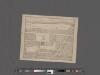
[Plan of Morningside Park.]
From Manhattan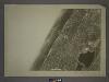
5D - N.Y. City (Aerial Set).
from Sectional aerial maps of the City of New York / [photographed and assembled under the direction of the chief engineer, July 1st, 1924].
Data for population from census of 1910, Borough of Manhattan
From Manhattan
Height District Map Section No. 5; Height district map / City of New York, Board of Estimate and Apportionment.
from Height district map / City of New York, Board of Estimate and Apportionment. New York (N.Y.). Board of Estimate and Apportionment,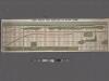
![Manhattan, V. 7, Plate No. 70 [Map bounded by Hudson River, Riverside Park]](https://images-2.georeferencer.com/images/iiif/759581297923/full/,300/0/native.jpg)

