Maps of Manhattan Community Board 9

Manhattan, V. 7, Plate No. 63 [Map bounded by Riverside Ave., W. 129th St., W. 127th St.]
From Atlas 120. Vol. 7, 1902.
Manhattan, V. 7, Plate No. 62 [Map bounded by Hudson River, W. 130th St., Broadway, W. 126th St.]
From Atlas 120. Vol. 7, 1902.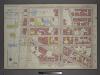
Plate 19: Part of Section 7.
from Atlas of the city of New York, borough of Manhattan / from actual surveys and official plans by George W. and Walter S. Bromley.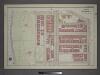
[Plate 18: Bounded by W. 127th Street, Manhattan Street, Amsterdam Avenue, W. 122nd Street and (Riverside Park) Riverside Drive.]
from Atlas of the city of New York, borough of Manhattan / from actual surveys and official plans by George W. and Walter S. Bromley.
Part of Section 7: Plate 138
from Atlas of the borough of Manhattan, city of New York.
Part of Section 7: Plate 144
from Atlas of the borough of Manhattan, city of New York.
Manhattan, V. 7, Plate No. 75 [Map bounded by Hudson River, Riverside Park, W. 129th St.]
From Atlas 120. Vol. 7, 1902.
Part of Section 7: Plate 149
from Atlas of the borough of Manhattan, city of New York.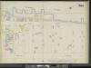
Manhattan, V. 11, Double Page Plate No. 244 [Map bounded by Hudson River, W. 138th St., Boulevard, W. 130th St.]
From Atlas 42.61. Vol. 11-11 1/2, 1893.
Manhattan, V. 7, Plate No. 59 [Map bounded by W. 130th St., Amsterdam Ave., W. 125th St., Broadway]
From Atlas 120. Vol. 7, 1902.
Manhattan, V. 7, Plate No. 61 [Map bounded by Hudson River, Broadway, W. 122nd St.]
From Atlas 120. Vol. 7, 1902.
Manhattan, V. 7, Plate No. 76 [Map bounded by Hudson River, 12th Ave., W. 129th St.]
From Atlas 120. Vol. 7, 1902.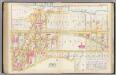
Pl. 39: ward 12.
1 : 1800 Bromley, George Washington; Bromley, Walter Scott
Part of Section 7: New York City.
from Atlas of the city of New York, Manhattan Island. From actual surveys and official plans / by George W. and Walter S. Bromley.
[Plate 39: Bounded by Twelfth Avenue (Hudson River), Riverside Drive, W. 142nd Street, 10th Avenue, W. 141st Street, Convent Avenue, and W. 125th Street.]
from Atlas of the city of New York, borough of Manhattan. From actual surveys and official plans / by George W. and Walter S. Bromley.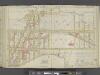
Manhattan, Double Page Plate No. 39 [Map bounded by Hudson River, W.124th St., Convent Ave., W. 125th St.]
From Atlas of the city of New York, Manhattan Island. From actual surveys and official plans
29. Ward 12.
1 : 2400 G.W. Bromley & Co.; Geo. W. Bromley & E. Robinson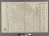
Blackwell's Island.
from Atlas of the city of New York : embracing all territory within its corporate limits from official records, private plans & actual surveys / by and under the supervision of E. Robinson & R.H. Pidgeon, civil engineers.
30. Ward 12.
1 : 3600 G.W. Bromley & Co.; Geo. W. Bromley & E. Robinson
Page 21: [Bounded by W. 156th Street, (Hamilton Heights) Ninth Avenue, W. 136th Street and North River.]
from Sackersdorf Farm Set.
Page 18: [Bounded by W. 135th Street, Eighth Avenue, W. 115th Street and (Morningside Heights) Hudson River.]
from Sackersdorf Farm Set.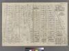
Part of Ward 12, New York City.
from Atlas of the city of New York : embracing all territory within its corporate limits from official records, private plans & actual surveys / by and under the supervision of E. Robinson & R.H. Pidgeon, civil engineers.
Sheet 15: [Bounded by [W. Hundred & Twenty Fourth Street], 6th Avenue, W. Hundred & Ninteenth Street, 5th Avenue, Central Park, [W. Ninety Second Street] and 12th Avenue.]
from Plan of New York City, from the Battery to Spuyten Duyvil Creek. Showing every lot and building thereon; old farm lines, strreet numbers at the corners of blocks, railroads, steamboat landings, bulkhead and pier lines, etc. Based on the surveys made by Messrs. Randall & Blackwell, and on the special survey by J. F. Harrison.
Sheet 17: [Bounded by 158th Street, 10th Avenue, 155th Street, 8th Avenue, 154th Street, 7th Avenue, 149th Street, 6th Avenue, W. Hundred & Twenty Fifth Street, and (Audubon Park) 11th Avenue.]
from Plan of New York City, from the Battery to Spuyten Duyvil Creek. Showing every lot and building thereon; old farm lines, strreet numbers at the corners of blocks, railroads, steamboat landings, bulkhead and pier lines, etc. Based on the surveys made by Messrs. Randall & Blackwell, and on the special survey by J. F. Harrison.
[Plan of Morningside Park.]
From Manhattan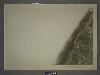
5B - N.Y. City (Aerial Set).
from Sectional aerial maps of the City of New York / [photographed and assembled under the direction of the chief engineer, July 1st, 1924].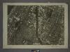
6A - N.Y. City (Aerial Set).
from Sectional aerial maps of the City of New York / [photographed and assembled under the direction of the chief engineer, July 1st, 1924].
Height District Map Section No. 5; Height district map / City of New York, Board of Estimate and Apportionment.
from Height district map / City of New York, Board of Estimate and Apportionment. New York (N.Y.). Board of Estimate and Apportionment,
Proposed Harlem River Drive from 155th Street to Dyckman River.
From Manhattan
![Manhattan, V. 7, Plate No. 63 [Map bounded by Riverside Ave., W. 129th St., W. 127th St.]](https://images-2.georeferencer.com/images/iiif/956181557390/full/,300/0/native.jpg)

