Maps of Manhattan Community Board 9

Manhattan, V. 7, Plate No. 34 [Map bounded by Hudson River, W. 116th St., Broadway, W. 113th St.]
From Atlas 120. Vol. 7, 1902.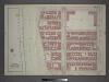
Plate 6: Part of Section 7.
from Atlas of the city of New York, borough of Manhattan / from actual surveys and official plans by George W. and Walter S. Bromley.
Manhattan, V. 7, Plate No. 74 [Map bounded by Hudson River, Riverside Park]
From Atlas 120. Vol. 7, 1902.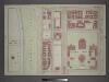
Plate 7: Part of Section 7.
from Atlas of the city of New York, borough of Manhattan / from actual surveys and official plans by George W. and Walter S. Bromley.
Manhattan, V. 7, Plate No. 41 [Map bounded by Hudson River, W. 119th St., Broadway, W. 116th St.]
From Atlas 120. Vol. 7, 1902.
Manhattan, V. 7, Plate No. 33 [Map bounded by Hudson River, W. 113th St., Broadway, Cathedral Parkway]
From Atlas 120. Vol. 7, 1902.
Manhattan, V. 7, Plate No. 73 [Map bounded by Hudson River, Riverside Park]
From Atlas 120. Vol. 7, 1902.
Manhattan, V. 7, Plate No. 35 [Map bounded by W. 115th St., Amsterdam Ave., Cathedral Parkway, Broadway]
From Atlas 120. Vol. 7, 1902.
Manhattan, V. 7, Plate No. 43 [Map bounded by W. 120th St., Amsterdam Ave., W. 115th St., Broadway]
From Atlas 120. Vol. 7, 1902.
Plate 132: Bounded by W. 122nd Street, Amsterdam Avenue, W. 116th Street and (Harlem River) Riverside Drive.
from Atlas of the borough of Manhattan, city of New York.
Plate 126: Bounded by W. 116th Street, Amsterdam Avenue, Cathedral Parkway and (Hudson River) Riverside Drive.
from Atlas of the borough of Manhattan, city of New York.
Plate 38: Bounded by (Hudson River) Riverside Park/Drive, W. 125th Street, 9th Avenue, W. 123rd Street, 10th Avenue, Morningside Avenue, Columbus [Avenue] and W. 108th Street.
from Atlas of the city of New York, Manhattan Island. From actual surveys and official plans / by George W. and Walter S. Bromley.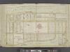
Manhattan, Double Page Plate No. 38 [Map bounded by Hudson River, W. 125th St., 9th Ave., W.1 08th St.]
From Atlas of the city of New York, Manhattan Island. From actual surveys and official plans
[Plate 38: Bounded by Hudson River (Riverside Park, Riverside Drive), W. 125th Street, Morningside Drive, Columbus Avenue, and W. 108th Street.]
from Atlas of the city of New York, borough of Manhattan. From actual surveys and official plans / by George W. and Walter S. Bromley.
Pl. 38: ward 12.
1 : 1800 Bromley, George Washington; Bromley, Walter Scott
Map of Morningside Park.
From Manhattan
Preliminary Study for the Design of Morningside Park [1873].
From Manhattan
Revised general plan for Morningside Park, to accompany report by Frederick Law Olmsted and Calvert Vaux . . . September 28th, 1887.
From Manhattan
Plate 102: Bounded by Cathedral Parkway, Amsterdam Avenue, W. 105th Street and (Riverside Park) Riverside Drive.
from Atlas of the borough of Manhattan, city of New York.
Plate 18, Part of Section 7: [Bounded by Cathedral Parkway, Amsterdam Avenue, W. 105th Street and (Hudson River - Riverside Park) Riverside Drive.]
from Atlas of the city of New York, borough of Manhattan. From actual surveys and official plans / by George W. and Walter S. Bromley.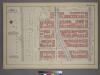
Plate 18, Part of Section 7: [Bounded by Cathedral Parkway, Amsterdam Avenue, W. 105th Street and (Riverside Park) Riverside Drive.]
from Atlas of the city of New York, borough of Manhattan. From actual surveys and official plans / by George W. and Walter S. Bromley.
Manhattan, V. 7, Plate No. 42 [Map bounded by Hudson River, W. 122nd St., Broadway, W. 119th St.]
From Atlas 120. Vol. 7, 1902.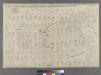
Part of Ward 12, New York City.
from Atlas of the city of New York : embracing all territory within its corporate limits from official records, private plans & actual surveys / by and under the supervision of E. Robinson & R.H. Pidgeon, civil engineers.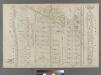
Blackwell's Island.
from Atlas of the city of New York : embracing all territory within its corporate limits from official records, private plans & actual surveys / by and under the supervision of E. Robinson & R.H. Pidgeon, civil engineers.
Page 18: [Bounded by W. 135th Street, Eighth Avenue, W. 115th Street and (Morningside Heights) Hudson River.]
from Sackersdorf Farm Set.
Sackersdorff Farm set.
from Maps of farms commonly called the Blue book, 1815 : drawn from the original on file in the street commissioner's office in the City of New York, together with lines of streets and avenues / laid out by John Randel, jr., 1819-20.
Sheet 15: [Bounded by [W. Hundred & Twenty Fourth Street], 6th Avenue, W. Hundred & Ninteenth Street, 5th Avenue, Central Park, [W. Ninety Second Street] and 12th Avenue.]
from Plan of New York City, from the Battery to Spuyten Duyvil Creek. Showing every lot and building thereon; old farm lines, strreet numbers at the corners of blocks, railroads, steamboat landings, bulkhead and pier lines, etc. Based on the surveys made by Messrs. Randall & Blackwell, and on the special survey by J. F. Harrison.
Sheet 17: [Bounded by 158th Street, 10th Avenue, 155th Street, 8th Avenue, 154th Street, 7th Avenue, 149th Street, 6th Avenue, W. Hundred & Twenty Fifth Street, and (Audubon Park) 11th Avenue.]
from Plan of New York City, from the Battery to Spuyten Duyvil Creek. Showing every lot and building thereon; old farm lines, strreet numbers at the corners of blocks, railroads, steamboat landings, bulkhead and pier lines, etc. Based on the surveys made by Messrs. Randall & Blackwell, and on the special survey by J. F. Harrison.
[Plan of Morningside Park.]
From Manhattan
![Manhattan, V. 7, Plate No. 34 [Map bounded by Hudson River, W. 116th St., Broadway, W. 113th St.]](https://images-2.georeferencer.com/images/iiif/865705757951/full/,300/0/native.jpg)

