Maps of Queens County

Manhattan, V. 8, Double Page Plate No. 175 [Map bounded by 3rd Ave., E. 124th St., 1st Ave., E. 117th St.]
From Atlas 122. Vol. 8, 1896.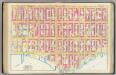
Pl. 33: ward 12
1 : 1800 Bromley, George Washington; Bromley, Walter Scott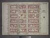
Plate 11: Part of Section 6.
from Atlas of the city of New York, borough of Manhattan / from actual surveys and official plans by George W. and Walter S. Bromley.
Part of Section 6: Plate 136
from Atlas of the borough of Manhattan, city of New York.
Part of Section 6: Plate 137
from Atlas of the borough of Manhattan, city of New York.
[Plate 142: Bounded by E. 127th Street, Second Avenue, E. 122nd Street and Park Avenue.]
from Atlas of the borough of Manhattan, city of New York.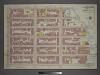
Plate 12: Part of Section 6.
from Atlas of the city of New York, borough of Manhattan / from actual surveys and official plans by George W. and Walter S. Bromley.
Part of Section 6: Plate 143
from Atlas of the borough of Manhattan, city of New York.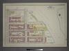
Plate 13: Part of Section 6.
from Atlas of the city of New York, borough of Manhattan / from actual surveys and official plans by George W. and Walter S. Bromley.
Manhattan, V. 8, Double Page Plate No. 176 [Map bounded by 1st Ave., E. 126th St., Harlem River, E. 118th St.]
From Atlas 122. Vol. 8, 1896.
Manhattan, V. 8, Double Page Plate No. 177 [Map bounded by 3rd Ave., Harlem River, 1st Ave., E. 124th St.]
From Atlas 122. Vol. 8, 1896.
Manhattan, V. 8, Double Page Plate No. 171 [Map bounded by 3rd Ave., E. 117th St., 1st Ave., E. 110th St.]
From Atlas 122. Vol. 8, 1896.
Manhattan, V. 8, Double Page Plate No. 174 [Map bounded by E. 125th St., 3rd Ave., E. 120th St., Portion of Mount Morris Sq., 5th Ave.]
From Atlas 122. Vol. 8, 1896.
Manhattan, V. 8, Double Page Plate No. 173 [Map bounded by E. 120th St., 3rd Ave., E. 115th St., 5th Ave.]
From Atlas 122. Vol. 8, 1896.
24. Ward 12.
1 : 2400 G.W. Bromley & Co.; Geo. W. Bromley & E. Robinson
Part of Section 6 : New York City.
from Atlas of the city of New York, Manhattan Island. From actual surveys and official plans / by George W. and Walter S. Bromley.
Part of Section 6 : New York City.
from Atlas of the city of New York, borough of Manhattan. From actual surveys and official plans / by George W. and Walter S. Bromley.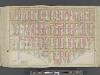
Manhattan, Double Page Plate No. 33 [Map bounded by 3rd Ave., E. 125th St., East River, E. 108thSt.]
From Atlas of the city of New York, Manhattan Island. From actual surveys and official plans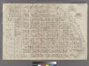
Part of Ward 12, New York City.
from Atlas of the city of New York : embracing all territory within its corporate limits from official records, private plans & actual surveys / by and under the supervision of E. Robinson & R.H. Pidgeon, civil engineers.
Sackersdorff Farm set.
from Sackersdorf Farm Set.
Sackersdorff Farm set.
from Maps of farms commonly called the Blue book, 1815 : drawn from the original on file in the street commissioner's office in the City of New York, together with lines of streets and avenues / laid out by John Randel, jr., 1819-20.
Plate 5: Map No. 375 [Bounded by Fourth Avenue, Riverside Avenue, Macomb Avenue, Cottage Street, Morris Avenue, 3rd Avenue and 129th Street.] - Map No. 213 [Bounded by Cherry Street, Old Harlem Bridge Post Road from New York to Boston, Harlem River and N
from Certified copies of important maps appertaining to the 23rd and 24th wards, City of New York, filed in the Register's office at White Plains, County of Westchester, New York ...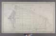
Section 1 of Final Maps and Profiles, of the 23rd & 24th Wards.
from Maps or plans and profiles, with field notes and explanatory remarks, showing the location, width, grades, and class of streets, roads, avenues, public squares and places, located and laid out by the Commissioner of Street Improvements of the 23rd and 24th wards of the city of New York : under authority of Chapter 545 of the laws of 1890.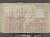
Manhattan, Double Page Plate No. 34 [Map bounded by Lenox Ave., E. 125th St., 3rd Ave., E. 108th St.]
From Atlas of the city of New York, Manhattan Island. From actual surveys and official plans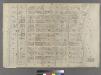
[Plate 22: Bounded by E. 115th Street, East River (Pleasant Avenue), E. 102nd Street and Fifth Avenue.]
from Atlas of the city of New York : embracing all territory within its corporate limits from official records, private plans & actual surveys / by and under the supervision of E. Robinson & R.H. Pidgeon, civil engineers.
[Plate 34: Bounded by Lenox Avenue (6th Ave.), W. 125th Street, E. 125th Street, Third Avenue, E. 108th Street, and W. 110th Street.]
from Atlas of the city of New York, borough of Manhattan. From actual surveys and official plans / by George W. and Walter S. Bromley.
[Plate 34: Bounded by Lenox Avenue, W. 125th Street, Third Avenue, E. 108th Street, Fifth Avenue and (Central Park) W. 110th Street.]
from Atlas of the city of New York, Manhattan Island. From actual surveys and official plans / by George W. and Walter S. Bromley.
[Plate 41: Bounded by E. 136th Street, Harlem River, First Avenue, E. 125th Street, and Fifth Avenue.]
from Atlas of the city of New York, borough of Manhattan. From actual surveys and official plans / by George W. and Walter S. Bromley.
Part of Section 6: New York City.
from Atlas of the city of New York, Manhattan Island. From actual surveys and official plans / by George W. and Walter S. Bromley.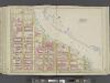
![Manhattan, V. 8, Double Page Plate No. 175 [Map bounded by 3rd Ave., E. 124th St., 1st Ave., E. 117th St.]](https://images-2.georeferencer.com/images/iiif/860939551780/full/,300/0/native.jpg)

