Maps of Queens County
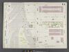
Manhattan, V. 6, Double Page Plate No. 114 [Map bounded by W. 67th St., Amsterdam Ave., W. 62nd St., 12th Ave.]
From Atlas 117. Vol. 6, 1892.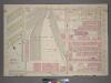
Plate 2, Part of Section 4: [Bounded by W. 65th Street,Amsterdam Avenue, W. 59th Street and (N.Y.C. & H.R.R.C.R. Union Stock Yards) West End Avenue.]
from Atlas of the city of New York, borough of Manhattan. From actual surveys and official plans / by George W. and Walter S. Bromley.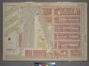
Plate 2, Part of Section 4: [Bounded by W. 65th Street, Amsterdam Avenue, W. 59th Street and (Hudson River Piers) West End Avenue.]
from Atlas of the city of New York, borough of Manhattan. From actual surveys and official plans / by George W. and Walter S. Bromley.
Plate 114: Map bounded by West 64th Street, Tenth Avenue, West 57th Street, Hudson River
from Maps of the city of New York.
Part of Section 4 : Plate 86.
from Atlas of the borough of Manhattan, city of New York.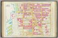
Pl. 25: ward 22.
1 : 1800 Bromley, George Washington; Bromley, Walter Scott
Part of Section 4 : Plate 88.
from Atlas of the borough of Manhattan, city of New York.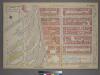
Plate 3, Part of Section 4: [Bounded by W. 71st Street, Amsterdam Avenue, W. 65th Street and (Hudson River Piers) West End Avenue.]
from Atlas of the city of New York, borough of Manhattan. From actual surveys and official plans / by George W. and Walter S. Bromley.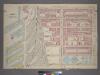
Plate 3, Part of Section 4: [Bounded by W. 71st Street,Amsterdam Avenue, W. 65th Street and (NewYork Central & Hudson River Rail Road Co.) West End Avenue.]
from Atlas of the city of New York, borough of Manhattan. From actual surveys and official plans / by George W. and Walter S. Bromley.
Plate 115: Map bounded by West 72nd Street, Tenth Avenue, West 64th Street, Hudson River
from Maps of the city of New York.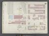
Manhattan, V. 6, Double Page Plate No. 113 [Map bounded by W. 62nd St., 10th Ave., W. 57th St., 12th Ave.]
From Atlas 117. Vol. 6, 1892.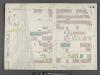
Manhattan, V. 6, Double Page Plate No. 115 [Map bounded by W. 72nd St., Amsterdam Ave., W. 67th St., 12th Ave.]
From Atlas 117. Vol. 6, 1892.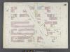
Manhattan, V. 6, Double Page Plate No. 116 [Map bounded by W. 67th St., Central Park West, W. 62nd St., Amsterdam Ave.]
From Atlas 117. Vol. 6, 1892.
Plate 116: Map bounded by West 67th Street, Eighth Avenue, West 62nd Street, Tenth Avenue
from Maps of the city of New York.
[Plate 25: Bounded by W. 75th Street, Central Park West (8th Avenue), W. 64th Street and (Hudson River) Twelfth Avenue.]
from Atlas of the city of New York, Manhattan Island. From actual surveys and official plans / by George W. and Walter S. Bromley.
[Plate 25: Bounded by W. 75th Street, Central Park West (8th Avenue), W. 64th Street, [Hudson River Piers E-I], W. 72nd Street, and Riverside Avenue.]
from Atlas of the city of New York, borough of Manhattan. From actual surveys and official plans / by George W. and Walter S. Bromley.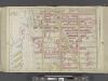
Manhattan, Double Page Plate No. 25 [Map bounded by W. 75th St., Central Park W., W. 64th St., Hudson River]
From Atlas of the city of New York, Manhattan Island. From actual surveys and official plans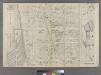
Part of Ward 22, New York City.
from Atlas of the city of New York : embracing all territory within its corporate limits from official records, private plans & actual surveys / by and under the supervision of E. Robinson & R.H. Pidgeon, civil engineers.
Sackersdorff Farm Set.
from Maps of farms commonly called the Blue book, 1815 : drawn from the original on file in the street commissioner's office in the City of New York, together with lines of streets and avenues / laid out by John Randel, jr., 1819-20.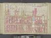
Manhattan, Double Page Plate No. 24 [Map bounded by Hudson River, W. 64th St., 9th Ave., W. 47th St.]
From Atlas of the city of New York, Manhattan Island. From actual surveys and official plans
Part of Section 4 : New York City.
from Atlas of the city of New York, Manhattan Island. From actual surveys and official plans / by George W. and Walter S. Bromley.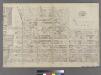
Part of Ward 22, New York City.
from Atlas of the city of New York : embracing all territory within its corporate limits from official records, private plans & actual surveys / by and under the supervision of E. Robinson & R.H. Pidgeon, civil engineers.
Central Park
from Manhattan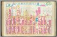
Pl. 24: ward 22.
1 : 1800 Bromley, George Washington; Bromley, Walter Scott
[Plate 22: Bounded by Sixth Avenue, Central Park South, Fifth Avenue, E. 64th Street, Lexington Avenue, and E. 47th Street.]
from Atlas of the city of New York, borough of Manhattan. From actual surveys and official plans / by George W. and Walter S. Bromley.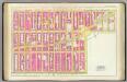
Pl. 23: ward 22.
1 : 1800 Bromley, George Washington; Bromley, Walter Scott
Manhattan, V. 6, Double Page Plate [Map of Hudson River Piers along 12th Ave.]
From Atlas 117. Vol. 6, 1892.
[Plate 24: Bounded by Twelfth Avenue [Hudson River Piers], W. 60th Street, West End Avenue, W. 64th Street, Columbus Avenue, and W. 47th Street.]
from Atlas of the city of New York, borough of Manhattan. From actual surveys and official plans / by George W. and Walter S. Bromley.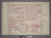
Plate 4, Part of Section 4: [Bounded by W. 77th Street, Central Park West, W. 65th Street and Amsterdam Avenue.]
from Atlas of the city of New York, borough of Manhattan. From actual surveys and official plans / by George W. and Walter S. Bromley.
![Manhattan, V. 6, Double Page Plate No. 114 [Map bounded by W. 67th St., Amsterdam Ave., W. 62nd St., 12th Ave.]](https://images-2.georeferencer.com/images/iiif/439857875763/full/,300/0/native.jpg)

