Maps of Queens County
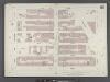
Manhattan, V. 6, Double Page Plate No. 112 [Map bounded by W. 62nd St., Central Park West, 8th Ave., W. 57th St., 10th Ave.]
From Atlas 117. Vol. 6, 1892.
Plate 113: Map bounded by West 62nd Street, Eighth Avenue, West 57th Street, Tenth Avenue
from Maps of the city of New York.
Part of Section 4 : Plate 87.
from Atlas of the borough of Manhattan, city of New York.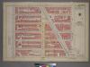
Plate 1, Part of Section 4: [Bounded by W. 65th Street, Central Park West, W. 59th Street and Amsterdam Avenue.]
from Atlas of the city of New York, borough of Manhattan. From actual surveys and official plans / by George W. and Walter S. Bromley.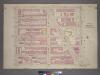
Plate 1, Part 1 of Section 4: [Bounded by W. 65th Street, Central Park West, W. 59th Street and Amsterdam Avenue.]
from Atlas of the city of New York, borough of Manhattan. From actual surveys and official plans / by George W. and Walter S. Bromley.
Manhattan, V. 6, Plate No. 35 [Map bounded by 8th Ave., Central Park South, 7th Ave., W. 58th St.]
From Atlas 118. Vol. 6, 1907.
[Plate 81: Bounded by W. 59th Street, Ninth Avenue, W. 53rd Street, and Eleventh Avenue.]
from Atlas of the borough of Manhattan, city of New York.
[Plate 24: Bounded by Twelfth Avenue [Hudson River Piers], W. 60th Street, West End Avenue, W. 64th Street, Columbus Avenue, and W. 47th Street.]
from Atlas of the city of New York, borough of Manhattan. From actual surveys and official plans / by George W. and Walter S. Bromley.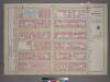
Plate 41, Part of Section 3: [Bounded by W. 59th Street, Ninth Avenue, W. 53rd Street and Eleventh Avenue.]
from Atlas of the city of New York, borough of Manhattan. From actual surveys and official plans / by George W. and Walter S. Bromley.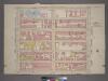
Plate 41, Part of Section 4: [Bounded by W. 59th Street, Ninth Avenue, W. 53rd Street and Eleventh Avenue.]
from Atlas of the city of New York, borough of Manhattan. From actual surveys and official plans / by George W. and Walter S. Bromley.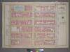
Plate 41, Part of Section 4: [Bounded by W. 59th Street, Ninth Avenue, W. 53rd Street and Eleventh Avenue.]
from Atlas of the city of New York, borough of Manhattan. From actual surveys and official plans / by George W. and Walter S. Bromley.
Part of Section 4 : Plate 82.
from Atlas of the borough of Manhattan, city of New York.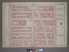
Plate 42, Part of Section 4: [Bounded by W. 59th Street, Central Park South, Seventh Avenue, W. 53rd Street and Ninth Avenue.]
from Atlas of the city of New York, borough of Manhattan. From actual surveys and official plans / by George W. and Walter S. Bromley.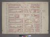
Plate 42, Part of Section 4: [Bounded by W. 59th Street, Central Park South, Seventh Avenue, W. 53rd Street and Ninth Avenue.]
from Atlas of the city of New York, borough of Manhattan. From actual surveys and official plans / by George W. and Walter S. Bromley.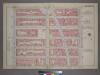
Plate 42, Part of Section 4: [Bounded by W. 59th Street - Central Park South, Seventh Avenue, W. 53rd Street and Ninth Avenue.]
from Atlas of the city of New York, borough of Manhattan. From actual surveys and official plans / by George W. and Walter S. Bromley.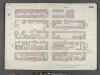
Manhattan, V. 6, Double Page Plate No. 104 [Map bounded by W. 57th St., 8th Ave., W. 52nd St., 10th Ave.]
From Atlas 117. Vol. 6, 1892.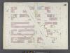
Manhattan, V. 6, Double Page Plate No. 116 [Map bounded by W. 67th St., Central Park West, W. 62nd St., Amsterdam Ave.]
From Atlas 117. Vol. 6, 1892.
Plate 104: Map bounded by West 57th Street, Eighth Avenue, West 52nd Street, Tenth Avenue
from Maps of the city of New York.
Plate 116: Map bounded by West 67th Street, Eighth Avenue, West 62nd Street, Tenth Avenue
from Maps of the city of New York.
Plate 114: Map bounded by West 64th Street, Tenth Avenue, West 57th Street, Hudson River
from Maps of the city of New York.
M-T-10-127: [Bounded by Columbus Circle, West 61st Street, West 62nd Street, West Drive andWst 59th Street.]
from Topographical survey of portion of Central Park, Boro. of Manhattan ... / City of New York, Department of Parks, Topographical Division.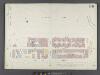
Manhattan, V. 6, Double Page Plate No. 111 1/2 [Map bounded by Central Park, 6th Ave., W. 57th St., 8th Ave., Central Park West]
From Atlas 117. Vol. 6, 1892.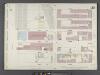
Manhattan, V. 6, Double Page Plate No. 113 [Map bounded by W. 62nd St., 10th Ave., W. 57th St., 12th Ave.]
From Atlas 117. Vol. 6, 1892.
Plate 112: Map bounded by West 59th Street, Sixth Avenue, West 57th Street, Eighth Avenue
from Maps of the city of New York.
M-T-10-125: [Bounded by West 63rd Street, West 64th Street, West 65th Street, West Drive and Bridle Path.]
from Topographical survey of portion of Central Park, Boro. of Manhattan ... / City of New York, Department of Parks, Topographical Division.
Part of Section 3 : New York City.
from Atlas of the city of New York, Manhattan Island. From actual surveys and official plans / by George W. and Walter S. Bromley.
[Plate 23: Bounded by Ninth Avenue, Columbus Avenue, W. 64th Street, Central Park West, Columbus Circle, Central Park South, Sixth Avenue, and W. 47th Street.]
from Atlas of the city of New York, borough of Manhattan. From actual surveys and official plans / by George W. and Walter S. Bromley.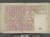
Manhattan, Double Page Plate No. 23 [Map bounded by 9th Ave., W. 59th St., 6th Ave., W. 47th St.]
From Atlas of the city of New York, Manhattan Island. From actual surveys and official plans
Part of Ward 22, New York City.
from Atlas of the city of New York : embracing all territory within its corporate limits from official records, private plans & actual surveys / by and under the supervision of E. Robinson & R.H. Pidgeon, civil engineers.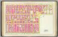
![Manhattan, V. 6, Double Page Plate No. 112 [Map bounded by W. 62nd St., Central Park West, 8th Ave., W. 57th St., 10th Ave.]](https://images-2.georeferencer.com/images/iiif/556864790209/full/,300/0/native.jpg)

