Maps of Queens County
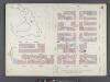
Manhattan, V. 6, Double Page Plate No. 111 [Map bounded by E. 62nd St., Park Ave., E. 57th St., W. 57th St., 6th Ave.]
From Atlas 117. Vol. 6, 1892.
Plate 111: Map bounded by East 62nd Street, Fourth Avenue, East 57th Street, West 57th Street, Sixth Avenue, West 59th Street
from Maps of the city of New York.
M-T-10-128: [Bounded by (The Pond) East Drive, East 62nd Street, East 61st Street and East 60th Street.]
from Topographical survey of portion of Central Park, Boro. of Manhattan ... / City of New York, Department of Parks, Topographical Division.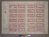
Plate 19, Part of Section 5: [Bounded by E. 65th Street, Third Avenue, E. 59th Street and (Central Park) Fifth Avenue.]
from Atlas of the city of New York, borough of Manhattan. From actual surveys and official plans / by George W. and Walter S. Bromley.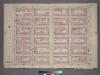
Plate 19, Part of Section 5: [Bounded by E. 65th Street, Third Avenue, E. 59th Street and Fifth Avenue.]
from Atlas of the city of New York, borough of Manhattan. From actual surveys and official plans / by George W. and Walter S. Bromley.
[Plate 104: Bounded by E. 65th Street, Third Avenue, E. 59th Street, and (Central Park) Fifth Avenue.]
from Atlas of the borough of Manhattan, city of New York.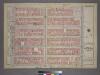
Plate 43, Part of Sections 4&5: [Bounded by Central Park South, Fifth Avenue, W. 53rd Street and Seventh Avenue.]
from Atlas of the city of New York, borough of Manhattan. From actual surveys and official plans / by George W. and Walter S. Bromley.
[Plate 84: Bounded by E. 59th Street, Third Avenue, E. 53rd Street, and Fifth Avenue.]
from Atlas of the borough of Manhattan, city of New York.
[Plate 83: Bounded by Central Park South, Fifth Avenue, W. 53rd Street, and Seventh Avenue.]
from Atlas of the borough of Manhattan, city of New York.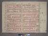
Plate 43, Part of Sections 4&5: [Bounded by Central Park South, Fifth Avenue, W. 53rd Street and Seventh Avenue.]
from Atlas of the city of New York, borough of Manhattan. From actual surveys and official plans / by George W. and Walter S. Bromley.
Pl. 22: ward 19.
1 : 1800 Bromley, George Washington; Bromley, Walter Scott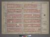
Plate 43, Part of Sections 4&5: [Bounded by Central Park South, Fifth Avenue, W. 53rd Street and Seventh Avenue.]
from Atlas of the city of New York, borough of Manhattan. From actual surveys and official plans / by George W. and Walter S. Bromley.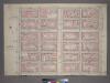
Plate 44, Part of Section 5: [Bounded by E. 59th Street, Third Avenue, E. 53rd Street and Fifth Avenue.]
from Atlas of the city of New York, borough of Manhattan. From actual surveys and official plans / by George W. and Walter S. Bromley.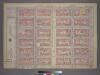
Plate 44, Part of Section 5: [Bounded by E. 59th Street, Third Avenue, E. 53rd Street and Fifth Avenue.]
from Atlas of the city of New York, borough of Manhattan. From actual surveys and official plans / by George W. and Walter S. Bromley.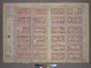
Plate 44, Part of Section 5: [Bounded by E. 59th Street, Third Avenue, E. 53rd Street and Fifth Avenue.]
from Atlas of the city of New York, borough of Manhattan. From actual surveys and official plans / by George W. and Walter S. Bromley.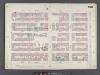
Manhattan, V. 6, Double Page Plate No. 106 [Map bounded by W. 57th St., E. 57th St., Park Ave., E. 52nd St., W. 52nd St., 6th Ave.]
From Atlas 117. Vol. 6, 1892.
Plate 106: Map bounded by West 57th Street, East 57th Street, Fourth Avenue, East 57th Street, West 57th Street, Sixth Avenue
from Maps of the city of New York.
M-T-10-126: [Bounded by (The Pond) East Drive, East 65th Street, East 64th Street, East 63rd.]
from Topographical survey of portion of Central Park, Boro. of Manhattan ... / City of New York, Department of Parks, Topographical Division.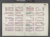
Manhattan, V. 6, Double Page Plate No. 118 [Map bounded by W. 67th St., 5th Ave., E. 62nd St., 3rd Ave.]
From Atlas 117. Vol. 6, 1892.
Plate 118: Map bounded by East 67th Street, Third Avenue, East 62nd Street, Fifth Avenue
from Maps of the city of New York.
Plate 110: Map bounded by East 62nd Street, Second Avenue, East 57th Street, Fourth Avenue
from Maps of the city of New York.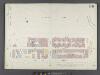
Manhattan, V. 6, Double Page Plate No. 111 1/2 [Map bounded by Central Park, 6th Ave., W. 57th St., 8th Ave., Central Park West]
From Atlas 117. Vol. 6, 1892.
Plate 112: Map bounded by West 59th Street, Sixth Avenue, West 57th Street, Eighth Avenue
from Maps of the city of New York.
M-T-10-127: [Bounded by Columbus Circle, West 61st Street, West 62nd Street, West Drive andWst 59th Street.]
from Topographical survey of portion of Central Park, Boro. of Manhattan ... / City of New York, Department of Parks, Topographical Division.
Part of Section 5 : New York City.
from Atlas of the city of New York, Manhattan Island. From actual surveys and official plans / by George W. and Walter S. Bromley.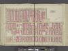
Manhattan, Double Page Plate No. 22 [Map bounded by 6th Ave., E. 64th St., Lexington Ave., E. 47th St.]
From Atlas of the city of New York, Manhattan Island. From actual surveys and official plans
[Plate 18: Bounded by E. 64th Street, Avenue A, E. 52nd Street, W. 52nd Street, Sixth Avenue, W. 59th Street and Fifth Avenue.]
from Atlas of the city of New York : embracing all territory within its corporate limits from official records, private plans & actual surveys / by and under the supervision of E. Robinson & R.H. Pidgeon, civil engineers.
Sackersdorff Farm Set.
from Maps of farms commonly called the Blue book, 1815 : drawn from the original on file in the street commissioner's office in the City of New York, together with lines of streets and avenues / laid out by John Randel, jr., 1819-20.
[Plate 22: Bounded by Sixth Avenue, Central Park South, Fifth Avenue, E. 64th Street, Lexington Avenue, and E. 47th Street.]
from Atlas of the city of New York, borough of Manhattan. From actual surveys and official plans / by George W. and Walter S. Bromley.
![Manhattan, V. 6, Double Page Plate No. 111 [Map bounded by E. 62nd St., Park Ave., E. 57th St., W. 57th St., 6th Ave.]](https://images-2.georeferencer.com/images/iiif/673871704655/full/,300/0/native.jpg)

