Maps of Hudson County

Manhattan, V. 1, Plate No. West piers A [Map of west piers A.]
From Atlas 107. Vol. 1, 1894.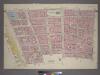
Plate 3, Part of Section 1: [Bounded by Vesey Street, Ann Street, William Street, Pine Street, Broadway, Thames Street, Greenwich Street, Carlisle Street and (Hudson River Piers) West Street.]
from Atlas of the city of New York, borough of Manhattan. From actual surveys and official plans / by George W. and Walter S. Bromley.
[Map bounded by Pier - Line 1-15, Liberty St, Washington Street, Battery Place; Including West Street, Morris St, Rector St, Carlisle St, Albany St, Cedar St]
from Maps of the wharves & piers from the Battery to 61st street on the Hudson river and from the Battery to 41st street on the East river, New York. Surveyed by I.C. Buckhout, city surveyor.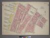
Plate 2, Part of Section 1: [Bounded by Carlisle Street, Greenwich Street, Thames Street, Broadway, Pine Street, William Street, Exchange Place, Broad Street, Beaver Street, Bowling Green, Battery Place, and (Hudson River Piers) West Street.]
from Atlas of the city of New York, borough of Manhattan. From actual surveys and official plans / by George W. and Walter S. Bromley.
[1st Ward. Plate D: Map bounded by West Street, Rector Street, Broadway, Battery Place; Including Washington Street, Greenwich Street, Trinity Place, Morris Street, Edgar Street, Exchange Place]
from Maps of the city of New York.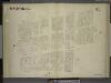
[1st & 3rd Wards. Plate E: Map bounded by West Street, Courtland Street, Greenwich Street, Liberty Street, Trinity Place, Rector Street; Including Washington Street Carlisle Street, Albany Street, Cedar Street]
from Maps of the city of New York.
Manhattan, V. 1, Plate No. 3 west half [Map bounded by Dey St., Trinity Pl., Church St., Rector St., West St.]
From Atlas 107. Vol. 1, 1894.
Map of the proposed widening of Rector & Morris streets / New York, May 1849, Joseph F. Bridges, city surveyor.
from Manhattan
Plate 3: Map bounded by Liberty Street, Nassau Street, Broad Street, Exchange Place, Broadway, Rector Street, West Street
from Maps of the city of New York / surveyed under directions of insurance companies of said city.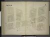
[3rd Ward. Plate 3: Map bounded by West Street, Robinson Street, College Place, Barclay Street, Greenwich Street, Courtland Street; Including Washington Street, Dey Street, Fulton Street, Vesey Street]
from Maps of the city of New York.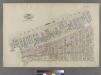
Part of Wards 1 & 3, New York City.
from Atlas of the city of New York : embracing all territory within its corporate limits from official records, private plans & actual surveys / by and under the supervision of E. Robinson & R.H. Pidgeon, civil engineers.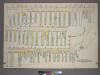
Plate 39, Sec. 2 & Sec. 1: Plan of Hudson River Wharves. [Covers the Wharves between Perry Street - Battery Park on West Street.]
from Atlas of the city of New York, borough of Manhattan. From actual surveys and official plans / by George W. and Walter S. Bromley.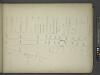
[Map bounded by Pier - Line 1-24, Vesey Street, Broadway, Battery Place; Including West Street, Washington Street, Greenwich Street, Morris Street, Rector Street, Carlisle Street, Albany Street, Cedar Street, Liberty Street, Jersey City
from Maps of the wharves and piers on the Hudson and East rivers from the Battery to 13th St., New York.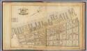
1. Ward 1,3.
1 : 2400 G.W. Bromley & Co.; Geo. W. Bromley & E. Robinson
[Plate 1: Bounded by Liberty Street, Maiden Lane, South Street [East River, Piers 1-18], White Hall Street, State Street (Battery Park), Battery Place,and (Hudson River, Piers A, 1-14) West Street.]
from Atlas of the city of New York, Manhattan Island. From actual surveys and official plans / by George W. and Walter S. Bromley.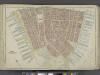
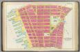
Manhattan, Double Page Plate No. 1 [Map bounded by Liberty St., Maiden Lane, East River, Hudson River]
From Atlas of the city of New York, Manhattan Island. From actual surveys and official plans
Part of Section 1 : New York City.
from Atlas of the city of New York, borough of Manhattan. From actual surveys and official plans / by George W. and Walter S. Bromley.
Part of Section 1 : New York City.
from Atlas of the city of New York, Manhattan Island. From actual surveys and official plans / by George W. and Walter S. Bromley.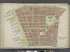
Manhattan, Double Page Plate No. 2 [Map bounded by Jay St., Thomas St., Pearl St., William St., Liberty St., Hudson River]
From Atlas of the city of New York, Manhattan Island. From actual surveys and official plans
[Map bounded by Pier - Line 15-29, Warren St, Washington St, Liberty St; Including West Street, Courtlandt St, Dey St, Fulton St, Vesey St, Barclay St, Robinson St, Murray St]
from Maps of the wharves & piers from the Battery to 61st street on the Hudson river and from the Battery to 41st street on the East river, New York. Surveyed by I.C. Buckhout, city surveyor.
Part of Section 1 : Plate 3.
from Atlas of the borough of Manhattan, city of New York.
Nieuw Amsterdam: the Dutch settlement in the New World that became New York, following the plan sent October 6, 1660 by Governor Peter Stuyvesant to the West India Company in Holland, with additions concerning persons, places and events until the year 1699.
Pl. 2: wards 2-6.
1 : 1800 Bromley, George Washington; Bromley, Walter Scott
Part of Section 1 : Plate 2.
from Atlas of the borough of Manhattan, city of New York.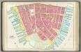
Pl. 1: ward 1.
1 : 1800 Bromley, George Washington; Bromley, Walter Scott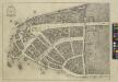
Redraft of the Castello Plan, New Amsterdam in 1660.
from Iconography of Manhattan Island, 1498-1909 / by I. N. Phelps Stokes.
[Plate 2: Map bounded by Rector Street, Wall Street, Broad Street, Exchange Place, William Street, Beaver Street, Marketfield Street, Bowling Green, Battery Place, West Street; Including Edgar Street, Oyster Pastie Lane, Morris Street, Washington Str
from Maps of the city of New-York.
[Plate 3: Map bounded by Dey Street, Broadway, Maiden Lane, Nassau Street, Wall Street, Broadway, Rector Street, West Street]
from Maps of the city of New York.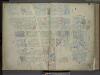
[Plate 3: Map bounded by Dey Street, Broadway, Maiden Lane, Nassau Street, Wall Street, Rector Street, West Street; Including Courtlandt Street, Liberty Street, Cedar Street, Albany Street, Thames Street, Pine Street, Carlisie Street, Washi
from Maps of the city of New-York.
![Manhattan, V. 1, Plate No. West piers A [Map of west piers A.]](https://images-2.georeferencer.com/images/iiif/284087349816/full/,300/0/native.jpg)

