Maps of Hudson County

Manhattan, V. 1, Plate No. 21 south half [Map bounded by Thompson St., Grand St., Broadway, Canal St.]
From Atlas 107. Vol. 1, 1894.
Manhattan, V. 1, Plate No. 16 [Map bounded by Hudson St., Laight St., Canal St., Church St., White St., North Moore St.]
From Atlas 107. Vol. 1, 1894.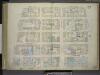
[Plate 22: Map bounded by Thompson Street, Spring Street, Broadway, Canal Street; Including Laurens Street, Wooster Street, Greene Street, Mercer Street, Grand Street, Broome Street]
from Maps of the city of New-York.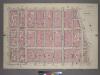
Plate 20, Part of Section 2: [Bounded by Prince Street, Marion Street, Centre Street, Grand Street and Sullivan Street.]
from Atlas of the city of New York, borough of Manhattan. From actual surveys and official plans / by George W. and Walter S. Bromley.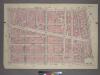
Plate 11, Part of Section 1: [Bounded by Grand Street, Mulberry Street, Baxter Street, Franklin Street and West Broadway.]
from Atlas of the city of New York, borough of Manhattan. From actual surveys and official plans / by George W. and Walter S. Bromley.
Part of Section 1 : Plate 11.
from Atlas of the borough of Manhattan, city of New York.
Plate 22: Map bounded by Spring Street, Broadway, Canal Street, Thompson Street
from Maps of the city of New York.
Plate 31: Map bounded by Spring Street, Mercer Street, Canal Street, Laurens Street.
from Maps of the city of New York / surveyed under directions of insurance companies of said city.
Plate 29: Map bounded by Canal Street, Centre Street, Leonard Street, West Broadway.
from Maps of the city of New York / surveyed under directions of insurance companies of said city.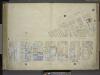
[Plate 16: Map bounded by West Broadway, Varick Street, Laight Street, Canal Street, Church Street, Thomas Street; Including St.John Park, Worth Street, Leonard Street, Franklin Street, White Street, North Moore Street, Walker Street, Beach
from Maps of the city of New-York.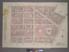
Plate 10, Part of Sections 1&2: [Bounded by Watts Street, Sullivan Street, Grand Street, West Broadway, N. Moore Street and West Street.]
from Atlas of the city of New York, borough of Manhattan. From actual surveys and official plans / by George W. and Walter S. Bromley.
Plate 35: Map bounded by Spring Street, Laurens Street, Canal Street, West Broadway, Beach Street, St. John's Lane, Laight Street, Canal Street, Varick Street.
from Maps of the city of New York / surveyed under directions of insurance companies of said city.
Plate 30: Map bounded by Spring Street, Elm Street, Broome Street, Centre Street, Canal Street, Mercer Street.
from Maps of the city of New York / surveyed under directions of insurance companies of said city.
Manhattan, V. 1, Plate No. 15 [Map bounded by Church St., Canal St., Elm St., Franklin St.]
From Atlas 107. Vol. 1, 1894.
[Plate 16: Map bounded by Laight Street, Canal Street, Church Street, Thomas Street, West Broadway, Franklin Street, Varick Street]
from Maps of the city of New York.
Manhattan, V. 1, Plate No. 70 [Map bounded by Spring St., Broadway, Grand St., Wooster St.]
From Atlas 108. Vol. 1, [1903?].
[Plate 15: Map bounded by Canal Street, Elm Street, Pearl street, Church Street]
from Maps of the city of New York.
Manhattan, V. 1, Plate No. 21 [Map bounded by Thompson St., Spring St., Broadway, Grand St.]
From Atlas 107. Vol. 1, 1894.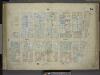
[Plate 15: Map bounded by Church Street, Canal Street, Elm Street, Pearl Street; Including Franklyn Place, Broadway, Benson Street, Courtlandt Alley, Worth Street, Leonard Street, Franklin Street, White Street, Walker Street, Lispenard St
from Maps of the city of New-York.
Manhattan, V. 1, Plate No. 23 west half [Map bounded by Broome St., Baxter St., Canal St., Broadway]
From Atlas 107. Vol. 1, 1894.
Part of Section 2 : Plate 20.
from Atlas of the borough of Manhattan, city of New York.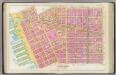
Pl. 4: wards 5-6, 8, 14.
1 : 1800 Bromley, George Washington; Bromley, Walter Scott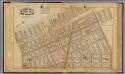
3. Wards 5, 8.
1 : 2400 G.W. Bromley & Co.; Geo. W. Bromley & E. Robinson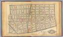
4. Wards 5-6, 8, 14.
1 : 2400 G.W. Bromley & Co.; Geo. W. Bromley & E. Robinson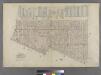
Part of Wards 5 & 8, New York City.
from Atlas of the city of New York : embracing all territory within its corporate limits from official records, private plans & actual surveys / by and under the supervision of E. Robinson & R.H. Pidgeon, civil engineers.
Part of Sections 1 & 2 : New York City.
from Atlas of the city of New York, Manhattan Island. From actual surveys and official plans / by George W. and Walter S. Bromley.
[Plate 4: Bounded by Spring Street, Hudson Street, Broome Street, Centre Street, Pearl Street, Thomas Street, Hudson Street, Jay Sreet and [Hudson River, Piers 22-34] West Street.]
from Atlas of the city of New York, borough of Manhattan. From actual surveys and official plans / by George W. and Walter S. Bromley.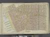
Manhattan, Double Page Plate No. 4 [Map bounded by Spring St., Broome St., Centre St., Pearl St., Thomas St., Jay St., Hudson River]
From Atlas of the city of New York, Manhattan Island. From actual surveys and official plans
A view of Collect Pond and its vicinity in the City of New York in 1793 : on which pond the first boat propelled by paddle wheels and screw-propellers constructed by John Fitch, six years before Robert Fulton ... / by John Hutchings ; drawn & lith. b
from Manhattan
![Manhattan, V. 1, Plate No. 21 south half [Map bounded by Thompson St., Grand St., Broadway, Canal St.]](https://images-2.georeferencer.com/images/iiif/816059692032/full/,300/0/native.jpg)

