Maps of Richmond County

Staten Island, V. 1, Plate No. 22 [Map bounded by Broad, Brownell, Harrison, Quinn, Upper New York Bay, Thompson]
From Atlas 162. Vol. 1, 1917.
Staten Island, Plate No. 11 [Map bounded by Brooks, Vanderbilt, New York Bay, Thompson]
From Atlas 159, 1885.
Staten Island, Plate No. 15 [Map bounded by Brooks, Thompson, Harrison]
From Atlas 159, 1885.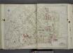
Part of Ward 2. [Map bound by St. Pauls Ave, Beach St, Jackson St, Van Duzer St (Richmond RD), Sands St, Wave St, Front St, Thompson St, Bay St, Broad St, Gordon St, Purroy St (Elm), Targee St]
from Atlas of the city of New York, borough of Richmond, Staten Island. From actual surveys and original plans, by George W. and Walter S. Bromley.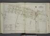
Part of Ward 2. [Map bound by Broad St, Bay St, Thompson St, Front St, Dock St, Vanderbilt Ave, Pleasant PL, Coursen PL, Dix PL (Elm), Hill St, Fulton St, Meadow St, Patten St]
from Atlas of the city of New York, borough of Richmond, Staten Island. From actual surveys and original plans, by George W. and Walter S. Bromley.
Borough of Richmond, Topographical Survey.
from Borough of Richmond, Topographical Survey.
Staten Island, V. 1, Plate No. 32 [Map bounded by Harrison, Brownel, Upper New York Bay, Simonson Ave., Tompkins Ave.]
From Atlas 162. Vol. 1, 1917.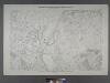
Sheet No. 33. [Includes Concord, Grasmere, Fort Wadsworth and Rose Bank.]; Borough of Richmond, Topographical Survey.
from Borough of Richmond, Topographical Survey. Staten Island. Topographical Bureau.,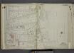
Part of Ward 4. [Map bound by Vanderbilt Ave, Pierhead Line, North St, Front St, Maple Ave, Edgewater St (Bay St), Bay St (New York Ave), Chestnut Ave, Tompkins Ave (Centre St)]
from Atlas of the city of New York, borough of Richmond, Staten Island. From actual surveys and original plans, by George W. and Walter S. Bromley.
Staten Island, Plate No. 12 [Map bounded by Boyd, Brooks, Mc Keon, Varian Cedar]
From Atlas 159, 1885.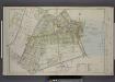
Part of Ward 2. [Map bound by Eddy St, Howard Ave, Trossach Road, St. Pauls Ave, Richmond Road, Beach St, Union PL, Cross St, Bulkhead Line, Vanderbilt Ave, Irving PL, Woodside Ave]
from Atlas of the borough of Richmond, city of New York.
Section 9
from Atlas of Staten Island, Richmond County, New York, from official records and surveys; compiled and drawn by F. W. Beers.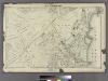
Section 8.
from Atlas of Staten Island, Richmond County, New York, from official records and surveys; compiled and drawn by F. W. Beers.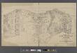
Map of New Brighton, Staten Island [cartographic material] : 1st, 2nd and 3rd wards.
From Staten Island
21B - N.Y. City (Aerial Set).
from Sectional aerial maps of the City of New York / [photographed and assembled under the direction of the chief engineer, July 1st, 1924].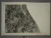
21D - N.Y. City (Aerial Set).
from Sectional aerial maps of the City of New York / [photographed and assembled under the direction of the chief engineer, July 1st, 1924].
Map of Staten Island, Richmond County, New York City, from surveys under the direction of H. F. Walling.
From Staten Island
Height District Map Section No. 21; Height district map / City of New York, Board of Estimate and Apportionment.
from Height district map / City of New York, Board of Estimate and Apportionment. New York (N.Y.). Board of Estimate and Apportionment,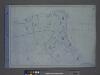
Area District Map Section No. 21; Area district map / City of New York, Board of Estimate and Apportionment.
from Area district map / City of New York, Board of Estimate and Apportionment. New York (N.Y.). Board of Estimate and Apportionment,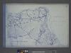
Use District Map Section No. 21; Use district map / City of New York, Board of Estimate and Apportionment.
from Use district map / City of New York, Board of Estimate and Apportionment. New York (N.Y.). Board of Estimate and Apportionment,
Jersey City, V. 1, Double Page Plate No. 24 [Map bounded by Ocean Ave., Linden Ave., Morris Canal, Avenue C] / compiled under the direction of and published by G.M. Hopkins Co.
From V. 1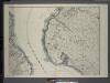
General map of the borough of Richmond (Staten Island) in the city of New York : showing in addition to the existing topographical features of the borough a tentative and preliminary plan for a street system of the same.
from Staten Island
General map of the borough of Richmond (Staten Island) in the city of New York : showing in addition to the existing topographical features of the borough a tentative and preliminary plan for a street system of the same.
from Staten Island
Brighton Heights, Clifton, Fort Wadsworth, Fox Hills, Grymes hill, Livingston, New Brighton, Randall Manor, Rosebank, Shore Acres, St. George, Stapleton, Tompkinsville, Ward hill, West New Brighton. (cont.)
From District 2
Map of the Marine Hospital ground, Staten Island / reduced from a survey, made by John Ewen, dated March 1845 by Daniel Ewen, city surveyor.
from Staten Island
Map of the Village of New Brighton, Richmond Co., New York City, NY.
From Staten Island
Map of the City of Brooklyn as consolidated by an act of the Legislature of the Ste of New York . . . Constructed from the official maps of the Commissioners . . . Exhibiting the farm lines names of the original owners.
From Brooklyn
Bath, Town on New Utrecht, Kings Co.
from Atlas of Long Island, New York. From recent and actual surveys and records.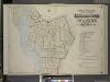
Index to Volume One, Atlas of the Borough of Brooklyn Sections 1, 2, 3 & 4. Wards 1, 2, 3, 4, 5, 6, 8, 9, 10, 12 & 22. City of New York. Published by E. Belcher Hyde, 97 Liberty St., Brooklyn. 1903.
from Wards 1, 2, 3, 4, 5, 6, 8, 9, 10, 12 & 22.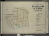
![Staten Island, V. 1, Plate No. 22 [Map bounded by Broad, Brownell, Harrison, Quinn, Upper New York Bay, Thompson]](https://images-2.georeferencer.com/images/iiif/203777924852/full/,300/0/native.jpg)

