Maps of Bayonne

Staten Island, V. 1, Plate No. 1 [Map bounded by Kill van Kull, Westervelt Ave., York Ave.]
From Atlas 162. Vol. 1, 1917.
Staten Island, Plate No. 2 [Map bounded by Bank, westervelt Ave., York Ave.]
From Atlas 159, 1885.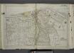
Part of Ward 1. [Map bound by Pierhead Line, Richmond Terrace, Nicholas St, St. Marks PL, Hamilton Ave, Daniel Low Terrace, Fort PL, Taft Ave (6th Ave), Jersey St, Pauw St (Center), York Ave, Prospect Ave, La Fayette Ave]
from Atlas of the city of New York, borough of Richmond, Staten Island. From actual surveys and original plans, by George W. and Walter S. Bromley.
Borough of Richmond, Topographical Survey.
from Borough of Richmond, Topographical Survey.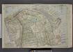
Part of Ward 1. [Map bound by Kill Van Kull, Pier Head of 1889 & 1904, Arrietta St, First Ave, Westervelt Ave, Second Ave, York Ave, Eleventh St, Prospect Ave, Franklin Ave]
from Atlas of the borough of Richmond, city of New York.
Richmond, Plate No. 48 [Map bounded by St. Marks Pl., Richmond Terrace East, Jay St., Fort St., Westervelt Ave.]
From Atlas 160, 1898.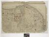
Part of New Brighton : Town of Castleton.
From Atlas of Staten Island, Richmond County, New York, from official records and surveys; compiled and drawn by F. W. Beers.
Part of New Brighton : Town of Castleton.
from Atlas of Staten Island, Richmond County, New York, from official records and surveys; compiled and drawn by F. W. Beers.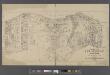
Map of New Brighton, Staten Island [cartographic material] : 1st, 2nd and 3rd wards.
From Staten Island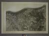
21A - N.Y. City (Aerial Set).
from Sectional aerial maps of the City of New York / [photographed and assembled under the direction of the chief engineer, July 1st, 1924].
21B - N.Y. City (Aerial Set).
from Sectional aerial maps of the City of New York / [photographed and assembled under the direction of the chief engineer, July 1st, 1924].
Map of Staten Island, Richmond County, New York City, from surveys under the direction of H. F. Walling.
From Staten Island
Height District Map Section No. 21; Height district map / City of New York, Board of Estimate and Apportionment.
from Height district map / City of New York, Board of Estimate and Apportionment. New York (N.Y.). Board of Estimate and Apportionment,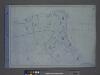
Area District Map Section No. 21; Area district map / City of New York, Board of Estimate and Apportionment.
from Area district map / City of New York, Board of Estimate and Apportionment. New York (N.Y.). Board of Estimate and Apportionment,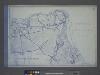
Use District Map Section No. 21; Use district map / City of New York, Board of Estimate and Apportionment.
from Use district map / City of New York, Board of Estimate and Apportionment. New York (N.Y.). Board of Estimate and Apportionment,
Jersey City, V. 1, Double Page Plate No. 24 [Map bounded by Ocean Ave., Linden Ave., Morris Canal, Avenue C] / compiled under the direction of and published by G.M. Hopkins Co.
From V. 1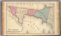
Bayonne; Greenville Twp.
1 : 19200 Beers, F. W. (Frederick W.)
General map of the borough of Richmond (Staten Island) in the city of New York : showing in addition to the existing topographical features of the borough a tentative and preliminary plan for a street system of the same.
from Staten Island
Brighton Heights, Clifton, Fort Wadsworth, Fox Hills, Grymes hill, Livingston, New Brighton, Randall Manor, Rosebank, Shore Acres, St. George, Stapleton, Tompkinsville, Ward hill, West New Brighton. (cont.)
From District 2
Map of the Marine Hospital ground, Staten Island / reduced from a survey, made by John Ewen, dated March 1845 by Daniel Ewen, city surveyor.
from Staten Island
Map of the Village of New Brighton, Richmond Co., New York City, NY.
From Staten Island
Jersey City
1 : 24000
Jersey City
1 : 24000
Jersey City
1 : 24000
Jersey City
1 : 24000
Jersey City
1 : 24000
Map of the City of Brooklyn as consolidated by an act of the Legislature of the Ste of New York . . . Constructed from the official maps of the Commissioners . . . Exhibiting the farm lines names of the original owners.
From Brooklyn
Map of Staten Island, Richmond County, New York City, from surveys under the direction of H. F. Walling.
From Staten Island
Taunton's pocket edition of the merchant's and shipper's guide map to the port of New York / S.D.L. Taunton.
from Whole
![Staten Island, V. 1, Plate No. 1 [Map bounded by Kill van Kull, Westervelt Ave., York Ave.]](https://images-2.georeferencer.com/images/iiif/879288296521/full/,300/0/native.jpg)

