Maps of Kings County

Queens V. 8, Plate No. 96 [Map bounded by Beach 130th St., Atlantic Ocean, Beach 136th St., Rockaway Beach Blvd.]
From Atlas 145a. Vol. 8, 1912.
Queens V. 8, Plate No. 91 [Map bounded by Beach 129th St., Rockaway Beach Blvd., Beach 135th St., Newport Ave.]
From Atlas 145a. Vol. 8, 1912.
Queens V. 8, Plate No. 94 [Map bounded by Beach 135th St., Rockaway Beach Blvd., Beach 141st St., Newport Ave.]
From Atlas 145a. Vol. 8, 1912.
Queens V. 8, Plate No. 87 [Map bounded by Beach 125th St., Atlantic Ocean, Beach 130th St., Rockaway Beach Blvd.]
From Atlas 145a. Vol. 8, 1912.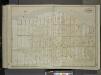
Queens, Vol. 1, Double Page Plate No. 39; Part of Ward 5; Farrockaway; [Map bounded by Park Ave., Southampton Ave., Ostend Ave., Dover Ave., Brighton Ave., Essex Ave., Norfolk Ave., Oxford Ave., Henley Ave., Suffolk Ave., Dennison Ave., Montau
from Fourth and fifth wards: Jamaica and Rockaway.
Queens V. 8, Plate No. 95 [Map bounded by Beach 136th St., Atlantic Ocean, Adirondack Blvd., Rockaway Beach Blvd.]
From Atlas 145a. Vol. 8, 1912.
Queens V. 8, Plate No. 92 [Map bounded by Beach 123rd St., Rockaway Beach Blvd., Beach 129th St., Newport Ave.]
From Atlas 145a. Vol. 8, 1912.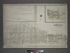
Part of the Borough of Queens, Far Rockaway, Ward 5.
from Atlas of the city of New York, borough of Queens, Long Island City, Newtown, Flushing, Jamaica, Far Rockaway, from actual surveys and official plans / by George W. and Walter S. Bromley.
30C - N.Y. City (Aerial Set).
from Sectional aerial maps of the City of New York / [photographed and assembled under the direction of the chief engineer, July 1st, 1924].
Use District Map Section No. 30; Use district map / City of New York, Board of Estimate and Apportionment.
from Use district map / City of New York, Board of Estimate and Apportionment. New York (N.Y.). Board of Estimate and Apportionment,
Area District Map Section No. 30
from Area district map / City of New York, Board of Estimate and Apportionment.
Height District Map Section No. 30
from Height district map / City of New York, Board of Estimate and Apportionment.
Queens, Vol. 1, Double Page Plate No. 40; Part of Ward 5; Farrockaway; [map bounded by Jamaica Bay, Atlantic Ocean; Including Washington Ave.]
from Fourth and fifth wards: Jamaica and Rockaway.
Key
From Atlas 145a. Vol. 8, 1912.
Far Rockaway
1 : 24000
Far Rockaway
1 : 24000
Far Rockaway
1 : 24000
Far Rockaway
1 : 24000
Index Map to Volume Two. Atlas of the Brooklyn Borough of the City of New York.
from Atlas of the Brooklyn borough of the City of New York : originally Kings Co.; complete in three volumes ... based upon official maps and plans ... / by and under the supervision of Hugo Ullitz, C.E.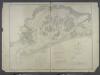
Jamaica Bay and Rockaway Inlet, Long Island, New York.
from U.S. Coast and Geodetic Survey. Nautical chart ; no. 542.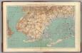
Narrows-Jamaica Bay, Brooklyn.
1 : 31680 Vermeule, C. C. (Cornelius Clarkson), 1858-1950
Guide map of Brooklyn, Kings County, N.Y. ....for Brooklyn daily eagle almanac.
From Brooklyn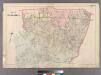
Plate 28: Town of Jamaica.
from Atlas of Queens Co., Long Island, New York / compiled from official records, private plans & actual surveys by and under the direction of Chester Wolverton.
Guide map of the borough of Brooklyn, Kings County, New York.
From Brooklyn
City of New York, Borough of Brooklyn ; map showing section stations, stables, and dumps.
From Brooklyn
Map of Brooklyn.
From Brooklyn
Map of New-York Bay and Harbor and the environs / founded upon a trigonometrical survey under the direction of F.R. Hassler, superintendent of the Survey of the Coast of the United States ; triangulation by James Ferguson and Edmund Blunt assistants ; th
from New York harbor
Brooklyn
1 : 62500
Brooklyn
1 : 62500
Brooklyn
1 : 62500
Brooklyn
1 : 62500
Brooklyn
1 : 62500
Brooklyn
1 : 62500
Brooklyn
1 : 62500
Brooklyn
1 : 62500
Brooklyn
1 : 62500
Brooklyn
1 : 62500
Brooklyn
1 : 62500
Brooklyn
1 : 62500
Brooklyn
1 : 62500
![Queens V. 8, Plate No. 96 [Map bounded by Beach 130th St., Atlantic Ocean, Beach 136th St., Rockaway Beach Blvd.]](https://images-2.georeferencer.com/images/iiif/932350526535/full/,300/0/native.jpg)

