Maps of Kings County

Key
From Atlas 137. Vol. 3, 1902.
Plate 30: Town of Newtown.
from Atlas of Queens Co., Long Island, New York / compiled from official records, private plans & actual surveys by and under the direction of Chester Wolverton.
Index Map to Volume Two / by and under the supervision of Hugo Ullitz.
From v. 2
Fire department of the city of Brooklyn.
From Brooklyn
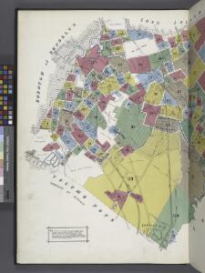
Queens, Vol.2, Double Page Plate No. 29; Part of Ward Two Newtown (East Williamsburgh, Melina and Nassau Heights); [Map bounded by Rotting Course Lane, Dry Harbor Road, Boundary between the Boroughs of Queens and Brooklyn, Newtown Creek, Bradle
from First and second wards: Long Island City and Newtown.
Area Zoning Map Section No. 13
From Area zoning map of the city of New York, compiled in the Dept. of City Planning, Division of Mapping and Zoning, May 27, 1953. Irving F. Ashworth, senior civil engineer.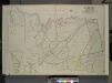
Queens, Vol. 2, Double Page Plate No. 28; Part of Ward Two Newtown, Corona, Hopedale and Richmond Hill; [Map bounded by Flushing Creek, Old Town of Jamaica and Newtown, Boundary Line between Jamaica and Newtown, Dry Harbor Road, Trotting
from First and second wards: Long Island City and Newtown.
Area District Map Section No. 13
from Area district map / City of New York, Board of Estimate and Apportionment.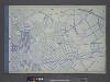
Use District Map Section No. 13
from Use district map / City of New York, Board of Estimate and Apportionment.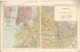
Hammods Atlas of New York City and the metropolitan district

Bushwick, Ridgewood. (cont.)
From District 4
Key Continued
From Atlas 148, Vol. 10, 1914.
Maspeth, Sunnyside, Woodside. (cont.)
From District 2
Key Continued
From Atlas 137a. Vol. 3, 1914.
Key
From Atlas 137a. Vol. 3, 1914.
Map of Newtown Creek and vicinity [and factories nearby.]
From Brooklyn
Map of the city of Brooklyn, as laid out by commissioners, and confirmed by acts of the Legislature of the state of New York : made from actual surveys, the farm lines and names of original owners, being accurately drawn from authentic sources, contai...
From Brooklyn
Community resources
From District 5
Area Zoning Map Section No. 17
From Area zoning map of the city of New York, compiled in the Dept. of City Planning, Division of Mapping and Zoning, May 27, 1953. Irving F. Ashworth, senior civil engineer.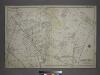
[Plate 18: Bounded by Remsen Street, North Hempstead Plank Road, Corona Avenue, Strongs Causeway, Douglass Street (Queensboro Hills), Ireland Hill Road, North Hempstead Turnpike, Renwick Avenue, Union Avenue, Metropolitan Avenue and Trotting Course.]
from Atlas of the city of New York, borough of Queens, Long Island City, Newtown, Flushing, Jamaica, Far Rockaway, from actual surveys and official plans / by George W. and Walter S. Bromley.
Spring Creek -- Linear City. (cont.)
From Spring Creek -- Linear City
Plate 40: Bounded by Corlears Street, Pierhead Line [Piers 45-1], Battery Park, Whitehall Street, and South Street.
from Atlas of the borough of Manhattan, city of New York.
Williamsburg, Greenpoint. (cont.)
From District 1
Queens, Vol. 2, Double Page Plate No. 30; Part of Ward Two Newtown, Trains Meadow, Wood Side and Elmhurst; [Map bounded by Bowery Bay, Flushing Bay, Corona, Junction Ave.; Including Elmhors Ave., Astoria and Flushing Turnpike, Woodside Ave., J
from First and second wards: Long Island City and Newtown.
Plan of the city of Brooklyn, L.I. / by William Perris.
from Brooklyn
Queens V. 3, Plate No. 119 [Map bounded by Hoffman Blvd., Hillside, Simpson St., Barnum Ave.]
From Atlas 137. Vol. 3, 1902.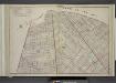
Brooklyn, Double Page Section 7; [Including Wards 18, 24, 25]
from Farm line map of the city of Brooklyn, from official records and surveys; comp. and drawn by Henry Fulton.
Height District Map Section No. 13; Height district map / City of New York, Board of Estimate and Apportionment.
from Height district map / City of New York, Board of Estimate and Apportionment. New York (N.Y.). Board of Estimate and Apportionment,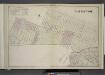
Brooklyn, Double Page Section 9; East New York; [Map bounded by Eldert Lane, Liberty Ave., Bennett Ave., New Lots Road, Duryea Ave., Centre Ave., Stmarks Ave., Saratoga Ave., Cooper PL., Mc. Dougal St.; Including Hopkinson Ave., Rockaway Ave., Gran
from Farm line map of the city of Brooklyn, from official records and surveys; comp. and drawn by Henry Fulton.
Area District Map Section No. 17; Area district map / City of New York, Board of Estimate and Apportionment.
from Area district map / City of New York, Board of Estimate and Apportionment. New York (N.Y.). Board of Estimate and Apportionment,
Use District Map Section No. 17; Use district map / City of New York, Board of Estimate and Apportionment.
from Use district map / City of New York, Board of Estimate and Apportionment. New York (N.Y.). Board of Estimate and Apportionment,