Maps of Queens County

Queens V. 2, Plate No. 33 [Map bounded by Grand Ave., 13th Ave., Jamaica Ave., 9th Ave.]
From Atlas 134. Vol. 2, 1915.
Queens V. 2, Plate No. 40 [Map bounded by 11th Ave., Grand Ave., 6th Ave., Vandeventer Ave.]
From Atlas 134. Vol. 2, 1915.
Queens V. 2, Plate No. 32 [Map bounded by Grand Ave., 9th Ave., Jamaica Ave., 5th Ave.]
From Atlas 134. Vol. 2, 1915.
Queens V. 2, Plate No. 25 [Map bounded by 14th Ave., Broadway, 9th Ave., Jamaica Ave.]
From Atlas 134. Vol. 2, 1915.
Queens V. 2, Plate No. 41 [Map bounded by 16th Ave., Grand Ave., 11th Ave., Vandeventer Ave.]
From Atlas 134. Vol. 2, 1915.
Queens V. 2, Plate No. 34 [Map bounded by Grand Ave., 17th Ave., Jamaica Ave., 13th Ave.]
From Atlas 134. Vol. 2, 1915.
Queens V. 2, Plate No. 23 [Map bounded by 9th Ave., Broadway, 4th Ave., Jamaica Ave.]
From Atlas 134. Vol. 2, 1915.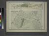
Part of Astoria. Long Island City, Queens Co. L.I.
from Atlas of Long Island, New York. From recent and actual surveys and records.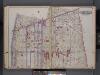
Queens, V. 2, Double Page Plate No. 9; Part of Long Island City, Ward 1; [Map bounded by Woolsey Ave., Potter Ave., Bowery Bay Rd., Patterson Ave., 2nd Ave.] / by and under the supervision of Hugo Ullitz.
From v. 2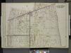
Queens, Vol. 2, Double Page No. 9; Part of Long Island City Ward One (Part of Old Wards 4 & 5); [Map bounded by Debevoise Ave., Woolsey Ave., Flushing Ave., Grand Ave., Vandeventer Ave., Rapelje Ave., 4th Ave., 5th Ave., 6th Ave., 7th Ave.,
from Long Island City.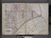
Queens, V. 2, Double Page Plate No. 6; Part of Long Island City, Ward 1; [Map bounded by Patterson Ave., Duane St., Woodside Ave., Middleburg Ave., Washington Ave., 4th Ave.] / by and under the supervision of Hugo Ullitz.
From v. 2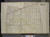
Queens, Vol. 2, Double Page Plate No. 9; Part of Long Island City Ward One (Part of Old Wards Four and Five); [Map bounded by Albert St., Theodore St., Sound St., Purdy St., Flushing Ave.; Including Old Bowery Bay Road, Jamaica Ave., Debevoise Ave.,
from First and second wards: Long Island City and Newtown.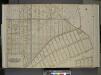
Queens, Vol. 2, Double Page Plate No. 6; Part of Long Island City Ward One (Part of Old Wards Two and Four); [Map bounded by Jamaica Ave., Old Bowery Bay Road, Woodside Ave., Middleburg Ave., Van Buren St., Lowery St.; Including Bragaw St., Harold S
from First and second wards: Long Island City and Newtown.
Queens, Vol. 2, Double Page Plate No. 6; Part of Long Island City Ward One (Part of Wards 2 and 4); [Map bounded by Jamaica Ave., North Wood Side, Middleburg Ave., Laurel Hill Ave., Madden St., Van Buren St., Lowery St., Bragaw St.; Including H
from First and second wards: Long Island City and Newtown.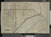
Queens, Vol. 2, Double Page No. 6; Part of Long Island City Ward One (Part of Old Ward 2 & 4) Sub Plan; [Map bounded by Harold Ave., Middleburg Ave.; Including Bragaw St., Lowery St., Van Buren St., Van Pelt St.]; Part of Long Island City Ward
from Long Island City.
Queens V. 2, Plate No. 43 [Map bounded by Wilson Ave., 14th Ave., Vandeventer Ave., Steinway Ave.]
From Atlas 134. Vol. 2, 1915.
Queens V. 2, Plate No. 27 [Map bounded by 19th Ave., Broadway, 14th Ave., Jamaica Ave.]
From Atlas 134. Vol. 2, 1915.
Queens V. 2, Plate No. 38 [Map bounded by 6th Ave., Grand Ave., Marc Pl., Vandeventer Ave.]
From Atlas 134. Vol. 2, 1915.
Queens V. 2, Plate No. 26 [Map bounded by 13th Ave., Graham Ave., 8th Ave., Broadway]
From Atlas 134. Vol. 2, 1915.
Queens V. 2, Plate No. 31 [Map bounded by Grand Ave., 5th Ave., Jamaica Ave., 1st Ave.]
From Atlas 134. Vol. 2, 1915.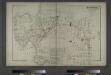
Astoria. Part of Long Island City, Town of Newtown, Queens Co. L.I.
from Atlas of Long Island, New York. From recent and actual surveys and records.
Map of the Village of Astoria, queens Co., N.Y.
From Queens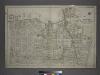
[Plate 2: Bounded by (East River) Vernon Avenue, Boulevard, Fulton Avenue, Mill Street, Orchard Street, Boulevard, Hoyt Avenue, Barclay Street, Woolsey Avenue, Rapelje Avenue and Freeman Avenue.]
from Atlas of the city of New York, borough of Queens, Long Island City, Newtown, Flushing, Jamaica, Far Rockaway, from actual surveys and official plans / by George W. and Walter S. Bromley.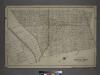
[Plate 4: Bounded by Rapelje Avenue, Woolsey Avenue, Flushing Avenue, Old Bowery Bay Road, Woodside Avenue, Middleburg Avenue, Celtic (Woodside) Avenue, Foster Avenue, Laurel Hill Avenue, Skillman Avenue, Harold Avenue and Jackson Avenue.]
from Atlas of the city of New York, borough of Queens, Long Island City, Newtown, Flushing, Jamaica, Far Rockaway, from actual surveys and official plans / by George W. and Walter S. Bromley.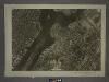
9A - N.Y. City (Aerial Set).
from Sectional aerial maps of the City of New York / [photographed and assembled under the direction of the chief engineer, July 1st, 1924].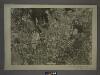
9D - N.Y. City (Aerial Set).
from Sectional aerial maps of the City of New York / [photographed and assembled under the direction of the chief engineer, July 1st, 1924].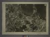
9B - N.Y. City (Aerial Set).
from Sectional aerial maps of the City of New York / [photographed and assembled under the direction of the chief engineer, July 1st, 1924].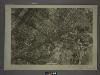
9C - N.Y. City (Aerial Set).
from Sectional aerial maps of the City of New York / [photographed and assembled under the direction of the chief engineer, July 1st, 1924].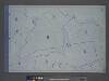
Area District Map Section No. 9; Area district map / City of New York, Board of Estimate and Apportionment.
from Area district map / City of New York, Board of Estimate and Apportionment. New York (N.Y.). Board of Estimate and Apportionment,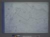
![Queens V. 2, Plate No. 33 [Map bounded by Grand Ave., 13th Ave., Jamaica Ave., 9th Ave.]](https://images-2.georeferencer.com/images/iiif/367730821065/full/,300/0/native.jpg)

