Maps of Canada

Map of the United States of America, the British provinces, Mexico, the West Indies and Central America, with part of New Granada and Venezuela / map drawn by Geo. W. Colton ; engraved by John M. Atwood ; border desig'd. & eng'd. by W.S. Barnard.
From Parts

Charte von Nord-America
1 : 20500000 Severní Amerika
CHARTE von NORD-AMERICA
1 : 20500000 Severní Amerika
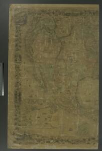
地理志略:北亞美麗加
地理志略 1903年,Alice S. Parker 此为用厦门闽南方言表述、罗马拼音书写的世界地理介绍性著作,介绍了清朝地理和世界六大洲地理概况。内有《大清國》图和《十八省》图,分别为全清和内地省级行政区划图。 2图,彩色,厦门方言罗马拼音,19.8 x 22.8 cm Harvard-Yenching | Rare Book | TA 2380 68.1,Hollis Number:008161909
Charte von Nordamerica
1 Karte : Kupferdruck ; 57 x 50 cm Reichard im Verlage des Industrie Comptoirs
Map of the country between Washington & Pittsburg refering to the contemplated Chesapeake & Ohio Canal and its general route and profile, October 1826 / reduced from the general map annexed to the report upon the comtemplated canal & drawn, b
from Parts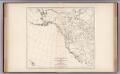
Facsimile: Greenhow's Map of Western and Middle North America.
1 : 14200000 Greenhow, Robert
Messico, ouvero Nuova-Spagna : che contiene il Nuovo Messico, la California con una parte de paesi adjacenti / G. Pitteri scr.
from Mexico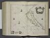
Paskaerte van Nova Granada en t'Eylandt California.
from De zee-atlas ofte water-wereld : waer in vertoont werden alle de zee-kusten van het bekende des aerd-bodems : seer dienstigh voor alle heeren en kooplieden, als oock voor alle schippers en stuurlieden / by Pieter Goos.
Carte De La Cote De L'Amerique.
1 : 5555555 Duflot de Mofras, Eugene
萬國通鑑:北亞美利加
美国传教士撰的向中国人介绍世界地理概况的著作,后有世界地图册1份,共13幅世界、大洲和区域地图,其中一幅题为《中國地圖》的清朝内地地图。 Sheffield, Devello Zelotos 謝衛樓 福州 : 美華書局
Fun map of Southern California.
Relief shown pictorially. Pictorial map. "Raymond Winters, 1935." All-Year Club of Southern California. [Los Angeles, Calif.?] : All-Year Club of Southern California,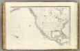
Oceanie 2.
1 : 15500000 Brue, Adrien Hubert, 1786-1832
Di-gyiu Du, Ng Da-tsiu Di-du[地舆图、五大洲地图]
Di-gyiu Du, Ng Da-tsiu Di-du[地舆图、五大洲地图] 1853年,Martin, W. A. P. (William Alexander Parsons) 美国长老会传教士丁韪良用罗马拼音标注宁波方言编写的世界地理著作,对地球和各大洲进行介绍。内有东西半球图、亚洲图、欧洲图、非洲图、北美洲图、南美洲图、地中海附近图、清内地十八省图、浙江省图、宁波附近图等。 10图,墨刻本,罗马拼音标注宁波方言,图幅不一,约39 x 49.5 cm Harvard-Yenching | Rare Book | TA 2370 92,Hollis Number:008156153
Ornamental map of the United States & Mexico / Barritt sc.
from Parts
North America, 1782.
1 : 28000000 Jefferys, Thomas
Uebersichts-Karte der ethnographischen Verhältnisse von Asien und von den angrenzenden Theilen Europa'sbearbeitet und herausgegeben mit Unterstützung der kaiserlichen Akademie der Wissenschaften in Wien von Vinzenz v. Haardt
Hartenthurn, Vincenz
Louisiana.
1 : 21000000 Lewis, Samuel
Louisiana.
1 : 21000000 Lewis, Samuel
Central America and Yucatan (Mexico).
from The cerographic atlas of the United States. By Sidney E. Morse, A.M., and Samuel Breese, A.M.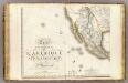
Amerique Septentrionale 3.
1 : 7500000 Brue, Adrien Hubert, 1786-1832
Standard American Map.
1 : 3168000 Monk, Jacob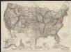
United States showing routes of principal explorers and early roads and highways
1 : 6000000 Berthrong, I. P. United States. General Land Office
North America, agreeable to the most approved maps and charts / by Thos. Conder.
from Parts Thomas Conder,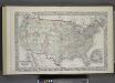
Map of The United States, and Territories. Together with Canada & c. ; Island of Newfoundland
from Atlas of Schuyler County, New York : from actual surveys by and under the direction of Beach Nichols.
Composite: Map of Louisiana and Mexico.
1 : 4300000 Tardieu, P.F.
Facsimile: Walch's North America (portion).
1 : 13000000 Walch, Joh.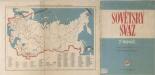
Sovětský svaz v mapách