Maps of Liberty Island

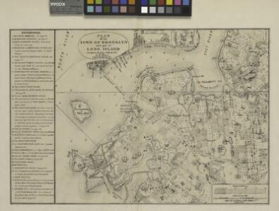
Plan of the town of Brooklyn and part of Long Island.
From Brooklyn
Plan of the city of New York in North America : surveyed in the years 1766 & 1767 / B. Ratzer, lieutt. in His Majestys 60th or Royal American Regt. ; Thos. Kitchin, sculpt., engraver to His Late Royal Highness, the Duke of York, &c.
from Charts and maps
Plan of the city of New York in North America : surveyed in the years 1766 & 1767 / B. Ratzer, lieutt. in His Majestys 60th or Royal American Regt. ; Thos. Kitchin, sculpt., engraver to His Late Royal Highness, the Duke of York, &c.
from Manhattan
Plan of the city of New York in North America : surveyed in the years 1766 & 1767 / B. Ratzer, lieutt. in His Majestys 60th or Royal American Regt. ; Thos. Kitchin, sculpt., engraver to His Late Royal Highness, the Duke of York, &c.
from Manhattan
Topographical map of the city of Brooklyn as reduced from the original maps on file showing farm lines, modern improvements, etc.
From Brooklyn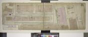
Double Page Plate No. 8; [Map bounded by Hamilton Ave., Bowne St., Imlay St., Commerce St., Ewen St., Ferris St.; Including Wolcott St., Sullivan St., King St., North Pier St., South Pier St.]
from Insurance maps of the warehouses, &c., in Brooklyn from the Navy yard to Partition Street.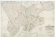
Map of the city of Brooklyn, and village of Williamsburg : showing the size of blocks and width of streets as laid out by the Commissioners, the old farm lines, water line, and all recent changes in streets / laid down from accurate surveys & documen
from Brooklyn
Lower Manhattan, The Battery, Wall Street, Civic Center, Governor's Island.
From District 1
Map of the city of New York : with the adjacent cities of Brooklyn & Jersey City, & the village of Williamsburg / drawn & engraved by John M. Atwood, 145 Fulton St., N.Y.
from Manhattan
Topographical map of New York City, County and vicinity : showing old farm lines &c. / based on Randells and other official surveys, drawings and modern surveys by J.F. Harrison & T. Magrane ; printed by C. Wadlow.
from (A-Z)
Topographical Atlas Of The City Of New York
1 : 12000 Viele, Egbert L.
Map of the City of New-York with part of Brooklyn and Williamsburgh : population in the year 1850: 450,000 inhabitants / D. Völker, sc.
from Manhattan
Map of the city of New York : with the adjacent cities of Brooklyn & Jersey City, & the village of Williamsburg / drawn & engraved by Story & Atwood, 151 Fulton St., N.Y.
from Manhattan
Map of the city of New York with the adjacent cities of Brooklyn and Jersey City, and the village of Williamsburg
1 : 14000 Story & Atwood H. Phelps
Map of the city of New-York / drawn by D.H. Burr, for "New York as it is, in 1834" ; engraved by S. Stiles & Co., New York.
from Manhattan
Height District Map Section No. 12
from Height district map / City of New York, Board of Estimate and Apportionment.
Use District Map Section No. 16
from Use district map / City of New York, Board of Estimate and Apportionment.
Plan of New York &c.
Mitchell, Samuel Augustus Jr.
Use District Map Section No. 12
from Use district map / City of New York, Board of Estimate and Apportionment.
Topographical atlas of the city of New York, including the annexed territory showing original water courses and made land. / prepared under the direction of Egbert L. Viele.
From Topographical atlas of the city of New York, including the annexed territory showing original water courses and made land
Area District Map Section No. 16
from Area district map / City of New York, Board of Estimate and Apportionment.
Map Of The City Of New York
1 : 12500 Ensign, Bridgman & Fanning
City of New-York / by David H. Burr.
from Manhattan
This actual map and comparative plans showing 88 years growth of the City of New York : is inscribed to the citizens by the proprietor, David Longworth / G.B. King sc. N.Y. 1817 ; engraved by Jas. D. Stout.
from Manhattan
New York S.
1 : 21120 Letts, Son & Co.
South Brooklyn, Park Slope, Brooklyn heights, Cobble Hill, Boerum Hill, Carroll Gardens, Red Hook, Gowanus, Windsor Terrace. (cont.)
From District 6
New map of the city of New York with part of Brooklyn & Williamsburg / by J. Calvin Smith ; engraved on steel by Stiles, Sherman & Smith.
from Manhattan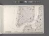
Area District Map Section No. 12
From Area district map.
New-York.
from The American traveller ; or, Guide through the United States, containing brief notices of the several states, cities, principal towns, canals and rail roads, etc. ; with tables of distances by stage, canal and steam boat routes ... by H.S. Tanner.