Maps of Kings County

Brooklyn V. 12, Plate No. 1 [Map bounded by Bay 8th St., Warehouse Ave., 16th Ave.]
From Atlas 97. Vol. 12, 1906.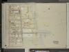
Brooklyn, Vol. 6, Double Page Plate No. 33; Part of Ward 30, Section 19; [Map bounded by 17th Ave., Warehouse Ave., Sharp Ave.; Including Bay Eighth St., Cropsey Ave., 14th Ave., Bath Ave.]
from Ward 30.
Part of the Town of New Utrecht, Kings Co., N.Y.
from Robinson's atlas of Kings County, New York : compiled from official records ... / under the direction of E. Robinson.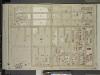
Brooklyn, Vol. 6, Double Page Plate No. 32; Part of Ward 30, Section 19; [Map bounded by 83rd St., 17th Ave., Bath Ave., 14th Ave.; Including Bayfifth St., 86th St., 13th Ave.]
from Ward 30.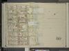
Brooklyn, Vol. 6, Double Page Plate No. 34; Part of Ward 30, Section 19; [Map bounded by 20th Ave., Warehouse Ave., 17th Ave., Rutherford Pl., Benson Ave.]
from Ward 30.
Double Page Plate No. 24: [Bounded by (Dyker Beach Park) Bay 8th Street, Fourteenth Avenue, 86th Street, Twelfth Avenue, 81st Street, Seventeenth Avenue, 86th Street, Bay 14th Street, Cropsey Avenue, Seventeenth Avenue and Warehouse Avenue.]
from Atlas of the Brooklyn borough of the City of New York : originally Kings Co.; complete in three volumes ... based upon official maps and plans ... / by and under the supervision of Hugo Ullitz, C.E.
Double Page Plate No. 23: [Bounded by (U.S. Government Reservation) Fort Hamilton Avenue, 86th Street, Bay 2nd Street, Benson Avenue, Delaplaine Street, Atlantic Avenue, (Dyker Beach Park) Seventh Avenue, 170th Street, Battery Avenue, Cropsey Avenue, Dah
from Atlas of the Brooklyn borough of the City of New York : originally Kings Co.; complete in three volumes ... based upon official maps and plans ... / by and under the supervision of Hugo Ullitz, C.E.
Part of the Town of New Utrecht, Kings Co., N.Y.
from Robinson's atlas of Kings County, New York : compiled from official records ... / under the direction of E. Robinson.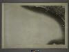
28A - N.Y. City (Aerial Set).
from Sectional aerial maps of the City of New York / [photographed and assembled under the direction of the chief engineer, July 1st, 1924].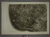
22C - N.Y. City (Aerial Set).
from Sectional aerial maps of the City of New York / [photographed and assembled under the direction of the chief engineer, July 1st, 1924].
Map of sewer district of Bath Beach and Bensonhurst-by-the-sea.
From Brooklyn
Area District Map Section No. 28
from Area district map / City of New York, Board of Estimate and Apportionment.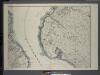
General map of the borough of Richmond (Staten Island) in the city of New York : showing in addition to the existing topographical features of the borough a tentative and preliminary plan for a street system of the same.
from Staten Island
Coney Island, Gravesend, Sea Gate. (cont.)
From District 13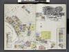
Insurance Maps of Brooklyn New York Sanborn Perris map co. 113 Broadway, New York. Volume "B" 1895.
From Atlas 62. Vol. B, 1895.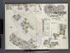
Insurance Maps of Brooklyn New York Sanborn Perris map co. 113, Broadway, New York. Volume "A" 1893.
From Atlas 61. Vol. A, 1893.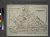
Gravesend. Kings Co. L.I.
from Atlas of Long Island, New York. From recent and actual surveys and records.
Index to Volume Seven. Atlas of the Borough of Brooklyn. Sections 20, 21 & 22. Ward 31. City of New York. E. Belcher Hyde, 97 Liberty St., Brooklyn Borough. 1907.
from Ward 31.
The Narrows
1 : 24000
The Narrows
1 : 24000
The Narrows
1 : 24000
The Narrows
1 : 24000
The Narrows
1 : 24000
The Narrows
1 : 24000
The Narrows
1 : 24000
The Narrows
1 : 24000
The Narrows
1 : 24000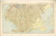
Hammods Atlas of New York City and the metropolitan district

Bath, Town on New Utrecht, Kings Co.
from Atlas of Long Island, New York. From recent and actual surveys and records.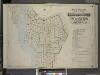
![Brooklyn V. 12, Plate No. 1 [Map bounded by Bay 8th St., Warehouse Ave., 16th Ave.]](https://images-2.georeferencer.com/images/iiif/605876893995/full/,300/0/native.jpg)

