Maps of Kings County
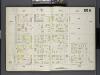
Brooklyn, V. 8, Double Page Plate No. 204 [Map bounded by Van Sicklen Ave., Belmont Ave., New Jersey Ave., Atlantic Ave.]
From Atlas 86. Vol. 8, 1887.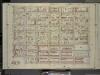
Brooklyn, Vol. 4, Double Page Plate No. 9; Part of Ward 26; Sections 12 & 13; [Map bounded by Ashford St., Dumont Ave., Wyona St.; Including Glenmore Ave., Bradford St., Liberty Ave.]
from Wards 26 and part of 29 & 32.
Brooklyn V. 8, Plate No. 60 [Map bounded by Sutter Ave., Wyona St., Dumont Ave., Pennsylvania Ave.]
From Atlas 87. Vol. 8, 1904.
Brooklyn V. 8, Plate No. 44 [Map bounded by Liberty Ave., Warwick St., Belmont Ave., Hendrix St.]
From Atlas 87. Vol. 8, 1904.
Plate 38: Bounded by Jefferson Street, Duryea Avenue, Henry Avenue, Atlantic Avenue, Williams Place, Jamaica Turnpike, Broadway, Cactus Place, and Highland Boulevard.
from Robinson's atlas of the city of Brooklyn, New York : embracing all territory within its corporate limits; from official records ... / by and under the supervision of E. Robinson and R.H. Pidgeon, civil engineers.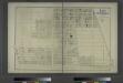
Portion of East New York. New Lots Tn. Kings Co. L.I. [Truxton Street to Bay Avenue, Hopkinson avenue to Butler Avenue.]
from Atlas of Long Island, New York. From recent and actual surveys and records.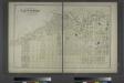
Portion of East New York. New Lots Tn., Kings Co. L.I.
from Atlas of Long Island, New York. From recent and actual surveys and records.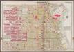
Plate 38: [Bounded by Snediker Avenue, Liberty Avenue, Van Sindren Avenue, Conway Street, Bushwick Avenue, (Evergreen Cemetery) Highland Boulevard, Barbey Street and Dumont Avenue.]; Atlas of the borough of Brooklyn, city of New York: from actual surveys and official plans by George W. and Walter S. Bromley.
from Atlas of the borough of Brooklyn, city of New York : from actual surveys and official plans by George W. and Walter S. Bromley. G.W. Bromley & Co.,
Part of Ward 26. Land Map Sections, Nos. 12 & 13. Volume 1, Brooklyn Borough, New York City.
from Atlas of the Brooklyn borough of the City of New York : originally Kings Co.; complete in three volumes ... based upon official maps and plans ... / by and under the supervision of Hugo Ullitz, C.E.
Double Page Plate No. 43: [Bounded by Pitkin Avenue, Berriman Street, New Lots Avenue and Williams Avenue.]
from Atlas of the Brooklyn borough of the City of New York : originally Kings Co.; complete in three volumes ... based upon official maps and plans ... / by and under the supervision of Hugo Ullitz, C.E.
Brooklyn, Vol. 4, Double Page Plate No. 6; Part of Ward 26; Sections 12; [Map bounded by Glenmore Ave., Wyona St.; Including Dumont Ave., Powell St.]
from Wards 26 and part of 29 & 32.
Brooklyn, Vol. 4, Double Page Plate No. 7; Part of Ward 26; Sections 12; [Map bounded by East New York Ave., Jamaica Ave., Bradford St.; Including Glenmore Ave., Powell St.]
from Wards 26 and part of 29 & 32.
Brooklyn, Vol. 4, Double Page Plate No. 8; Part of Ward 26; Sections 12 & 13; [Map bounded by Ashford St., Liberty Ave., Bradford St., Jamaica Ave.; Including Miller Ave., Highland Blvd., Warwick St.]
from Wards 26 and part of 29 & 32.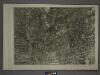
17B - N.Y. City (Aerial Set).
from Sectional aerial maps of the City of New York / [photographed and assembled under the direction of the chief engineer, July 1st, 1924].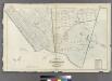
Plate 34: Part of Wards 23 & 25. City of Brooklyn.
from Atlas of the entire city of Brooklyn, complete in one volume. From actual surveys and official records by G. W. Bromley & Co.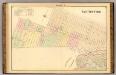
Sec. 9 East New York.
1 : 6000 Fulton, Henry; J.B. Beers & Co.
Plate 39: Part of Ward 26. Brooklyn, N.Y.
from Robinson's atlas of the city of Brooklyn, New York : embracing all territory within its corporate limits; from official records ... / by and under the supervision of E. Robinson and R.H. Pidgeon, civil engineers.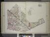
Brooklyn, Vol. 1, Double Page Plate No. 21; Part of Wards 25, 26 & 28, Sections 6 &11; [Map bounded by Evergreen Ave., Granite St., Furman Ave., Aberdeen St., De Sales Pl., Vanderveer St., Stewart St., Bushwick Ave., Highland Blvd.; Including Miller A...
From Volume 1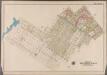
Plate 43: [Bounded by Stanley Ave., Miller St., Vienna Ave., Van Sicklen Ave., Dumont Ave., Barbey St., Sutter Ave., Milford St., New Lots Ave., Montauk Ave., Hegeman Ave., Berriman St., Vienna Ave., Shepherd Ave., Cozine Ave., Linwood St., Vandalia Ave. & (Fresh Creek) Louisiana Ave.]; Atlas of the borough of Brooklyn, city of New York: from actual surveys and official plans by George W. and Walter S. Bromley.
from Atlas of the borough of Brooklyn, city of New York : from actual surveys and official plans by George W. and Walter S. Bromley. G.W. Bromley & Co.,
Double Page Plate No. 21: [Bounded by Evergreen Avenue, Central Avenue, Bushwick Avenue, (Evergreen Cemetery) Boulevard, Miller Avenue, Jamaica Avenue, East New York Avenue, Atlantic Avenue, Rockway Avenue and Cooper Street.]
from Atlas of the Brooklyn borough of the City of New York : originally Kings Co.; complete in three volumes ... based upon official maps and plans ... / by and under the supervision of Hugo Ullitz, C.E.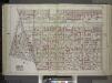
Brooklyn, Vol. 1, Double Page Plate No. 20; Part of Wards 24, 26 & 32, Sections 5-12; [Map bounded by Williams Ave., Riverdale Ave., Bristol St., East New York Ave.; Including Rockaway Ave., Atlantic Ave., East New York Ave.] / by and under the direct...
From Volume 1
Plate 37: Part of Ward 26. Brooklyn, N.Y.
from Atlas of the city of Brooklyn, New York.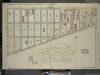
Brooklyn, Vol. 4, Double Page Plate No. 10; Part of Ward 26; Sections 12 & 13; [Map bounded by Dumont Ave., Warwick St., New Lots Ave., Georgia Ave.]; Sub Plan; [Map bounded by Boundary Line of the Borough of Brooklyn and Queens, Elderts Lane;
from Wards 26 and part of 29 & 32.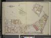
Brooklyn, Vol. 3, Double Page Plate No. 32; Part of Wards 28 & 26, Section 11; [Map bounded by Highland Blvd., Vermont St.; Including Jamaica Ave. (Norman Pl.), Broadway, Granite St.]; Sub Plan No. 1; [Map bounded by Highland Blvd., Mil
from Wards 13, 14, 15, 16, 17, 18, 19, 27 & 28.
Double Page Plate No. 20: [Bounded by Williams Avenue, Riverdale Avenue, Rockaway Avenue, Hunter Fly Road, Bristol Street, Sutter Avenue, Chester Street, East New York Parkway, Rockaway Avenue and Atlantic Avenue.]
from Atlas of the Brooklyn borough of the City of New York : originally Kings Co.; complete in three volumes ... based upon official maps and plans ... / by and under the supervision of Hugo Ullitz, C.E.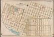
Plate 42: [Bounded by Riverdale Avenue, Hinsdale Street, Dumont Avenue, Vansiclen Avenue, Stanley Avenue, Louisiana Avenue, Warehouse Street, Williams Avenue, Vienna Avenue, Thatford Street, Hegeman Street & Rockaway Avenue.]; Atlas of the borough of Brooklyn, city of New York: from actual surveys and official plans by George W. and Walter S. Bromley.
from Atlas of the borough of Brooklyn, city of New York : from actual surveys and official plans by George W. and Walter S. Bromley. G.W. Bromley & Co.,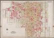
Plate 37: [Bounded by Park Place, East New York Avenue, Liberty Avenue, Snediker Avenue, Dumont Avenue, Hinsdale Street, Riverdale Avenue, Rockway Avenue, Dumont Avenue, Amboy Street, Blake Avenue, Barret Street, Sutter Avenue, Howard Avenue, East New York Avenue and Saratoga Avenue.]; Atlas of the borough of Brooklyn, city of New York: from actual surveys and official plans by George W. and Walter S. Bromley.
from Atlas of the borough of Brooklyn, city of New York : from actual surveys and official plans by George W. and Walter S. Bromley. G.W. Bromley & Co.,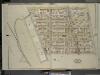
Brooklyn, Vol. 4, Double Page Plate No. 13; Part of Ward 26; Sections 13; [Map bounded by Hale Ave., Atlantic Ave., Ashford St.; Including Jamaica Ave., Warwick St., Sunnyside Ave.]
from Wards 26 and part of 29 & 32.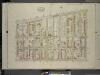
Brooklyn, Vol. 4, Double Page Plate No. 12; Part of Ward 26; Sections 13; [Map bounded by Atlantic Ave., Fountain Ave.; Including Pitkin Ave., Ashford St.]
from Wards 26 and part of 29 & 32.
![Brooklyn, V. 8, Double Page Plate No. 204 [Map bounded by Van Sicklen Ave., Belmont Ave., New Jersey Ave., Atlantic Ave.]](https://images-2.georeferencer.com/images/iiif/799777069310/full/,300/0/native.jpg)

