Maps of Kings County
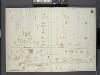
Brooklyn, V. 7, Double Page Plate No. B [Map bounded by Fenimore St., Ocean Ave., Malbone Ave.]
From Atlas 83. Vol. 7, 1888.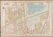
Plate 16: [Bounded by Terrace Place, 11th Avenue, Prospect Avenue, Seeley Street, (Prospect Park) Coney Island Avenue, Parkside Avenue, Ocean Avenue, Albemarle Road, Church Avenue, West Street, Fort Hamilton Avenue and (Greenwood Cemetery) Gravesend Avenue.]; Atlas of the borough of Brooklyn, city of New York: from actual surveys and official plans by George W. and Walter S. Bromley.
from Atlas of the borough of Brooklyn, city of New York : from actual surveys and official plans by George W. and Walter S. Bromley. G.W. Bromley & Co.,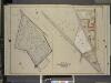
Brooklyn, vol. 1, Double Page Plate No. 19; Part of Wards 9 & 29, Section 4; [Map bounded by crown St., Franklin Ave., Flatbush Ave.; Including Washington Ave.]; Sub Plan; [Map bounded by Flatbush Ave., Ocean Ave., Caton Ave.; Including
from Wards 1, 2, 3, 4, 5, 6, 8, 9, 10, 12 & 22.
Sec. 10. Brooklyn map.
1 : 6000 Fulton, Henry; J.B. Beers & Co.
Part of Wards 9, 22 & 29. Land Map Sections, No. 4 & 6, Volume 1, Brooklyn Borough, New York City.
from Atlas of the Brooklyn borough of the City of New York : originally Kings Co.; complete in three volumes ... based upon official maps and plans ... / by and under the supervision of Hugo Ullitz, C.E.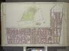
Brooklyn, Vol. 1, Double Page Plate No. 13; Part of Ward 22, Section 4; [Map bounded by Prospect Park West, 15th St., Coney Island Rd., 11th Ave.; Including Prospect Ave., 7th Ave., Carroll St]; Sub Plan [Map bounded by Ocean Ave., Gaton Ave., Coney I...
From Volume 1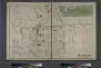
Flatbush. Town of Flatabush, Kings Co. L.I. - Prospect Park.
from Atlas of Long Island, New York. From recent and actual surveys and records.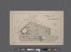
University Park, Brooklyn, N. Y., general improvement plan.
From Brooklyn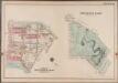
Plate 36: Prospect Park [Bounded by (Institute Park) Flatbush Avenue, Ocean Avenue, Caton Avenue, Coney Island Avenue, Seeley Avenue, Prospect Avenue, Terrace Place, (Greenwood Cemetery) Gavesend Avenue, 20th Street and Prospect Park West.]; Atlas of the borough of Brooklyn, city of New York: from actual surveys and official plans by George W. and Walter S. Bromley.
from Atlas of the borough of Brooklyn, city of New York : from actual surveys and official plans by George W. and Walter S. Bromley. G.W. Bromley & Co.,
Part of Ward 29. Land Map Sections, Nos. 4, 5, & 16. Volume 2, Brooklyn Borough, New York City.
from Atlas of the Brooklyn borough of the City of New York : originally Kings Co.; complete in three volumes ... based upon official maps and plans ... / by and under the supervision of Hugo Ullitz, C.E.
Plate 1: [Bounded by Montgomery Street, New York Avenue, Malbone Street, Kingston Avenue, Fenimore Street, Ocean Avenue and Flatbush Avenue.]
from Robinson's atlas of Kings County, New York : compiled from official records ... / under the direction of E. Robinson.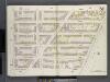
Brooklyn V. 2, Double Page Plate No. 51 [Map bounded by Clermont Ave., Atlantic Ave., S.Portland Ave., Lafayette Ave.]
From Atlas 66. Vol. 2, 1887.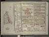
Brooklyn, Vol. 5, Double Page Plate No. 1; Part of Wards 29, Section 16; [Map bounded by Lincoln Road, Rogers Ave., Clarkson Ave.; Including Woodruff Ave., Ocean Ave.]; Sub Plan; [Map bounded by Flatbush Ave., Lincoln Road, Ocean Ave.; Including
from Ward 29 and part of 32.
Plate 27: Part of Wards 9 & 24. Brooklyn, N.Y.
from Robinson's atlas of the city of Brooklyn, New York : embracing all territory within its corporate limits; from official records ... / by and under the supervision of E. Robinson and R.H. Pidgeon, civil engineers.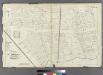
Plate 11: Part of Wards 9 & 24. City of Brooklyn.
from Atlas of the entire city of Brooklyn, complete in one volume. From actual surveys and official records by G. W. Bromley & Co.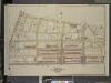
Brooklyn, Vol. 2, Double Page Plate No. 26; Part of Wards 24 & 29, Section 5; [Map bounded by Montgomery St., New York Ave., Lincoln Road; Including Lefferts St., Sterling St., Malbone St., Franklin Ave.]
from Wards 7, 11, 20, 21, 23, 24 & 25.
Brooklyn, Section 10; [Including Ward 22]
from Farm line map of the city of Brooklyn, from official records and surveys; comp. and drawn by Henry Fulton.
16D - N.Y. City (Aerial Set).
from Sectional aerial maps of the City of New York / [photographed and assembled under the direction of the chief engineer, July 1st, 1924].
[Sheet 2: Map encompassing Prospect Park, Windsor Terrace, Park Slope, Carroll Gardens, Gowanus Canal, Fort Greene, Clinton Hill and Prospect Heights.]
from Map of the city of Brooklyn : being the former cities of Brooklyn & Williamsburgh and the town of Bushwick, as consolidated January 1st, 1855 by an act of the legislature of the State of New York ... showing also a part of the City of New York.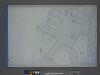
Height District Map Section No. 16; Height district map / City of New York, Board of Estimate and Apportionment.
from Height district map / City of New York, Board of Estimate and Apportionment. New York (N.Y.). Board of Estimate and Apportionment,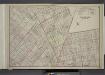
Brooklyn, Double Page Section 5; [Including Wards 7, 9, 20, 22, 23]
from Farm line map of the city of Brooklyn, from official records and surveys; comp. and drawn by Henry Fulton.
Plan of the city of Brooklyn, L.I. / by William Perris.
from Brooklyn
Plan of the city of Brooklyn, L.I. / by William Perris.
from Brooklyn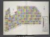
Key
From Atlas 92. Vol. 10, 1905.
[Volume 2 Index Map]
from Maps of the city of Brooklyn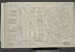
Vol. 5. Plate, C. [Map bound by Poplar St., Sands St., Jay St., Pearl St., Johnson St., Pierrepont St., East River; Including Middagh St., High St., Cranberry St., Orange St., Nassau St., Pineapple St., Concord St., Clark St., Tillary St., Love Lane, Fur
from Detailed estate and old farm line atlas of the city of Brooklyn : complete in six volumes ... from official records, private plans, and actual surveys ... / by G.M. Hopkins, C.E.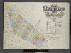
Insurance Maps of the Brooklyn city of New York Volume Five. Published by the Sanborn map co. 117, Broadway, New York. 1888.
From Atlas 77. Vol. 5, 1888.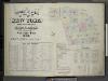
Insurance Maps of The City of New York Surveyed and Published by Perris & Browne 55 Liberty St. Volume Two. 1868.; Street Index.
from Insurance maps of the city of New York.
Area District Map Section No. 16
from Area district map / City of New York, Board of Estimate and Apportionment.
![Brooklyn, V. 7, Double Page Plate No. B [Map bounded by Fenimore St., Ocean Ave., Malbone Ave.]](https://images-2.georeferencer.com/images/iiif/355580442381/full/,300/0/native.jpg)

