Maps of Kings County

Brooklyn Vol. A Plate No. 97 [Map bounded by Putnam Ave., Cypress Hills Plank Road, Weirfield St.]
From Atlas 61. Vol. A, 1893.
Queens V. 3, Plate No. 9 [Map bounded by Schaeffer Ave., Putnam Ave., Wyckoff Ave., Eldert Ave., Irving Ave.]
From Atlas 137. Vol. 3, 1902.
Brooklyn Vol. A Plate No. 98 [Map bounded by Willow St., Cypress Hills Plank Road, Norman St., Covert St.]
From Atlas 61. Vol. A, 1893.
Brooklyn Vol. A Plate No. 96 [Map bounded by Woodbine St., Onderdonk Ave., Elm Ave., North St., St.Nicholas Ave.]
From Atlas 61. Vol. A, 1893.
Brooklyn V. 9, Plate No. 52 [Map bounded by St. Nicholas Ave., Madison St., Irving Ave., Linden St.]
From Atlas 90. Vol. 9, 1907.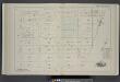
Vol. 2. Plate, Q. [Map bound by Magnolia St., City Line, Weirfield St., Central Ave.; Including Palmetto St., Woodbine St., Ivy St., Jacob St., Cornelia St., Vigelius St., Duryea St., Hamburg St., Knickerbocker Ave., Irving Ave., Wyckoff Ave., Myrtle Ave
from Detailed estate and old farm line atlas of the city of Brooklyn : complete in six volumes ... from official records, private plans, and actual surveys ... / by G.M. Hopkins, C.E.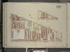
Brooklyn, Vol. 3, Double Page Plate No. 30; Part of Ward 28, Section 11; [Map bounded by Boundry line of borough of Brooklyn and Queens, Schaeffer St., Kinckerbocker Ave.; Including Palmetto St., Myrtle Ave.]; Sub Plan; {map bounded by Schaeffer
from Wards 13, 14, 15, 16, 17, 18, 19, 27 & 28.
Brooklyn, V. 9, Double Page Plate No. 266 [Map bounded by Irving Ave., Pilling St., Central Ave., Palmetto St.]
From Atlas 89. Vol. 9, 1888.
Plate 21: Part of Ward 18. Brooklyn, N.Y.
from Atlas of the city of Brooklyn, New York.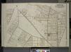
Queens, Vol. 2, Double Page Plate No. 24; Part of Ward Two East Williamsburgh (Evergreen, Ridge Woodheights, Germaniaheights), (St. James Park and Glendale); [Map bounded by Cooper Ave., Irving Ave., Boundary Line between Borough of Qu
from First and second wards: Long Island City and Newtown.
Part of Wards 27 & 28. Land Map Section, No. 11, Volume 1, Brooklyn Borough, New York City.
from Atlas of the Brooklyn borough of the City of New York : originally Kings Co.; complete in three volumes ... based upon official maps and plans ... / by and under the supervision of Hugo Ullitz, C.E.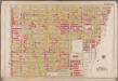
Plate 21: [Bounded by Harman Street, St. Nicholas Avenue, Gates Avenue, Wyckoff Avenue, Cornelia Street, Irving Avenue, Halsey Street, Broadway, Van Buren Street and Bushwick Avenue.]; Atlas of the borough of Brooklyn, city of New York: from actual surveys and official plans by George W. and Walter S. Bromley.
from Atlas of the borough of Brooklyn, city of New York : from actual surveys and official plans by George W. and Walter S. Bromley. G.W. Bromley & Co.,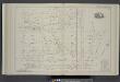
Vol. 2. Plate, O. [Map bound by Stanhope St., Wyckoff Ave., Greene Ave., St. Nicholas Ave., Magnolia St., Hamburg St.; Including Himrod St., Harman St., Bleecker St., Ralph St., Grove St., Linden St., Myrtle Ave., Knickerbocker Ave., Irving Ave.]
from Detailed estate and old farm line atlas of the city of Brooklyn : complete in six volumes ... from official records, private plans, and actual surveys ... / by G.M. Hopkins, C.E.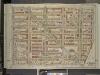
Brooklyn, Vol. 3, Double Page Plate No. 28; Part of Ward 28, Section 11; [Map bounded by Stanhope St., St.Nicholas Ave., Boundary Line Borough of Brooklyn and Queens; Including Palmetto St., Central Ave.]
from Wards 13, 14, 15, 16, 17, 18, 19, 27 & 28.
Brooklyn V. 9, Plate No. 44 [Map bounded by Irving Ave., Hancock St., Hamburg Ave., Madison St.]
From Atlas 90. Vol. 9, 1907.
Brooklyn Vol. A Plate No. 100 [Map bounded by Cypress Hills Plank Road, Myrtle Ave., Summerfield St.]
From Atlas 61. Vol. A, 1893.
Brooklyn Vol. A Plate No. 95 [Map bounded by Grove St., Onderdonk Ave., Woodbine St., St. Nicholas Ave.]
From Atlas 61. Vol. A, 1893.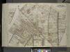
Queens, Vol. 2, Double Page Plate No. 35; Part of Ward Two East Williamsburgh; [Map bounded by Cooper Ave., Moffatt St., Irving Ave., Boundary line between borough of Queens and Brooklyn, Wyckof Ave., Madison St. (Ivy St.), Putnam Ave., Forest
from First and second wards: Long Island City and Newtown.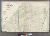
[Plate 32: Bounded by Greene Avenue, Bushvick Avenue, Himrod Street, Centrat Avenue, Greene Avenue, Myrtle Avenue, Bleecker Street, Wyckoff Avenue, Cornelia Street, Irving Avenue, Eldert Street, Knickerbocker Avenue, Schaffer Street, Broadway, Hopkinson
from Atlas of the entire city of Brooklyn, complete in one volume. From actual surveys and official records by G. W. Bromley & Co.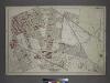
Part of the Borough of Queens, New town, Ward 2.
from Atlas of the city of New York, borough of Queens, Long Island City, Newtown, Flushing, Jamaica, Far Rockaway, from actual surveys and official plans / by George W. and Walter S. Bromley.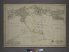
Part of the Borough of Queens, New town, Ward 2.
from Atlas of the city of New York, borough of Queens, Long Island City, Newtown, Flushing, Jamaica, Far Rockaway, from actual surveys and official plans / by George W. and Walter S. Bromley.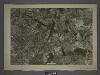
13D - N.Y. City (Aerial Set).
from Sectional aerial maps of the City of New York / [photographed and assembled under the direction of the chief engineer, July 1st, 1924].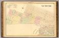
Sec. 9 East New York.
1 : 6000 Fulton, Henry; J.B. Beers & Co.
Plan of the city of Brooklyn, L.I. / by William Perris.
from Brooklyn
Plan of the city of Brooklyn, L.I. / by William Perris.
from Brooklyn
Sheet 4: Map encompassing Ocean Hill, Broasway Junction, Bushwick and Ridgewood.
from Map of the city of Brooklyn : being the former cities of Brooklyn & Williamsburgh and the town of Bushwick, as consolidated January 1st, 1855 by an act of the legislature of the State of New York ... showing also a part of the City of New York.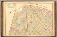
Sec. 7. Brooklyn map.
1 : 6000 Fulton, Henry; J.B. Beers & Co.
Brooklyn, Double Page Section 9; East New York; [Map bounded by Eldert Lane, Liberty Ave., Bennett Ave., New Lots Road, Duryea Ave., Centre Ave., Stmarks Ave., Saratoga Ave., Cooper PL., Mc. Dougal St.; Including Hopkinson Ave., Rockaway Ave., Gran
from Farm line map of the city of Brooklyn, from official records and surveys; comp. and drawn by Henry Fulton.
Brooklyn, Double Page Section 4; [Including Wards 16, 18, 19, 21, 25]
from Farm line map of the city of Brooklyn, from official records and surveys; comp. and drawn by Henry Fulton.
![Brooklyn Vol. A Plate No. 97 [Map bounded by Putnam Ave., Cypress Hills Plank Road, Weirfield St.]](https://images-2.georeferencer.com/images/iiif/337149579830/full/,300/0/native.jpg)

