Maps of Kings County
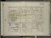
Brooklyn, Vol. 7, Double Page Plate No. 4; Part of Ward 31 & 32, Section 20; [Map bounded by Ocean Ave., Avenue M; Including E. 13th St., Avenue J]
from Ward 31.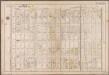
Plate 24: [Bounded by Avenue M., Coney Island Avenue, Elm Avenue, Bay Avenue, Cedar Avenue, Ocean Avenue, Avenue Q. and Gravesend Avenue.]; Atlas of the borough of Brooklyn, city of New York: from actual surveys and official plans by George W. and Walter S. Bromley.
from Atlas of the borough of Brooklyn, city of New York : from actual surveys and official plans by George W. and Walter S. Bromley. G.W. Bromley & Co.,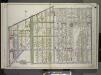
Brooklyn, Vol. 3, Double Page Plate No. 1; Part of Wards 30, 31 & 32, Section 20; [Map bounded by Foster Ave., Avenue G, Ocean Ave.; Including Avenue K, Ocean Parkway, Grave Send Ave.] / by and under the direction of Hugo Ullitz.
From Volume 3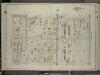
Brooklyn, Vol. 7, Double Page Plate No. 6; Part of Wards 30 & 31, Section 20; [Map bounded by Avenue M, Ocean Ave.; Including Avenue O, E. 9th St.]
from Ward 31.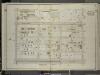
Brooklyn, Vol. 7, Double Page Plate No. 5; Part of Ward 31, Section 20; [Map bounded by E. 13th St., Avenue M; Including Ocean Parkway, Avenue J]
from Ward 31.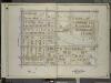
Brooklyn, Vol. 7, Double Page Plate No. 3; Part of Wards 31 & 32, Section 20; [Map bounded by Ocean Ave., Avenue J, E. 13th St.; Including Argyle Road, Avenue G]
from Ward 31.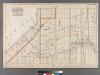
Plate 24: [Bounded by Avenue I, Ocean Avenue, Avenue O, 22nd Avenue, Bay Ridge Street, 21st Avenue and West Street.]
from Robinson's atlas of Kings County, New York : compiled from official records ... / under the direction of E. Robinson.
22D - N.Y. City (Aerial Set).
from Sectional aerial maps of the City of New York / [photographed and assembled under the direction of the chief engineer, July 1st, 1924].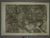
23C - N.Y. City (Aerial Set).
from Sectional aerial maps of the City of New York / [photographed and assembled under the direction of the chief engineer, July 1st, 1924].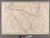
Plate 25: [Bounded by Avenue C, Ralph Avenue, Avenue L, Ocean Avenue, Avenue E, Avenue D and E. 31st Street.
from Robinson's atlas of Kings County, New York : compiled from official records ... / under the direction of E. Robinson.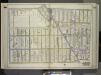
Brooklyn, Vol. 3, Double Page Plate No. 2; Part of Ward 32, Section 23; [Map bounded by Glenwood Road, E. 14th St., Avenue K; Including Flatbush Ave., Ocean Ave.] / by and under the direction of Hugo Ullitz.
From Volume 3
Part of the Town of Flatbush, Kings Co., N.Y.
from Robinson's atlas of Kings County, New York : compiled from official records ... / under the direction of E. Robinson.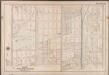
Plate 23:[Bounded by Avenue I., Ocean Avenue, Cedar Avenue, Bay Avenue, Elm Avenue, Coney Island Avenue, Avenue M. and Gravesend Avenue.]; Atlas of the borough of Brooklyn, city of New York: from actual surveys and official plans by George W. and Walter S. Bromley.
from Atlas of the borough of Brooklyn, city of New York : from actual surveys and official plans by George W. and Walter S. Bromley. G.W. Bromley & Co.,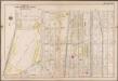
Plate 25: [Bounded by Avenue Q., Ocean Avenue, Avenue U. and Gravesend Avenue.]; Atlas of the borough of Brooklyn, city of New York: from actual surveys and official plans by George W. and Walter S. Bromley.
from Atlas of the borough of Brooklyn, city of New York : from actual surveys and official plans by George W. and Walter S. Bromley. G.W. Bromley & Co.,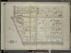
Brooklyn, Vol. 7, Double Page Plate No. 2; Part of Wards 30 & 31, Section 20; [Map bounded by Argyle Road, E. 13th St., Avenue J; Including Ocean Parkway, Foster Ave., Avenue G]
from Ward 31.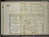
Brooklyn, Vol. 7, Double Page Plate No. 7; Part of Ward 31, Section 20; [Map bounded by E. 9th St., Avenue O, Gravesend Ave.; Including Avenue L, Ocean Parkway, Avenue M]
from Ward 31.
Coney Island, Gravesend, Sea Gate. (cont.)
From District 13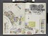
Insurance Maps of Brooklyn New York Sanborn Perris map co. 113 Broadway, New York. Volume "B" 1895.
From Atlas 62. Vol. B, 1895.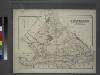
Gravesend. Kings Co. L.I.
from Atlas of Long Island, New York. From recent and actual surveys and records.
Index to Volume Seven. Atlas of the Borough of Brooklyn. Sections 20, 21 & 22. Ward 31. City of New York. E. Belcher Hyde, 97 Liberty St., Brooklyn Borough. 1907.
from Ward 31.
East Astoria, part of Long Island City, Queens Co.
from Atlas of Long Island, New York. From recent and actual surveys and records.
Flatlands. Kings Co. L.I.
From Atlas of Long Island, New York. From recent and actual surveys and records.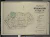
Index to Volume Five. Atlas of the Borough of Brooklyn. Sections 15 & 16. Ward 29 and part of 32. City of New York. E. Belcher Hyde, 97 Liberty St., Brooklyn Borough. 1906.
from Ward 29 and part of 32.
Flatlands. Kings Co. L.I.
from Atlas of Long Island, New York. From recent and actual surveys and records.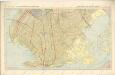
Hammods Atlas of New York City and the metropolitan district

Map of the City of Brooklyn as consolidated by an act of the Legislature of the Ste of New York . . . Constructed from the official maps of the Commissioners . . . Exhibiting the farm lines names of the original owners.
From Brooklyn
New Lots. Kings Co. L.I.
from Atlas of Long Island, New York. From recent and actual surveys and records.
Bath, Town on New Utrecht, Kings Co.
from Atlas of Long Island, New York. From recent and actual surveys and records.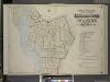
Index to Volume One, Atlas of the Borough of Brooklyn Sections 1, 2, 3 & 4. Wards 1, 2, 3, 4, 5, 6, 8, 9, 10, 12 & 22. City of New York. Published by E. Belcher Hyde, 97 Liberty St., Brooklyn. 1903.
from Wards 1, 2, 3, 4, 5, 6, 8, 9, 10, 12 & 22.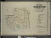
![Brooklyn, Vol. 7, Double Page Plate No. 4; Part of Ward 31 & 32, Section 20; [Map bounded by Ocean Ave., Avenue M; Including E. 13th St., Avenue J]](https://images-2.georeferencer.com/images/iiif/106512384726/full/,300/0/native.jpg)

