Maps of Kings County
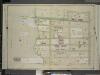
Brooklyn, Vol. 6, Double Page Plate No. 13; Part of Ward 30, Section 18; [Map bounded by 68th St., Ridge Blvd.; Including 75th St., Bay Ridge Parkway]
from Ward 30.
Plate 8: [Bounded by Mackay Place, Narrows Avenue, 71st Street, First Avenue, 72nd Street, Second Avenue, 73rd Street, Third Avenue, 74th Street, Fourth Avenue, 75th Street, Stewart Avenue, 89th Street, Third Avenue, 87th Street, First Avenue, 86th Stree
from Robinson's atlas of Kings County, New York : compiled from official records ... / under the direction of E. Robinson.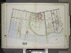
Brooklyn, Vol. 2, Double Page Plate No. 19; Part of Ward 30, Section 18; [Map bounded by 2nd Ave., Ridge Blvd.; Including 74th St., 60th St.] / by and under the direction of Hugo Ullitz.
From Volume 2.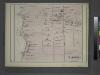
Bayridge. Town of New Utrecht, Kings Co.
from Atlas of Long Island, New York. From recent and actual surveys and records.
Part of Ward 30, Land Map Section, No. 18. Volume 2, Brooklyn Borough, New York City.
from Atlas of the Brooklyn borough of the City of New York : originally Kings Co.; complete in three volumes ... based upon official maps and plans ... / by and under the supervision of Hugo Ullitz, C.E.
Plate 7: [Bounded by 60th Street, Seventh Avenue, 66th Street, Stewart Avenue, 75th Street, Fourth Avenue, 72nd Street, Second Avenue, 71st Street, First Avenue, Mackay Place, Shore Road and New York Bay Pier Line.]
from Robinson's atlas of Kings County, New York : compiled from official records ... / under the direction of E. Robinson.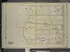
Brooklyn, Vol. 6, Double Page Plate No. 27; Part of Ward 30, Section 18; [Map bounded by 75th St., Ridge Blvd.; Including 83rd St., Bay Ridge Parkway]
from Ward 30.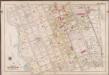
Plate 2: [Bounded by Mackay Pl., 1st Ave., 72nd St., 2nd Ave., 73rd St., 3rd Ave., 74th St., 4th Ave., 75th St., 6th Ave., 78th St., 5th Ave., 89th St., 3rd Ave., 88th St., 2nd Ave., 87th St., 1st Ave., 86th St. & Bayridge Pkwy.]; Atlas of the borough of Brooklyn, city of New York: from actual surveys and official plans by George W. and Walter S. Bromley.
from Atlas of the borough of Brooklyn, city of New York : from actual surveys and official plans by George W. and Walter S. Bromley. G.W. Bromley & Co.,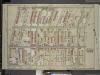
Brooklyn, Vol. 6, Double Page Plate No. 14; Part of Ward 30, Section 18; [Map bounded by 5th Ave., 18th St.; Including Ridge Blvd., Bay Ridge Ave.]
from Ward 30.
Brooklyn, Vol. 6, Double Page Plate No. 12; Part of Ward 30, Section 18; [Map bounded by 2nd Ave., Ridge Blvd., 68th St.; Including Shore Road, 60th St.]
from Ward 30.
Brooklyn V. 11, Plate No. 30 [Map bounded by Narrows Ave., 67th St., 2nd Ave., Bay Ridge Ave.]
From Atlas 95. Vol. 11, 1905.
Brooklyn Vol. A Plate No. 31 [Map bounded by New York Bay, 77th St., Narrows Ave., 82nd St.]
From Atlas 61. Vol. A, 1893.
Plan of Bay Ridge parkway.
From Brooklyn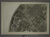
22A - N.Y. City (Aerial Set).
from Sectional aerial maps of the City of New York / [photographed and assembled under the direction of the chief engineer, July 1st, 1924].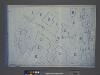
Area District Map Section No. 22; Area district map / City of New York, Board of Estimate and Apportionment.
from Area district map / City of New York, Board of Estimate and Apportionment. New York (N.Y.). Board of Estimate and Apportionment,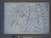
Use District Map Section No. 22; Use district map / City of New York, Board of Estimate and Apportionment.
from Use district map / City of New York, Board of Estimate and Apportionment. New York (N.Y.). Board of Estimate and Apportionment,
Height District Map Section No. 22; Height district map / City of New York, Board of Estimate and Apportionment.
from Height district map / City of New York, Board of Estimate and Apportionment. New York (N.Y.). Board of Estimate and Apportionment,
Key
From Atlas 95. Vol. 11, 1905.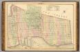
Sec. 6. Brooklyn map.
1 : 6000 Fulton, Henry; J.B. Beers & Co.
Plan of the city of Brooklyn, L.I. / by William Perris.
from Brooklyn
Jersey City, V. 1, Double Page Plate No. 24 [Map bounded by Ocean Ave., Linden Ave., Morris Canal, Avenue C] / compiled under the direction of and published by G.M. Hopkins Co.
From V. 1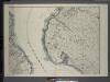
General map of the borough of Richmond (Staten Island) in the city of New York : showing in addition to the existing topographical features of the borough a tentative and preliminary plan for a street system of the same.
from Staten Island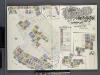
Insurance Maps of Brooklyn New York Sanborn Perris map co. 113, Broadway, New York. Volume "A" 1893.
From Atlas 61. Vol. A, 1893.
South Brooklyn, Park Slope, Brooklyn heights, Cobble Hill, Boerum Hill, Carroll Gardens, Red Hook, Gowanus, Windsor Terrace. (cont.)
From District 6
Plan of the city of New York in North America : surveyed in the years 1766 & 1767 / B. Ratzer, lieutt. in His Majestys 60th or Royal American Regt. ; Thos. Kitchin, sculpt., engraver to His Late Royal Highness, the Duke of York, &c.
from Manhattan
Topographical map of the city of Brooklyn as reduced from the original maps on file showing farm lines, modern improvements, etc.
From Brooklyn
Jersey City
1 : 24000
Jersey City
1 : 24000
Jersey City
1 : 24000
Jersey City
1 : 24000
![Brooklyn, Vol. 6, Double Page Plate No. 13; Part of Ward 30, Section 18; [Map bounded by 68th St., Ridge Blvd.; Including 75th St., Bay Ridge Parkway]](https://images-2.georeferencer.com/images/iiif/967628716905/full/,300/0/native.jpg)

