Maps of Kings County
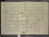
Brooklyn, Vol. 5, Double Page Plate No. 9; Part of Ward 29, Section 15; [Map bounded by E. 55th St., Tilden Ave. (Vernon Ave.); Including Schenectady Ave., Clarkson Ave.]
from Ward 29 and part of 32.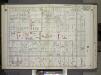
Brooklyn, Vol. 2, Double Page Plate No. 2; Part of Ward 29, Section 15; [Map bounded by E. New York Ave., E. 52nd St.; Including Church Ave., New York Ave.] / by and under the direction of Hugo Ullitz.
From Volume 2.
Part of Wards 29 & 32, Land Map Section, No. 15. Volume 2, Brooklyn Borough, New York City.
from Atlas of the Brooklyn borough of the City of New York : originally Kings Co.; complete in three volumes ... based upon official maps and plans ... / by and under the supervision of Hugo Ullitz, C.E.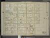
Brooklyn, Vol. 5, Double Page Plate No. 10; Part of Ward 29, Section 15; [Map bounded by Schenectady Ave., Tilden Ave. (Vernon Ave.); Including Snyder Ave., E. 38th St., Clarkson Ave.]
from Ward 29 and part of 32.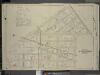
Brooklyn, Vol. 5, Double Page Plate No. 7; Part of Wards 29 & 32, Section 15; [Map bounded by Remsen Ave., Avenue B, Ralph Ave.; Including Tilden Ave. (Vernon Ave.), E. Fifty Fifth St., Lenox Road]; Sub Plan; [Map bounded by Remsen Ave., E. 57t
from Ward 29 and part of 32.
Part of Wards 29 & 32, Land Map Section, No. 15. Volume 2, Brooklyn Borough, New York City.
from Atlas of the Brooklyn borough of the City of New York : originally Kings Co.; complete in three volumes ... based upon official maps and plans ... / by and under the supervision of Hugo Ullitz, C.E.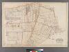
Part of the Towns of Flatbush and Flatlands, Kings Co., N.Y.
from Robinson's atlas of Kings County, New York : compiled from official records ... / under the direction of E. Robinson.
Brooklyn, Section 8; [Including Wards 24]
from Farm line map of the city of Brooklyn, from official records and surveys; comp. and drawn by Henry Fulton.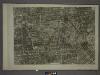
17C - N.Y. City (Aerial Set).
from Sectional aerial maps of the City of New York / [photographed and assembled under the direction of the chief engineer, July 1st, 1924].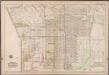
Plate 34: [Bounded by Ralph Avenue, E. 98th Street, Winthrop Avenue, E. 96th Street, Clarkson Avenue, E. 95th Street, Hunterfly Road, Broadway Avenue, Ralph Avenue, Clarkson Road, Canarsie Avenue, E. 49th Street, Snyder Avenue, E. 39th Street, Clarkson Avenue, Winthorp Street, Kingston Avenue and East New York Avenue.]; Atlas of the borough of Brooklyn, city of New York: from actual surveys and official plans by George W. and Walter S. Bromley.
from Atlas of the borough of Brooklyn, city of New York : from actual surveys and official plans by George W. and Walter S. Bromley. G.W. Bromley & Co.,
Brooklyn, Vol. 2, Double Page Plate No. 5; Part of Ward 29, Section 15; [Map bounded by Church Ave., E. 52nd St.; Including Clarendon Road, New York Ave.] / by and under the direction of Hugo Ullitz.
From Volume 2.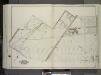
Brooklyn, Vol. 3, Double Page Plate No. 31; Part of Wards 29-32, Section 24; [Map bounded by Avenue D, E. 57th St., Beverley Rd., Remsen Ave.; Including Farragut Rd., Glenwood Rd., Utica Ave., E. 51st St.] / by and under the direction of Hugo Ullitz.
From Volume 3
Part of Ward 29. Land Map Sections, Nos. 5, 12, & 15. Volume 2, Brooklyn Borough, New York City.
from Atlas of the Brooklyn borough of the City of New York : originally Kings Co.; complete in three volumes ... based upon official maps and plans ... / by and under the supervision of Hugo Ullitz, C.E.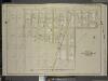
Brooklyn, Vol. 5, Double Page Plate No. 8; Part of Wards 29 & 32, Section 15; [Map bounded by Tilden Ave., Ralph Ave., Beverley Road (Avenue B); Including E. 57th St., Avenue D, E. 48th St.]
from Ward 29 and part of 32.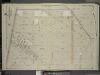
Brooklyn, Vol. 5, Double Page Plate No. 5; Part of Wards 29 & 32, Section 15; [Map bounded by East Ninty Eight St., Lenox Road; Including Remsen Ave., East New York Ave.]
from Ward 29 and part of 32.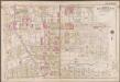
Plate 20: [Bounded by Regent Place, Tilden Avenue, (Holy Cross Cemetery) Canarsie Avenue, Canarsie Lane, E. 40th Street, Foster Avenue, E. 42nd Street, Farragut Road and Ocean Avenue.]; Atlas of the borough of Brooklyn, city of New York: from actual surveys and official plans by George W. and Walter S. Bromley.
from Atlas of the borough of Brooklyn, city of New York : from actual surveys and official plans by George W. and Walter S. Bromley. G.W. Bromley & Co.,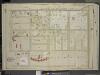
Brooklyn, Vol. 5, Double Page Plate No. 3; Part of Wards 29, Section 15; [Map bounded by East New York Ave., Utica Ave., Clarkson Ave.; Including Albany Ave., Winthrop St., Kingston Ave.]
from Ward 29 and part of 32.
Part of Ward 29. Land Map Sections, No. 5 & 15, Volume 2, Brooklyn Borough, New York City.
from Atlas of the Brooklyn borough of the City of New York : originally Kings Co.; complete in three volumes ... based upon official maps and plans ... / by and under the supervision of Hugo Ullitz, C.E.
Brooklyn, Vol. 5, Double Page Plate No. 6; Part of Wards 29 & 32, Section 15; [Map bounded by E. Ninety Eight St., Avenue B; Including Remsen Ave., Lenox Road]
from Ward 29 and part of 32.
Brooklyn, Vol. 5, Double Page Plate No. 11; Part of Ward 29, Section 15; [Map bounded by Tilden Ave. (Vernon Ave.), E. 48th St.; Including Avenue D, E. 37th St., Canarsie Ave.]
from Ward 29 and part of 32.
Plan of the city of Brooklyn, L.I. / by William Perris.
from Brooklyn
Plan of the city of Brooklyn, L.I. / by William Perris.
from Brooklyn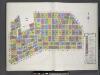
Key
From Atlas 92. Vol. 10, 1905.
Area Zoning Map Section No. 17
From Area zoning map of the city of New York, compiled in the Dept. of City Planning, Division of Mapping and Zoning, May 27, 1953. Irving F. Ashworth, senior civil engineer.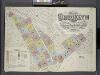
Insurance Maps of the Brooklyn city of New York Volume Seven. Published by the Sanborn map co. 117, Broadway, New York. 1888.
From Atlas 83. Vol. 7, 1888.
Community resources
From District 5
Spring Creek -- Linear City. (cont.)
From Spring Creek -- Linear City
Map of the city of Brooklyn, as laid out by commissioners, and confirmed by acts of the Legislature of the state of New York : made from actual surveys, the farm lines and names of original owners, being accurately drawn from authentic sources, contai...
From Brooklyn
East Astoria, part of Long Island City, Queens Co.
from Atlas of Long Island, New York. From recent and actual surveys and records.
![Brooklyn, Vol. 5, Double Page Plate No. 9; Part of Ward 29, Section 15; [Map bounded by E. 55th St., Tilden Ave. (Vernon Ave.); Including Schenectady Ave., Clarkson Ave.]](https://images-2.georeferencer.com/images/iiif/714264495587/full/,300/0/native.jpg)

