Maps of Kings County
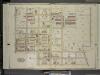
Brooklyn, Vol. 4, Double Page Plate No. 17; Part of Ward 26; Sections 13; [Map bounded by Hemlock St., Dumont Ave., New Lots Ave.; Including Milford St., Pitkin Ave., Fountain Ave., Liberty Ave.]
from Wards 26 and part of 29 & 32.
Part of Ward 26. Land Map Section, No. 13. Volume 1, Brooklyn Borough, New York City.
from Atlas of the Brooklyn borough of the City of New York : originally Kings Co.; complete in three volumes ... based upon official maps and plans ... / by and under the supervision of Hugo Ullitz, C.E.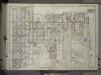
Brooklyn, Vol. 1, 2nd Part, Double Page Plate No. 45; Part of Wards 26, Section 13; [Map bounded by McKinley Ave. (Magenta St.), Autumn Ave., McKinley Ave., boundary line of the boroughs of Brooklyn and Queens, Dumont Ave., Crystal Ave.; Including New...
From Volume 1, part 2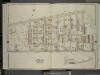
Brooklyn, Vol. 4, Double Page Plate No. 16; Part of Ward 26; Sections 13; [Map bounded by Atlantic Ave., Forbell Ave., Broadway; Including Liberty Ave., Fountain Ave.]; Sub Plan; [Map bounded by Magenta St., Boundary Line of the Borough of Bro
from Wards 26 and part of 29 & 32.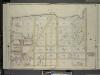
Brooklyn, Vol. 4, Double Page Plate No. 18; Part of Ward 26; Sections 13; [Map bounded by Boundary Line of the Borough of Brooklyn Ruby St. and Queens Spring Creek, Dumont Ave.; Including Hemlock St., Conduit Ave., Liberty Ave.]
from Wards 26 and part of 29 & 32.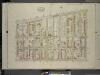
Brooklyn, Vol. 4, Double Page Plate No. 12; Part of Ward 26; Sections 13; [Map bounded by Atlantic Ave., Fountain Ave.; Including Pitkin Ave., Ashford St.]
from Wards 26 and part of 29 & 32.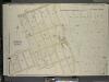
Brooklyn, Vol. 4, Double Page Plate No. 21; Part of Ward 26; Sections 14; [Map bounded by Newlots Ave., Fountain Ave., Dumont Ave., Hemlock St.; Including Old Mill Road, Wortman Ave., Stanley Ave., Berriman St.]; Sub Plan; [Map bounded by Stanley A
from Wards 26 and part of 29 & 32.
Plate 39: Part of Ward 26. Brooklyn, N.Y.
from Robinson's atlas of the city of Brooklyn, New York : embracing all territory within its corporate limits; from official records ... / by and under the supervision of E. Robinson and R.H. Pidgeon, civil engineers.
17B - N.Y. City (Aerial Set).
from Sectional aerial maps of the City of New York / [photographed and assembled under the direction of the chief engineer, July 1st, 1924].
Sec. 9 East New York.
1 : 6000 Fulton, Henry; J.B. Beers & Co.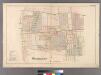
Woodhaven, Town of Jamaica.
from Atlas of Queens Co., Long Island, New York / compiled from official records, private plans & actual surveys by and under the direction of Chester Wolverton.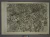
18A - N.Y. City (Aerial Set).
from Sectional aerial maps of the City of New York / [photographed and assembled under the direction of the chief engineer, July 1st, 1924].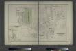
Woodhaven, Town of Jamaica, Queens Co. - South Woodhaven, Town of Jamaica, Queens Co.
from Atlas of Long Island, New York. From recent and actual surveys and records.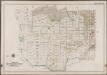
Plate 41: [Bounded by Linwood St., Cozine Ave., Shepherd Ave., Vienna Ave., Berriman St., Hegeman Ave., Milford St., Glenmore Ave., Ruby St., Belmont Ave., Drew Ave., Hegeman Ave., Saphire St., Vienna Ave., Amber St., Stanley Ave., Emerald St., Cozine Ave., Ruby Ave., Fairfield Ave. & Vandalia Ave.]; Atlas of the borough of Brooklyn, city of New York: from actual surveys and official plans by George W. and Walter S. Bromley.
from Atlas of the borough of Brooklyn, city of New York : from actual surveys and official plans by George W. and Walter S. Bromley. G.W. Bromley & Co.,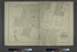
Portion of East New York. New Lots Tn. Kings Co. L.I. [Jamaica Plank Road to Liberty Avenue, Eldert Avenue to Eldert Lane.]
from Atlas of Long Island, New York. From recent and actual surveys and records.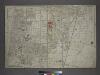
[Plate 31: Bounded by New York and Rockaway Beach, Ocean Avenue, Freeland Avenue, Flushing (Woodhaven) Avenue, Sutter Avenue, Cedar Lane, Conduit, Ruby Street, Atlantic Avenue, Drew Avenue, and (Crest Park) Brooklyn and Jamaica Plank Avenue.]
from Atlas of the city of New York, borough of Queens, Long Island City, Newtown, Flushing, Jamaica, Far Rockaway, from actual surveys and official plans / by George W. and Walter S. Bromley.
Portion of East New York. New Lots Tn. Kings Co. L.I. [Truxton Street to Bay Avenue, Hopkinson avenue to Butler Avenue.]
from Atlas of Long Island, New York. From recent and actual surveys and records.
Brooklyn, Vol. 1, 2nd Part, Double Page Plate No. 47; Part of Wards 26, Section 14; [Map bounded by Fountain Ave., Vandalia Ave., Barbey St.; Including Repose Pl., Schenk Ave., New Lots Ave.] / by and under the direction of Hugo Ullitz.
From Volume 1, part 2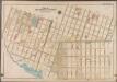
Plate 42: [Bounded by Riverdale Avenue, Hinsdale Street, Dumont Avenue, Vansiclen Avenue, Stanley Avenue, Louisiana Avenue, Warehouse Street, Williams Avenue, Vienna Avenue, Thatford Street, Hegeman Street & Rockaway Avenue.]; Atlas of the borough of Brooklyn, city of New York: from actual surveys and official plans by George W. and Walter S. Bromley.
from Atlas of the borough of Brooklyn, city of New York : from actual surveys and official plans by George W. and Walter S. Bromley. G.W. Bromley & Co.,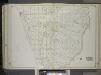
Brooklyn, Vol. 1, 2nd Part, Double Page Plate No. 46; Part of Wards 26, Section 14; [Map bounded by Dumont Ave., boundary line of the boroughs of Brooklyn and Queens, Vandalia Ave.; Including Crescent St., Fairfield Ave., Fountain Ave.] / by and under...
From Volume 1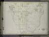
Brooklyn, Vol. 1, 2nd Part, Double Page Plate No. 46; Part of Wards 26, Section 14; [Map bounded by Dumont Ave., boundary line of the boroughs of Brooklyn and Queens, Vandalia Ave.; Including Crescent St., Fairfield Ave., Fountain Ave.] / by and under...
From Volume 1, part 2
Part of Ward 26. Land Map Section, No. 14. Volume 1, Brooklyn Borough, New York City.
from Atlas of the Brooklyn borough of the City of New York : originally Kings Co.; complete in three volumes ... based upon official maps and plans ... / by and under the supervision of Hugo Ullitz, C.E.
Part of Ward 26. Land Map Section, No. 14. Volume 1, Brooklyn Borough, New York City.
from Atlas of the Brooklyn borough of the City of New York : originally Kings Co.; complete in three volumes ... based upon official maps and plans ... / by and under the supervision of Hugo Ullitz, C.E.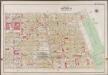
Plate 39: [Bounded by Barbey Street, (Highland Park) Sunnyside Avenue, Force Tube Avenue, Jamaica Turnpike, Logan Street and Sutter Street.]; Atlas of the borough of Brooklyn, city of New York: from actual surveys and official plans by George W. and Walter S. Bromley.
from Atlas of the borough of Brooklyn, city of New York : from actual surveys and official plans by George W. and Walter S. Bromley. G.W. Bromley & Co.,
Part of Ward 26. Land Map Section, No. 13. Volume 1, Brooklyn Borough, New York City.
from Atlas of the Brooklyn borough of the City of New York : originally Kings Co.; complete in three volumes ... based upon official maps and plans ... / by and under the supervision of Hugo Ullitz, C.E.
Double Page Plate No. 43: [Bounded by Pitkin Avenue, Berriman Street, New Lots Avenue and Williams Avenue.]
from Atlas of the Brooklyn borough of the City of New York : originally Kings Co.; complete in three volumes ... based upon official maps and plans ... / by and under the supervision of Hugo Ullitz, C.E.
Part of Ward 26. Land Map Sections, Nos. 12 & 13. Volume 1, Brooklyn Borough, New York City.
from Atlas of the Brooklyn borough of the City of New York : originally Kings Co.; complete in three volumes ... based upon official maps and plans ... / by and under the supervision of Hugo Ullitz, C.E.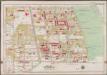
Plate 40: [Bounded by Logan Street, Jamaica Avenue (The Salem Fields Cemetery, Cypress Hills Cemetery, Maimonides Cem. Mt. Hope Cem.), Elderts Lane, Glen Street, Magenta Street, Drew Avenue & Glendorm Avenue.]; Atlas of the borough of Brooklyn, city of New York: from actual surveys and official plans by George W. and Walter S. Bromley.
from Atlas of the borough of Brooklyn, city of New York : from actual surveys and official plans by George W. and Walter S. Bromley. G.W. Bromley & Co.,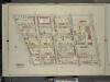
Brooklyn, Vol. 4, Double Page Plate No. 14; Part of Ward 26; Sections 13; [Map bounded by Euclid Ave., Atlantic Ave.; Including Hale Ave., Jamaica Ave.]
from Wards 26 and part of 29 & 32.
![Brooklyn, Vol. 4, Double Page Plate No. 17; Part of Ward 26; Sections 13; [Map bounded by Hemlock St., Dumont Ave., New Lots Ave.; Including Milford St., Pitkin Ave., Fountain Ave., Liberty Ave.]](https://images-2.georeferencer.com/images/iiif/517664236120/full/,300/0/native.jpg)

