Maps of Kings County
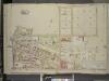
Brooklyn, Vol. 3, Double Page Plate No. 19; Part of Ward 18, Section 10; [Map bounded by Bennett St., Varick Ave., Maspeth Ave., Grand St., Bushwick Ave.; Including Old Woodpoint Rd., Skillman Ave., Kingland Ave.]
from Wards 13, 14, 15, 16, 17, 18, 19, 27 & 28.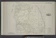
Vol. 2. Plate, D. [Map bound by Frost St., Kingsland Ave., Parker Pl., Vandervoort, Grant St., Bushwick Ave., Humboldt St.; Including Withers St., Jackson St., Skillman St., Benton St., Bullion St., Maspeth Ave., Orient Ave., Sharon St., Calhoun St., Dic
from Detailed estate and old farm line atlas of the city of Brooklyn : complete in six volumes ... from official records, private plans, and actual surveys ... / by G.M. Hopkins, C.E.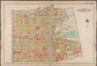
Plate 14: [Bounded by Bayard Street, Graham Avenue, Meeker Avenue, N. Henry Street, Herbert Street, Kingsland Avenue, Division Place, Morgan Avenue, Teneyck Street and Union Avenue.]; Atlas of the borough of Brooklyn, city of New York: from actual surveys and official plans by George W. and Walter S. Bromley.
from Atlas of the borough of Brooklyn, city of New York : from actual surveys and official plans by George W. and Walter S. Bromley. G.W. Bromley & Co.,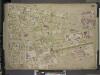
Brooklyn, Vol. 4, Double Page Plate No. 84; [Map bounded by Metropolitan Ave., Morgan Ave., Stagg St., Humbolt St., Devoe St., Bushwick Ave., Ten Eyck St., Judge St.; Including Powers St., Olive St., Catharine St., Grand St., Agate St.
from Insurance maps of the city of Brooklyn L.I.
Brooklyn V. 9, Plate No. 62 [Map bounded by Catherine St., Maujer St., Humboldt St., Devoe St.]
From Atlas 90. Vol. 9, 1907.
Part of Wards 16 & 18, Land Map Section, No. 10, Volume 1. Brooklyn Borough, New York City.
from Atlas of the Brooklyn borough of the City of New York : originally Kings Co.; complete in three volumes ... based upon official maps and plans ... / by and under the supervision of Hugo Ullitz, C.E.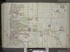
Brooklyn, Vol. 1, 2nd Part, Double Page Plate No. 36; Part of Wards 16 & 18, Section 10; [Map bounded by Richardson St. (Amos St.), Newtown Creek, Seneca Ave., Meserole Ave., Bushwick Ave.; Including Old Woodpoint Rd., Skillman Ave., Humboldt St., Ric...
From Volume 1
Plate 14: Part of Wards 15, 17 & 18. Brooklyn, N.Y.
from Robinson's atlas of the city of Brooklyn, New York : embracing all territory within its corporate limits; from official records ... / by and under the supervision of E. Robinson and R.H. Pidgeon, civil engineers.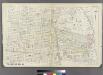
[Plate 27: Bounded by Withers Street, Kingsland Avenue, Parker Street, Vandervoort Avenue, Stagg Street, Morrill Street, Scholes Street and Union Avenue.]
from Atlas of the entire city of Brooklyn, complete in one volume. From actual surveys and official records by G. W. Bromley & Co.
Plate 16: Bounded by (Newtown Creek) Seneca Avenue, Flushing Avenue, Grattan Street, Knickerbocker Avenue, Morgan Avenue, Amos Street, Gardner Avenue, Maspeth Avenue, Scott Street and Bullion Street.
from Atlas of the city of Brooklyn, New York.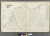
Plate 26: Part of Wards 17 & 18. City of Brooklyn.
from Atlas of the entire city of Brooklyn, complete in one volume. From actual surveys and official records by G. W. Bromley & Co.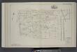
Vol. 2. Plate, F. [Map bound by Grand St., Canal, Meserole St., Old Bushwick Ave., Bushwick Ave.; Including Maujer St., Ten Eyck St., Meadow St., Stagg St., Scholes St., La Grange St., Waterbury St., Bogart St., Morgan Ave., Vandervoort Ave.]
from Detailed estate and old farm line atlas of the city of Brooklyn : complete in six volumes ... from official records, private plans, and actual surveys ... / by G.M. Hopkins, C.E.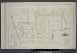
Vol. 2. Plate, E. [Map bound by Orient Ave., City Line, Meadow St., Canal, Vandervoort Ave.; Including Calhoun St., Dickinson St., Mill St., Grand St., Maujer St., Ten Eyck St., Porter Ave., Varick Ave., Metropolitan Ave., Stewart Ave., Gardner Ave., Sco
from Detailed estate and old farm line atlas of the city of Brooklyn : complete in six volumes ... from official records, private plans, and actual surveys ... / by G.M. Hopkins, C.E.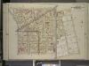
Brooklyn, Vol. 3, Double Page Plate No. 17; Part of Wards 15, 17 & 18, Sections 9 & 10; [Map bounded by Engert Ave. (Van Pelt Ave.), Morgan Ave.; Including Maspeth Ave., Skillman Ave., Manhattan Ave.]
from Wards 13, 14, 15, 16, 17, 18, 19, 27 & 28.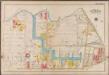
Plate 16: [Bounded by Newton Creek (Seneca Avenue), Grand Street, Gardner Avenue, Metropolitan Avenue, Scott Avenue, Meserole Street, Seneca Avenue, Purdy Place, Flushing Avenue, Knickerbocker Avenue, Morgan Avenue and Amos Street.]; Atlas of the borough of Brooklyn, city of New York: from actual surveys and official plans by George W. and Walter S. Bromley.
from Atlas of the borough of Brooklyn, city of New York : from actual surveys and official plans by George W. and Walter S. Bromley. G.W. Bromley & Co.,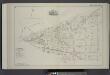
Vol. 2. Plate, A. [Map bound by Bayard (Sanford) St., Meeker Ave., Vandervoort Ave., Parker Pl., Kingsland Ave., Frost St., Humboldt Ave., Richardson St., Ewen St.; Including Herbert St., Anthony St., Lombard St., Beadel St., Division St., Amos St., Benn
from Detailed estate and old farm line atlas of the city of Brooklyn : complete in six volumes ... from official records, private plans, and actual surveys ... / by G.M. Hopkins, C.E.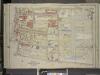
Brooklyn, Vol. 3, Double Page Plate No. 21; Part of Wards 16 & 18, Section 10; [Map bounded by Grand St., Varick Ave.; Including Johnson Ave., Bushwick Pl., Bushwick Ave.]
from Wards 13, 14, 15, 16, 17, 18, 19, 27 & 28.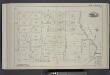
Vol. 2. Plate, C. [Map bound by Division Pl., Newtown Creek, Orient St., Vandervoort Ave.; Including Amos St., Bennett St., Parker St., Benton St., Bullion St., Maspeth St., Porter Ave., Varick Ave., Stewart Ave., Cardner Ave., Scott Ave., Seneca Ave.]
from Detailed estate and old farm line atlas of the city of Brooklyn : complete in six volumes ... from official records, private plans, and actual surveys ... / by G.M. Hopkins, C.E.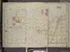
Brooklyn, Vol. 3, Double Page Plate No. 20; Part of Ward 18, Section 10; [Map bounded by Newtown Creek, Stagg St.; Including Varick Ave., Grand St., Bennett St.]
from Wards 13, 14, 15, 16, 17, 18, 19, 27 & 28.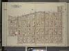
Brooklyn, Vol. 3, Double Page Plate No. 5; Part of Wards 15, 16 & 18, Sections 9 & 10; [Map bounded by Bushwick Ave., Bushwick PL., Montrose Ave., Leonard St.; Including Metropolitan Ave., Manhattan Ave., Skillman Ave., Old Woodpoint Rd., M
from Wards 13, 14, 15, 16, 17, 18, 19, 27 & 28.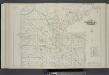
Vol. 6. Plate, H. [Map bound by Van Cott Ave., Van Pelt Ave., Monitor St., Meeker Ave., Richardson St., Humboldt St., Conselyea St., Union Ave.; Including Jane St., Newton St., Bayard St., Frost St., Withers St., Jackson St., Skillman St., Lorimer St., L
from Detailed estate and old farm line atlas of the city of Brooklyn : complete in six volumes ... from official records, private plans, and actual surveys ... / by G.M. Hopkins, C.E.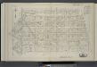
Vol. 6. Plate, I. [Map bound by Conselyea St., Bushwick Ave., Ten Eyck St., S. Second St., Eleventh St., Grand St., Tenth St., Union Ave.; Including N. Second St., Devoe St., Ainslie St., Hope St., Powers St., S. First St., Maujer St., Lorimer St., Leona
from Detailed estate and old farm line atlas of the city of Brooklyn : complete in six volumes ... from official records, private plans, and actual surveys ... / by G.M. Hopkins, C.E.
Brooklyn, Vol. 4, Double Page Plate No. 81; [Map bounded by Humboldt St., Herbert St., Meeker Ave., William St., North Henry St. (not opened), Richardson St., Humboldt St., Ainslie St., Leonard St.; Including Frost St., Withers St., Jackson St.
from Insurance maps of the city of Brooklyn L.I.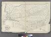
[Plate 30: Bounded by Seneca Avenue, Covert Street, Suydam Street, Cypress Avenue, Harman Street, St. Nicholas Avenue, Grove Street, Myrtle Avenue, Ralph Street, Knickerbocker Avenue, Bleecker Street, Hamburg Avenue, Harman Street, Central Avenue, Flushi
from Atlas of the entire city of Brooklyn, complete in one volume. From actual surveys and official records by G. W. Bromley & Co.
13A - N.Y. City (Aerial Set).
from Sectional aerial maps of the City of New York / [photographed and assembled under the direction of the chief engineer, July 1st, 1924].
Plan of the city of Brooklyn, L.I. / by William Perris.
from Brooklyn
Plan of the city of Brooklyn, L.I. / by William Perris.
from Brooklyn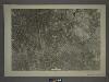
13C - N.Y. City (Aerial Set).
from Sectional aerial maps of the City of New York / [photographed and assembled under the direction of the chief engineer, July 1st, 1924].
A map of the village of Williamsburgh, Kings County, N.Y. : showing each lot of ground in said village, as laid down on the assessment of the village, together with the assessment number of each lot / made by Isaac [V]ieth, under the supervision of Henry
from Brooklyn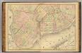
![Brooklyn, Vol. 3, Double Page Plate No. 19; Part of Ward 18, Section 10; [Map bounded by Bennett St., Varick Ave., Maspeth Ave., Grand St., Bushwick Ave.; Including Old Woodpoint Rd., Skillman Ave., Kingland Ave.]](https://images-2.georeferencer.com/images/iiif/150344320100/full/,300/0/native.jpg)

