Maps of Kings County
Brooklyn, Vol. 3, Double Page Plate No. 6; Part of Wards 13, 14, 15 & 16, Sections 8, 9 & 10; [Map bounded by Metropolitan Ave., Leonard St., Meserole St., S. Fourth St., Keap St., Broadway; Including Havemeyer St., S. Third St., Roebli
from Wards 13, 14, 15, 16, 17, 18, 19, 27 & 28.
Vol. 6. Plate, N. [Map bound by S. Sixth St., Broadway, Seventh St., Division Ave., S. Eleventh St., East River; Including S. Eighth St., S. Ninth St., S. Tenth St., First St., Second St., Third St., Fourth St., Fifth St., Sixth St.]
from Detailed estate and old farm line atlas of the city of Brooklyn : complete in six volumes ... from official records, private plans, and actual surveys ... / by G.M. Hopkins, C.E.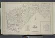
Vol. 6. Plate, T. [Map bound by First St., Second St., S.11th St., Third St., S.10th St., Fourth St., 5th St., 6th St., 7th St., 8th St., 9th St., Rodney St., Marcy Ave., Keap St., Lee Ave., Wilson St., Canal, East River; Including Division Ave., Rush St
from Detailed estate and old farm line atlas of the city of Brooklyn : complete in six volumes ... from official records, private plans, and actual surveys ... / by G.M. Hopkins, C.E.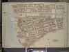
Brooklyn, Vol. 3, Double Page Plate No. 7; Part of Ward 13, Section 8; [Map bounded by South Third St., Haveneyer St.; Including Division Ave., East River]
from Wards 13, 14, 15, 16, 17, 18, 19, 27 & 28.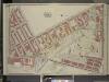
Brooklyn, Vol. 3, Double Page Plate No. 1; Part of Ward 19, Section 8; [Map bounded by Lee Ave., Taylor St., Wythe Ave., Franklin Ave., Flushing Ave., Washington Ave., Wallabout Channel, Division Ave.]
from Wards 13, 14, 15, 16, 17, 18, 19, 27 & 28.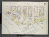
Brooklyn V. 3, Double Page Plate No. 61 [Map bounded by Division Ave., Wythe Ave., Ross St., East River]
From Atlas 69. Vol. 3, 1887.
Plate 9: Part of Wards 13, 16 & 19. Brooklyn, N.Y.
from Robinson's atlas of the city of Brooklyn, New York : embracing all territory within its corporate limits; from official records ... / by and under the supervision of E. Robinson and R.H. Pidgeon, civil engineers.
Plan of the U. S. Navy Yard, N. Y., showing improvements up to July 1, 1894.
From Brooklyn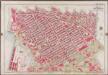
Plate 9: [Bounded by S. 11th Street, Berry Street, S. 10th Street, Bedford Avenue, S. Ninth Street, Roebling Street, Broadway, Marcy Avenue, S. Fifth Street, Rodney Street, S. Fourth Street, Keap Street, S. Third Street, Hooper Street, S. Second Street, Union Avenue, Broadway, Throop Avenue, Lorimer Street, Harrison Avenue, Flushing Avenue, Washington Avenue & and Kent Avenue.]; Atlas of the borough of Brooklyn, city of New York: from actual surveys and official plans by George W. and Walter S. Bromley.
from Atlas of the borough of Brooklyn, city of New York : from actual surveys and official plans by George W. and Walter S. Bromley. G.W. Bromley & Co.,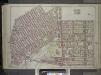
Brooklyn, Vol. 1, 2nd Part, Double Page Plate No. 29; Part of Wards 7 & 19, Section 7 & 8; [Map bounded by Marcy Ave., Heyward St., Lee Ave., Flushing Ave., Bedford Ave.; Including Willoughby Ave., Washington Ave., Cross St., Wallabout Channel, Divisi...
From Volume 1
Part of Wards 7 & 19. Land Map Sections, No. 7 & 8, Volume 1, Brooklyn Borough, New York City.
from Atlas of the Brooklyn borough of the City of New York : originally Kings Co.; complete in three volumes ... based upon official maps and plans ... / by and under the supervision of Hugo Ullitz, C.E.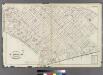
[Plate 20: Bounded by S. 11th Street, Division Avenue, Broadway, Heyward Street, Harrison Avenue, Middleton Street, Marcy Avenue, Flushing Avenue, Classon Avenue, Kent Avenue and 1st Street.]
from Atlas of the entire city of Brooklyn, complete in one volume. From actual surveys and official records by G. W. Bromley & Co.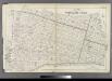
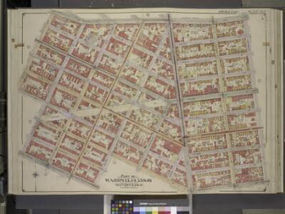
Plate 21: Part of Wards 13, 14, 15, 16 & 19 City of Brooklyn.
from Atlas of the entire city of Brooklyn, complete in one volume. From actual surveys and official records by G. W. Bromley & Co.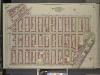
Brooklyn, Vol. 3, Double Page Plate No. 2; Part of Wards 13 & 19, Section 8; [Map bounded by Broadway, Roooney St., Marcy Ave., Lorimer St., Flushing Ave., Wallabout St., Wythe Ave., Taylor St., Lee Ave., Division Ave., Havemeyer St.]
from Wards 13, 14, 15, 16, 17, 18, 19, 27 & 28.
Plate 10: Bounded by N. Second Street, Kent Avenue, N. Third Street, Wythe Avenue, N. Fifth Street, Berry Street, N. Seventh Street, Bedford Avenue, N. Ninth Street, Driggs Street, N. 10th Street, Union Avenue, S. Second Street, Hooper Street, S. Third S
from Atlas of the city of Brooklyn, New York.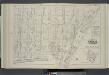
Vol. 6. Plate, S. [Map bound by Lee Ave., Flushing Ave., Classon Ave., Hewes St., Canal, Wilson St.; Including Bedford Ave., Wythe Ave., Kent Ave., Ross St., Rodney St., Keap St., Hooper St., Penn St., Rutledge St., Heyward St., Lynch St., Middleton St.,
from Detailed estate and old farm line atlas of the city of Brooklyn : complete in six volumes ... from official records, private plans, and actual surveys ... / by G.M. Hopkins, C.E.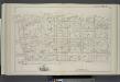
Vol. 6. Plate, M. [Map bound by Grand St., Seventh St., Broadway, S. Sixth St., East River; Including S. First St., S. Second St., S. Third St., S. Fourth St., S. Fifth St., River St., First St., Second St., Third St., Fourth St., Fifth St., Sixth St.]
from Detailed estate and old farm line atlas of the city of Brooklyn : complete in six volumes ... from official records, private plans, and actual surveys ... / by G.M. Hopkins, C.E.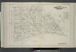
Vol. 6. Plate, O. [Map bound by Grand St., Eleventh St., S.2nd St., Union Ave., Broadway, Division Ave., Seventh St.; Including S.1St St., S.2nd St., S.3rd St., S.4th St., S.5th St., S.9th St., Seventh St., Eighth St., Ninth St., Tenth St., Eleventh St.,
from Detailed estate and old farm line atlas of the city of Brooklyn : complete in six volumes ... from official records, private plans, and actual surveys ... / by G.M. Hopkins, C.E.
[Plate 1: Map bounded by North 12th Street, 1st Street, North 5th Street, Wythe Street, North 3rd Street, 1st Street, South 7th Street, East River]
from Maps of the city of Brooklyn
[Plate 2: Map bounded by South 8th Street, 1st Street, Division Street, Devoe Street, Union Avenue, Ainslie Street, 1st Street, 9th Street, Smith Street, Messerole Street, Scholl Street, Waterbury Street, Remsen Street, Wyckoff Street]
from Maps of the city of Brooklyn
Brooklyn V. 3, Plate No. 29 [Map bounded by Hooper, Wythe Ave., Franklin Ave., Flushing Ave., Classon Ave., Wallabout PL.]
From Atlas 71. Vol. 3, 1918.
Map of the City of Williamsburg and town of Bushwick, inclu. Greenpoint with part of the City of Brooklyn
From Brooklyn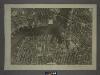
12D - N.Y. City (Aerial Set).
from Sectional aerial maps of the City of New York / [photographed and assembled under the direction of the chief engineer, July 1st, 1924].
A map of the village of Williamsburgh, Kings County, N.Y. : showing each lot of ground in said village, as laid down on the assessment of the village, together with the assessment number of each lot / made by Isaac [V]ieth, under the supervision of Henry
from Brooklyn
Plan of the city of Brooklyn, L.I. / by William Perris.
from Brooklyn
Part of Wards 13 & 14. Land Map Section, No. 8, Volume 1, Brooklyn Borough, New York City.
from Atlas of the Brooklyn borough of the City of New York : originally Kings Co.; complete in three volumes ... based upon official maps and plans ... / by and under the supervision of Hugo Ullitz, C.E.
Sec. 1. Brooklyn map.
1 : 6000 Fulton, Henry; J.B. Beers & Co.
Brooklyn, Vol. 3, Double Page Plate No. 8; Part of Wards 13 & 14, Section 8; [Map bounded by North Fifth St., Roebling St.; Including South Third St., East River]
from Wards 13, 14, 15, 16, 17, 18, 19, 27 & 28.
Double Page Plate No. 32: [Bounded by Marcy Ave., Metropolitan Ave., N. Fifth St., Havemeyer St., Withers St., Union Ave., Richardson St., Leonard St., Frost St., Manhattan Ave., Withers St., Graham Ave., Jackson St., Humboldt St., Metropolitan Ave., Bus
from Atlas of the Brooklyn borough of the City of New York : originally Kings Co.; complete in three volumes ... based upon official maps and plans ... / by and under the supervision of Hugo Ullitz, C.E.