Maps of Kings County

Brooklyn, Vol. 2, Double Page Plate No. 5; Part of Wards 7 & 20, Section 7; [Map bounded by Kent Ave., Be Kalb Ave.; Including Waverly Ave., Flushing Ave.]
from Wards 7, 11, 20, 21, 23, 24 & 25.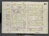
Brooklyn V. 3, Double Page Plate No. 64 [Map bounded by Bedford Ave., Myrtle Ave., Classon Ave., Wallabout St.]
From Atlas 69. Vol. 3, 1887.
[Plate 36: Maps Covering Various Areas]
from Maps of the city of Brooklyn
Brooklyn V. 3, Plate No. 29 [Map bounded by Hooper, Wythe Ave., Franklin Ave., Flushing Ave., Classon Ave., Wallabout PL.]
From Atlas 71. Vol. 3, 1918.
Plate 7: Bounded by Flushing Avenue, Nostrand Avenue, De Kalb Avenue and Clinton Avenue.
from Atlas of the entire city of Brooklyn, complete in one volume. From actual surveys and official records by G. W. Bromley & Co.
Plate 8: Bounded by Flushing Wallabout Avenue, Nostrand Avenue, Lafayette Avenue and Clermont Avenue.
from Atlas of the city of Brooklyn, New York.
Brooklyn, Vol. 1, 2nd Part, Double Page Plate No. 29; Part of Wards 7 & 19, Section 7 & 8; [Map bounded by Marcy Ave., Heyward St., Lee Ave., Flushing Ave., Bedford Ave.; Including Willoughby Ave., Washington Ave., Cross St., Wallabout Channel, Divisi...
From Volume 1
Part of Wards 7 & 19. Land Map Sections, No. 7 & 8, Volume 1, Brooklyn Borough, New York City.
from Atlas of the Brooklyn borough of the City of New York : originally Kings Co.; complete in three volumes ... based upon official maps and plans ... / by and under the supervision of Hugo Ullitz, C.E.
Plate 8: [Bounded by Flushing Avenue, Nostrand Avenue, Lafayette Avenue and Cromwell Avenue.]; Atlas of the borough of Brooklyn, city of New York: from actual surveys and official plans by George W. and Walter S. Bromley.
from Atlas of the borough of Brooklyn, city of New York : from actual surveys and official plans by George W. and Walter S. Bromley. G.W. Bromley & Co.,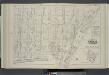
Vol. 6. Plate, S. [Map bound by Lee Ave., Flushing Ave., Classon Ave., Hewes St., Canal, Wilson St.; Including Bedford Ave., Wythe Ave., Kent Ave., Ross St., Rodney St., Keap St., Hooper St., Penn St., Rutledge St., Heyward St., Lynch St., Middleton St.,
from Detailed estate and old farm line atlas of the city of Brooklyn : complete in six volumes ... from official records, private plans, and actual surveys ... / by G.M. Hopkins, C.E.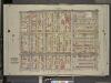
Brooklyn, Vol. 2, Double Page Plate No. 10; Part of Wards 7 & 21, Sections 6 & 7; [Map bounded by Flushing Ave., Marcy Ave.; Including Willoughby Ave., Kent Ave.]
from Wards 7, 11, 20, 21, 23, 24 & 25.
Brooklyn, Vol. 2, Double Page Plate No. 4; Part of Wards 20 & 11, Section 7; [Map bounded by Waverly Ave., De Kalb Ave.; Including North Elliott PL., Flushing Ave.]
from Wards 7, 11, 20, 21, 23, 24 & 25.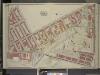
Brooklyn, Vol. 3, Double Page Plate No. 1; Part of Ward 19, Section 8; [Map bounded by Lee Ave., Taylor St., Wythe Ave., Franklin Ave., Flushing Ave., Washington Ave., Wallabout Channel, Division Ave.]
from Wards 13, 14, 15, 16, 17, 18, 19, 27 & 28.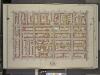
Brooklyn, Vol. 2, Double Page Plate No. 6; Part of Ward 7, Section 7; [Map bounded by De Kalb Ave., Bedford Ave.; Including Gates Ave., Washington Ave.]
from Wards 7, 11, 20, 21, 23, 24 & 25.
[Plate 22: Map bounded by Myrtle Avenue, Clinton Street, Lafayette Avenue, Cumberland Street]
from Maps of the city of Brooklyn
[Plate 21: Map bounded by Flushing Avenue, Clinton Avenue, Myrtle Avenue, Cumberland Street]
from Maps of the city of Brooklyn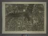
12D - N.Y. City (Aerial Set).
from Sectional aerial maps of the City of New York / [photographed and assembled under the direction of the chief engineer, July 1st, 1924].
Plan of the city of Brooklyn, L.I. / by William Perris.
from Brooklyn
A map of the village of Williamsburgh, Kings County, N.Y. : showing each lot of ground in said village, as laid down on the assessment of the village, together with the assessment number of each lot / made by Isaac [V]ieth, under the supervision of Henry
from Brooklyn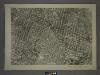
16B - N.Y. City (Aerial Set).
from Sectional aerial maps of the City of New York / [photographed and assembled under the direction of the chief engineer, July 1st, 1924].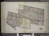
Brooklyn, Vol. 1, Double Page Plate No. 28; Part of Wards 11 & 20, Section 7; Map bounded by Flushing Ave., Washington Ave., Willoughby Ave., Washington Park; Including De Kalb Ave., Hudson Ave., Fulton St., Johnson St., Navy St. / by and under the di...
From Volume 1
Part of Wards 11 & 20. Land Map Section, No. 7, Volume 1, Brooklyn Borough, New York City.
from Atlas of the Brooklyn borough of the City of New York : originally Kings Co.; complete in three volumes ... based upon official maps and plans ... / by and under the supervision of Hugo Ullitz, C.E.
Plan of the U. S. Navy Yard, N. Y., showing improvements up to July 1, 1894.
From Brooklyn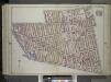
Brooklyn, Vol. 1, Double Page Plate No. 27; Part of Wards 7-11, 20 Section 7; [Map bounded by Willoughby Ave., Steuben St., Lafayette Ave., Grand Ave., Atlantic Ave.; Including Flatbush Ave., Fulton St., Hudson Ave., De Kalb Ave., Washington Park] / b...
From Volume 1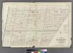
Plate 6: Part of Wards 11 & 20 City of Brooklyn.
from Atlas of the entire city of Brooklyn, complete in one volume. From actual surveys and official records by G. W. Bromley & Co.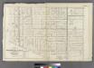
Plate 8: Part of Wards 7, 20, 21& 23. City of Brooklyn.
from Atlas of the entire city of Brooklyn, complete in one volume. From actual surveys and official records by G. W. Bromley & Co.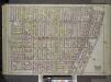
Brooklyn, Vol. 1, Double Page Plate No. 26; Part of Wards 7, 21 & 23, Sections 6 & 7; [Map bounded by Marcy Ave., Fulton St., New York Ave., Atlantic Ave.; Including Grand Ave., Lafayette Ave., Steuben St., Willoughby Ave.] / by and under the directio...
From Volume 1
Double Page Plate No. 27: [Bounded by Willoughby Avenue, Steuben Street, Lafayette Avenue, Grand Avenue, Atlantic Ave (Jamaica Turnpike), Flatbush Avenue, Fulton Street, (Fort Green) Dekalb Avenue and Washington Park.
from Atlas of the Brooklyn borough of the City of New York : originally Kings Co.; complete in three volumes ... based upon official maps and plans ... / by and under the supervision of Hugo Ullitz, C.E.
Plate 9: Part of Wards 13, 16 & 19. Brooklyn, N.Y.
from Robinson's atlas of the city of Brooklyn, New York : embracing all territory within its corporate limits; from official records ... / by and under the supervision of E. Robinson and R.H. Pidgeon, civil engineers.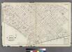
![Brooklyn, Vol. 2, Double Page Plate No. 5; Part of Wards 7 & 20, Section 7; [Map bounded by Kent Ave., Be Kalb Ave.; Including Waverly Ave., Flushing Ave.]](https://images-2.georeferencer.com/images/iiif/022533695855/full/,300/0/native.jpg)

