Maps of Hudson County
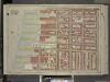
Brooklyn, Vol. 1, Double Page Plate No. 5; Part of Ward 6, Section 2; [Map bounded by Atlantic Ave., Clinton St., Degraw St., Sedgwick St., Van Brunt St.; Including Baltic St., Warren St., Congress St., Amity St., Pacific St.]
from Wards 1, 2, 3, 4, 5, 6, 8, 9, 10, 12 & 22.
Vol. 5. Plate, H. [Map bound by Atlantic Ave., Clinton St., Harrison St., East River; Including Pacific St., Amity St., Congress St., Verandan Pl., Warren St., Baltic St., Columbia St., Hicks St., Henry St.]
from Detailed estate and old farm line atlas of the city of Brooklyn : complete in six volumes ... from official records, private plans, and actual surveys ... / by G.M. Hopkins, C.E.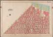
Plate 3: [Bounded by Van Brunt Street (East River Piers), Harrison Street, Columbia Street, Amity Street, Court Street, and Hamilton Avenue.]; Atlas of the borough of Brooklyn, city of New York: from actual surveys and official plans by George W. and Walter S. Bromley.
from Atlas of the borough of Brooklyn, city of New York : from actual surveys and official plans by George W. and Walter S. Bromley. G.W. Bromley & Co.,
Vol. 5. Plate, K. [Map bound by Harrison St., Henry St., Carroll St., Hamilton Ave., East River; Including Irving St., Sedgwick St., Degraw St., Sackett St., Union St., President St., Beach Pl., Van Brunt St., Columbia St., Tiffany Pl., Hicks St., Cheeve
from Detailed estate and old farm line atlas of the city of Brooklyn : complete in six volumes ... from official records, private plans, and actual surveys ... / by G.M. Hopkins, C.E.
[Plate 8: Map bounded by Pacific Street, Henry Street, Degraw Street, Van Brunt Street, Buttermilk Channel]
from Maps of the city of Brooklyn
[Plate 9: Map bounded by Buttermilk Channel, Van Brunt Street, Degraw Street, Columbia Street, Carroll Street, Hamilton Avenue]
from Maps of the city of Brooklyn
[Plate 17: Map bounded by Atlantic Street, Court Street, Degraw Street, Henry Street]
from Maps of the city of Brooklyn
Brooklyn Plate No. 8 [Map bounded by Van Brunt St., Harrison St., Columbia St., Union St.]
From Atlas 64. Vol. 1, 1904.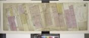
Double Page Plate No. 6; [Map bounded by Atlantic St., Columbia St., Pacific St., Amity St., Congress St.; Including Waren St., Baltic St., Harrison St., Van Brunt St.]
from Insurance maps of the warehouses, &c., in Brooklyn from the Navy yard to Partition Street.
[Plate 7: Map bounded by Pierrepont Street, Henry Street, Pacific Street, Buttermilk Channel]
from Maps of the city of Brooklyn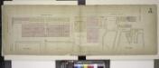
Double Page Plate No. 5; [Map boounded by Montague St. (Raised), Furman St., Atlantic St.; Including East River, Joralemon St., Ferry To Wall St. New York]
from Insurance maps of the warehouses, &c., in Brooklyn from the Navy yard to Partition Street.
Plate 2: Part of Wards 6 & 12. Brooklyn, N.Y.
from Atlas of the city of Brooklyn, New York.
Part of Wards 1,3,4,6 &10. Land Map Sections, No.1&2, Volume 1, Brooklyn Borough, New York City.
from Atlas of the Brooklyn borough of the City of New York : originally Kings Co.; complete in three volumes ... based upon official maps and plans ... / by and under the supervision of Hugo Ullitz, C.E.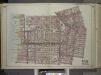
Brooklyn, Vol. 1, Double Page Plate No. 2; Part of Wards 1, 3, 4 & 6, Section 1 & 2; [Map bounded by Pierrepont St., Johnson St., Bridge St., Hoyt St., Smith St.; Including Warren St., Baltic St., East River, Furman St.] / by and under the direction o...
From Volume 1
Plate 15: Part of Wards 6, 10, & 12. City of Brooklyn.
from Atlas of the entire city of Brooklyn, complete in one volume. From actual surveys and official records by G. W. Bromley & Co.
Part of Wards 6,10 & 12. Land Map Section, No. 2, Volume 1, Brooklyn Borough, New York City.
from Atlas of the Brooklyn borough of the City of New York : originally Kings Co.; complete in three volumes ... based upon official maps and plans ... / by and under the supervision of Hugo Ullitz, C.E.
Plate 2: Bounded by Clark Street, Fulton Street, Tillary Street, Gold Street, Fulton Street, Bond Street, Atlantic Avenue, Court Street,Amity Street, Columbia Street, Atlantic Avenue and (East River Piers), Furman Street.
from Robinson's atlas of the city of Brooklyn, New York : embracing all territory within its corporate limits; from official records ... / by and under the supervision of E. Robinson and R.H. Pidgeon, civil engineers.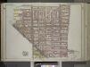
Brooklyn, Vol. 1, Double Page Plate No. 4; Part of Wards 6, 10 & 12, Section 2; [Map bounded by Baltic St., Warren St., Smith St., 5th St., Gowanus Canal; Including 7th St., Nelson St., Columbia St., Hamilton Ave.] / by and under the direction of Hugo...
From Volume 1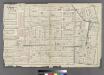
Plate 3: Part of Wards 1, 3, 4, & 6. City of Brooklyn.
from Atlas of the entire city of Brooklyn, complete in one volume. From actual surveys and official records by G. W. Bromley & Co.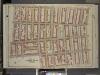
Brooklyn, Vol. 1, Double Page Plate No. 7; Part of Wards 6 & 10, Section 2; [Map bounded by Hoyt St., 4th St., 3rd PL., Hemry St.; Including Degraw St., Clinton St., Warren St.]
from Wards 1, 2, 3, 4, 5, 6, 8, 9, 10, 12 & 22.
Vol. 5. Plate, E. [Map bound by Pierrepont St., Fulton St., Court St., Atlantic Ave., East River; Including Montague St., Remsen St., Grace Court, Joralemon St., Livingston St., Schermerhorn St., State St., Furman St., Pierrepont Ter., Montague Ter., Col
from Detailed estate and old farm line atlas of the city of Brooklyn : complete in six volumes ... from official records, private plans, and actual surveys ... / by G.M. Hopkins, C.E.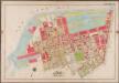
Plate 30:[Bounded by (New York Bay Piers) Ferris Street, Pioneer Street, (Atlantic Basin) Imlay Street, Hamilton Avenue, Hicks Street, Centre Street, Columbia Street, Bush Street, Otswego Street, Wolcott Street, Dwight Street, Beard Street, (Erie Basin) Van Brunt Street, Reid Street and Van Dyke Street.]; Atlas of the borough of Brooklyn, city of New York: from actual surveys and official plans by George W. and Walter S. Bromley.
from Atlas of the borough of Brooklyn, city of New York : from actual surveys and official plans by George W. and Walter S. Bromley. G.W. Bromley & Co.,
Brooklyn, Vol. 1, Double Page Plate No. 8; Part of Wards 6 & 12, Section 2; [Map bounded by Degraw St., Henry St., Coles St., Seabring St., Van Brunt St., Commerce St.; Including Commercial Wharf Conover St., India Wharf, Hamilton Ave., Un
from Wards 1, 2, 3, 4, 5, 6, 8, 9, 10, 12 & 22.
ol. 5. Plate, I. [Map bound by Atlantic St., State St., Bond St., Butler St., Court St., Harrison St., Clinton St.; Including Pacific St., Dean St., Bergen St., Wyckoff St., Warren St., Baltic St., Boerum St., Smith St., Hoyt St.]"
from Detailed estate and old farm line atlas of the city of Brooklyn : complete in six volumes ... from official records, private plans, and actual surveys ... / by G.M. Hopkins, C.E.
Vol. 5. Plate, L. [Map bound by Harrison St., Court St., Butler St., Hoyt St., Carroll St., Smith St., Henry St.; Including Degraw St., Sackett St., Union St., President St., Clinton St., Tompkins St.]
from Detailed estate and old farm line atlas of the city of Brooklyn : complete in six volumes ... from official records, private plans, and actual surveys ... / by G.M. Hopkins, C.E.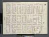
Brooklyn, V. 1, Double Page Plate No. 15 [Map bounded by Clinton St., Harrison St., Columbia St., State St.]
From Atlas 63. Vol. 1, 1886.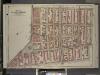
Brooklyn, Vol. 1, Double Page Plate No. 6; Part of Wards 1, 3, 6 & 10, Sections 1 & 2; [Map bounded by Hoyt St., Warren St.; Including Clinton St., Fulton St.]
from Wards 1, 2, 3, 4, 5, 6, 8, 9, 10, 12 & 22.
Vol. 5. Plate, N. [Map bound by Hamilton Ave., Carroll St., Columbia St., Verona St., East River; Including India St., Atlantic Basin, Summit St., Rapelyea St., Woodhull St., Bowne St., Seabring St., Commerce St., Delevan St., North Pier, South Pier, Com
from Detailed estate and old farm line atlas of the city of Brooklyn : complete in six volumes ... from official records, private plans, and actual surveys ... / by G.M. Hopkins, C.E.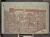
Brooklyn, Vol. 1, Double Page Plate No. 4; Part of Wards 1, Section 1; [Map bounded by Atlantic Ave., Furman St., Columbia Heights; Including Cranberry St., Fulton St., Clinton St.]
from Wards 1, 2, 3, 4, 5, 6, 8, 9, 10, 12 & 22.
![Brooklyn, Vol. 1, Double Page Plate No. 5; Part of Ward 6, Section 2; [Map bounded by Atlantic Ave., Clinton St., Degraw St., Sedgwick St., Van Brunt St.; Including Baltic St., Warren St., Congress St., Amity St., Pacific St.]](https://images-2.georeferencer.com/images/iiif/667160708587/full/,300/0/native.jpg)

