Maps of Hudson County

Brooklyn, Section 3; [Including Wards 12, 22]
from Farm line map of the city of Brooklyn, from official records and surveys; comp. and drawn by Henry Fulton.
Sheet 5: Map encompassing Red Hook, Cobble Hill, Carroll Gardens and Gowanus Canal.
from Map of the city of Brooklyn : being the former cities of Brooklyn & Williamsburgh and the town of Bushwick, as consolidated January 1st, 1855 by an act of the legislature of the State of New York ... showing also a part of the City of New York.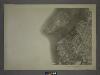
16A - N.Y. City (Aerial Set).
from Sectional aerial maps of the City of New York / [photographed and assembled under the direction of the chief engineer, July 1st, 1924].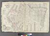
Plate 16: Part of Wards 6 & 12. City of Brooklyn.
from Atlas of the entire city of Brooklyn, complete in one volume. From actual surveys and official records by G. W. Bromley & Co.
Plan of the city of Brooklyn, L.I. / by William Perris.
from Brooklyn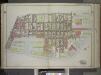
Brooklyn, Vol. 1, Double Page Plate No. 6; Part of Ward 12, Section 2; Map bounded by Dwight St., Erie Basin, Upper Bay; Including Buttermilk Channel, Hamilton Ave., Columbia St. / by and under the direction of Hugo Ullitz.
From Volume 1
Sec. 3. Brooklyn map.
1 : 6000 Fulton, Henry; J.B. Beers & Co.
Part of Ward 12. Land Map Section, No. 2, Volume 1, Brooklyn Borough, New York City.
from Atlas of the Brooklyn borough of the City of New York : originally Kings Co.; complete in three volumes ... based upon official maps and plans ... / by and under the supervision of Hugo Ullitz, C.E.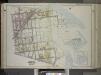
Brooklyn, Vol. 1, Double Page Plate No. 5; Part of Ward 12, Section 2; [Map bounded by Gowanus Canal, Henry St. Slip, Halleck St., Erie Basin; Including Beard St., Dwight St., Nelson St., 7th St.]; Sub Plan no. 1 [Map bounded by Henry St., Gowanus Can...
From Volume 1
Plate 30: Part of Ward 12. Brooklyn, N.Y.
from Robinson's atlas of the city of Brooklyn, New York : embracing all territory within its corporate limits; from official records ... / by and under the supervision of E. Robinson and R.H. Pidgeon, civil engineers.
Plate 31: Bounded by Richards Street, Partition Street, Dwight Street, Bush Street, Columbia Street, Centre Street, Hicks Street, Luquer Street, Henry Street, Nelson Street, Hamilton Avenue, Smith Street, Percival Street, Court Street, Bryant Street, Cli
from Robinson's atlas of the city of Brooklyn, New York : embracing all territory within its corporate limits; from official records ... / by and under the supervision of E. Robinson and R.H. Pidgeon, civil engineers.
Part of Ward 12. Land Map Section, No. 2, Volume 1, Brooklyn Borough, New York City.
from Atlas of the Brooklyn borough of the City of New York : originally Kings Co.; complete in three volumes ... based upon official maps and plans ... / by and under the supervision of Hugo Ullitz, C.E.
Part of Wards 6,10 & 12. Land Map Section, No. 2, Volume 1, Brooklyn Borough, New York City.
from Atlas of the Brooklyn borough of the City of New York : originally Kings Co.; complete in three volumes ... based upon official maps and plans ... / by and under the supervision of Hugo Ullitz, C.E.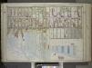
Brooklyn, Vol. 1, Double Page Plate No. 7; Part of Ward 8, Section 3; [Map bounded by 5th Ave., 37th St., The Narrows; Including Gowanus Canal, Prospect Ave.] / by and under the direction of Hugo Ullitz.
From Volume 1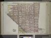
Brooklyn, Vol. 1, Double Page Plate No. 4; Part of Wards 6, 10 & 12, Section 2; [Map bounded by Baltic St., Warren St., Smith St., 5th St., Gowanus Canal; Including 7th St., Nelson St., Columbia St., Hamilton Ave.] / by and under the direction of Hugo...
From Volume 1
Part of Ward 8. Land Map Section, No. 3, Volume 1, Brooklyn Borough, New York City.
from Atlas of the Brooklyn borough of the City of New York : originally Kings Co.; complete in three volumes ... based upon official maps and plans ... / by and under the supervision of Hugo Ullitz, C.E.
Plan for the drainage of that part of the city of Brooklyn which empties its water into Gowanus Creek & Bay / by Daniel Richards, Oct. 1848 ; Willard Day, city surveyor.
from Brooklyn
Vol. 5. Plate, T. [Map bound by Henry St. Slip, Gowanus Bay Channel, Erie Basin, Halleck St., Henry St., Bay St.; Including Hicks St. Slip, Pond Slip, Otsego St.]
from Detailed estate and old farm line atlas of the city of Brooklyn : complete in six volumes ... from official records, private plans, and actual surveys ... / by G.M. Hopkins, C.E.
Plate 2: Part of Wards 6 & 12. Brooklyn, N.Y.
from Atlas of the city of Brooklyn, New York.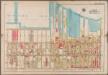
Plate 32: [Bounded by (New York Bay) Second Avenue, 28th Street, Third Avenue, Hamilton Avenue, Prospect Avenue, Fifth Avenue and 38th Street.]; Atlas of the borough of Brooklyn, city of New York: from actual surveys and official plans by George W. and Walter S. Bromley.
from Atlas of the borough of Brooklyn, city of New York : from actual surveys and official plans by George W. and Walter S. Bromley. G.W. Bromley & Co.,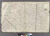
Plate 15: Part of Wards 6, 10, & 12. City of Brooklyn.
from Atlas of the entire city of Brooklyn, complete in one volume. From actual surveys and official records by G. W. Bromley & Co.
Brooklyn, Vol. 1, Double Page Plate No. 29; Part of Ward 8, Section 3; [Map bounded by 3rd Ave., 36th St.; Including 2nd Ave., Gowanus Canal]
from Wards 1, 2, 3, 4, 5, 6, 8, 9, 10, 12 & 22.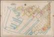
Plate 31: [Bounded by Richards Street, (Erie Basin Dry Docks) Beard Street, Dwight Street, Bush Street, Columbia Street, Center Street, Hicks Street, Hamilton Avenue, (Gowanus Canal) Smith Street, Percival Street, Court Street, Bryant Street, Clinton Street, (Henry Street Skip, Hicks Street Slip) Bay Street, Hicks Street, (Erie Basin) Halleck Street and Beard Street.]; Atlas of the borough of Brooklyn, city of New York: from actual surveys and official plans by George W. and Walter S. Bromley.
from Atlas of the borough of Brooklyn, city of New York : from actual surveys and official plans by George W. and Walter S. Bromley. G.W. Bromley & Co.,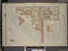
Brooklyn, Vol. 1, Double Page Plate No. 11; Part of Ward 12, Section 2; [Map bounded by Dikeman St., Dwight St.; Including Eire Basin, Upper Bay]
from Wards 1, 2, 3, 4, 5, 6, 8, 9, 10, 12 & 22.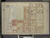
Brooklyn, Vol. 1, Double Page Plate No. 9; Part of Ward 12, Section 2; [Map bounded by Commerce St., Seabring St., Columbia St., Dwight St., Dkeman St.; Including Wolcott St., Sullivan St., King St., Clinton Wharf, Commerce St.]
from Wards 1, 2, 3, 4, 5, 6, 8, 9, 10, 12 & 22.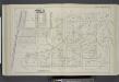
Vol. 5. Plate, Q. [Map bound by Atlantic Basin, Verona St., Columbia St., Otsego St., Partition St., Buttermilk Channel; Including Tremont St., Clinton Wharf, William St., King St., Sullivan St., Bush St., Wolcott St., Dikeman St., South Piers, Ferris St
from Detailed estate and old farm line atlas of the city of Brooklyn : complete in six volumes ... from official records, private plans, and actual surveys ... / by G.M. Hopkins, C.E.
Plan for the drainage of that part of the city of Brooklyn which empties its water into Gowanus Creek & Bay / by Daniel Richards, Oct. 1848 ; Willard Day, city surveyor.
From Brooklyn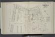
Vol. 5. Plate, N. [Map bound by Hamilton Ave., Carroll St., Columbia St., Verona St., East River; Including India St., Atlantic Basin, Summit St., Rapelyea St., Woodhull St., Bowne St., Seabring St., Commerce St., Delevan St., North Pier, South Pier, Com
from Detailed estate and old farm line atlas of the city of Brooklyn : complete in six volumes ... from official records, private plans, and actual surveys ... / by G.M. Hopkins, C.E.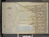
Brooklyn, Vol. 1, Double Page plate No. 28; Part of Wards 8 & 22, Sections 3&4; [Map bounded by Hamilton Ave., 15th St., 4th Ave.; Including 23rd St., Gowanus Canal]
from Wards 1, 2, 3, 4, 5, 6, 8, 9, 10, 12 & 22.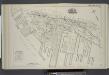
![Brooklyn, Section 3; [Including Wards 12, 22]](https://images-2.georeferencer.com/images/iiif/409634516502/full/,300/0/native.jpg)

