Maps of Kings County
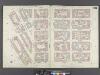
Brooklyn, Vol. 4, Double Page Plate No. 78; [Map bounded by Roebling St. late South St., South 3rd St., South 2nd St., South 1st St., Grand St., North 1st St.; Including North 2nd St., North 3rd St., North 4th St., North 5th St., North 6th St.,
from Insurance maps of the city of Brooklyn L.I.
Vol. 6. Plate, L. [Map bound by N.6th St., Sixth St., Grand St., East River; Including N.5th St., N.4th St., N.3rd St., N.2nd St., Fillmore Pl., N.1St St., First St., Second St., Third St., Fourth St., Fifth St.]
from Detailed estate and old farm line atlas of the city of Brooklyn : complete in six volumes ... from official records, private plans, and actual surveys ... / by G.M. Hopkins, C.E.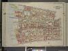
Brooklyn, Vol. 3, Double Page Plate No. 8; Part of Wards 13 & 14, Section 8; [Map bounded by North Fifth St., Roebling St.; Including South Third St., East River]
from Wards 13, 14, 15, 16, 17, 18, 19, 27 & 28.
[Map bounded by Corlears St, Mangin St, Stanton St, Pier - Line 55-62, Cherry St; Including Tompkins St, East St, Grand St, Broome St, Delancy Slip, Rivington St]
from Maps of the wharves & piers from the Battery to 61st street on the Hudson river and from the Battery to 41st street on the East river, New York. Surveyed by I.C. Buckhout, city surveyor.
Vol. 6. Plate, M. [Map bound by Grand St., Seventh St., Broadway, S. Sixth St., East River; Including S. First St., S. Second St., S. Third St., S. Fourth St., S. Fifth St., River St., First St., Second St., Third St., Fourth St., Fifth St., Sixth St.]
from Detailed estate and old farm line atlas of the city of Brooklyn : complete in six volumes ... from official records, private plans, and actual surveys ... / by G.M. Hopkins, C.E.
Plate 10: [Bounded by Metropolitan Ave., Kent Ave., N. Third St., Wythe Ave., N. Fifth St., Berry St., N. Seventh St., Bedford Ave., N. Ninth St., Driggs Ave., N. 10th St., Roebling St., Union Ave., S. Second St., Hooper St., S. Third St., Keap St., S. Fourth St., Rodney St., S. 5th St., Marcy Ave., Broadway, S. Roebling St., S. Ninth St., Bedford Ave., S. Tenth St., Berry St., S. 11th St., Kent Ave. & River St.]; Atlas of the borough of Brooklyn, city of New York: from actual surveys and official plans by George W. and Walter S. Bromley.
from Atlas of the borough of Brooklyn, city of New York : from actual surveys and official plans by George W. and Walter S. Bromley. G.W. Bromley & Co.,
Part of Section 2 : Plate 15.
from Atlas of the borough of Manhattan, city of New York.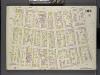
Brooklyn V. 4, Double Page Plate No.103 [Map bounded by Driggs St., S. 3rd St., Wythe Ave., N. 5th St.]
From Atlas 74. Vol. 4, 1887.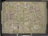
Brooklyn, Vol. 4, Double Page Plate No. 66; [Map bounded by 3rd St., South 1st St., East River, River St., Kent Ave., Including North 6th St., North 5th St., North 4th St., North 3rd St., North 2nd St., North 1st St., Grand St., Wythe Ave.]
from Insurance maps of the city of Brooklyn L.I.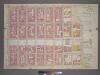
Plate 15, Part of Section 2: [Bounded by Stanton Street, Tompkins Street, Irvington Street, (East River Piers) East Street,Grand Street and Willett Street.]
from Atlas of the city of New York, borough of Manhattan. From actual surveys and official plans / by George W. and Walter S. Bromley.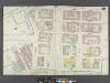
Manhattan, V. 1, Double Page Plate No. 30 [Map bounded by Cannon St., Rivington St., East St., Water St., Corlears St., Jackson St.]
From Atlas 107. Vol. 1, 1894.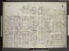
[Plate 31: Map bounded by East Houston Street, Avenue D, Third Street, Tompkins Street, Rivington Street, Willett Street; Including Stanton Street, Sheriff Street, Columbia Street, Manhattan Street, Cannon Street, Lewis Street, Goerck Street
from Insurance maps of the city of New York.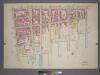
Plate 26, Part of Section 2: [Bounded by Columbia Street, Avenue D, E. 8th Street, Lewis Street, E. 4th Street, (East River Piers) Tompkins Street and Stanton Street.]
from Atlas of the city of New York, borough of Manhattan. From actual surveys and official plans / by George W. and Walter S. Bromley.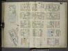
[Plate 30: Map bounded by Cannon Street, Rivington Street, East Street, Cherry Street, Corlears Street, Grand Street; Including Lewis Street, Goerick Street, Mangin Street, Tompkins Street, Monroe Street, Broome Street, Delancy Street, Dela
from Maps of the city of New-York.
Plate 39: Map bounded by Houston Street, Avenue D, 3rd Street, East River, Rivington Street, Willett Street.
from Maps of the city of New York / surveyed under directions of insurance companies of said city.
Plate 31: Map bounded by Houston Street, Avenue D, 3rd Street, East Street, Rivington Street, Willett Street
from Maps of the city of New York.
Plate 30: Map bounded by Rivington Street, East Street, Water Street, Corlears Street, Grand Street, Cannon Street
from Maps of the city of New York.
Plate 19: Map bounded by Rivington Street, East Street, Grand Street, Columbia Street.
from Maps of the city of New York / surveyed under directions of insurance companies of said city.
Manhattan, V. 2, Plate No. 15 [Map bounded by Avenue D, 6th St., Marginal St., E. 3rd St.]
From Atlas 110. Vol. 2, 1903.
Manhattan, V. 2, Plate No. 6 [Map bounded by 2nd St., Columbia St., Rivington St., Pitt St.]
From Atlas 110. Vol. 2, 1903.
Manhattan, V. 2, Plate No. 7 [Map bounded by E. 3rd St., Goerck St., Rivington St., Columbia St.]
From Atlas 110. Vol. 2, 1903.
[Plate 1: Map bounded by North 12th Street, 1st Street, North 5th Street, Wythe Street, North 3rd Street, 1st Street, South 7th Street, East River]
from Maps of the city of Brooklyn
Manhattan, V. 1, Plate No. South piers B [Map of south piers B.]
From Atlas 107. Vol. 1, 1894.
Plate 18: Map bounded by Grand Street, East Street, Water Street, Corlears Street, South Street, Jackson Street.
from Maps of the city of New York / surveyed under directions of insurance companies of said city.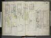
[Plate 34: Map bounded by Avenue D, Eighth Street, East River, Third Street; Including Lewis Street, Mangin Street, East Fourth Street, Fifth Street, Sixth Street, Seventh Street, Eighth Street; Map bounded by Avenue C, Eighth Street, Avenue
from Insurance maps of the city of New York.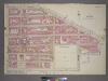
Plate 14, Part of Section 1: [Bounded by East Broadway, Grand Street, East Street, Water Street, Corlears Street, (East River) South Street and Montgomery Street.]
from Atlas of the city of New York, borough of Manhattan. From actual surveys and official plans / by George W. and Walter S. Bromley.
Part of Section 1 : Plate 14.
from Atlas of the borough of Manhattan, city of New York.
Plate 28: Map bounded by Henry Street, Grand Street, Corlears Street, South Street, Montgomery Street
from Maps of the city of New York.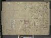
Brooklyn, Vol. 4, Double Page Plate No. 77; [Map bounded by Driggs St. late 5th St., North 6th St., 7th St., 8th St., 9th St., 10th St., 11th St., 12th St., 13th St., 14th St., 15th St., Wythe Ave. late 2nd St.; Including Eckford St., Van Cot
from Insurance maps of the city of Brooklyn L.I.