Maps of Queens County
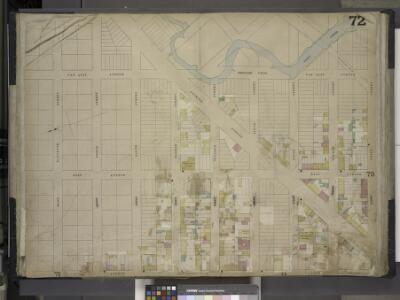
Brooklyn, Vol. 4, Double Page Plate No. 72; [Map bounded by Jacks Creek, East 3rd St., Vernon Ave., East 11th St., East 10th St., East 9th St., East 8th St., East 7th St., East 6th St., East 5th St., East 4th St.; Including East Ave., Van Alst
from Insurance maps of the city of Brooklyn L.I.
Brooklyn, Vol. 4, Double Page Plate No. 71; [Map bounded by Vernon Ave., West 4th St., West 5th St., West 6th St., West 7th St., West 8th St.; Including West Ave.]
from Insurance maps of the city of Brooklyn L.I.
Brooklyn, Vol. 4, Double Page Plate No. 73; [Map bounded by Jacks Creek, Ranton St., Pequod St., Shawnet St., Paidge Ave., Prorost St., Eagle St., Du Pont St., Clay St., Box St.; Including Manhattan Ave. Late Union Place, Ash St., Oakland
from Insurance maps of the city of Brooklyn L.I.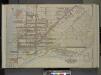
Queens, Vol. 2, Double Page Plate No. 1; Part of Long Island City Ward One (Part of Old Ward One); [Map bounded by Division St., Vernon Ave., 12th St., Ely Ave., Jackson Ave., Thomson Ave., Nott Ave., Creek St., Dutch Kill Creek, Newtown Cree
from First and second wards: Long Island City and Newtown.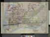
Queens, Vol. 2, Double Page Plate No. 1; Part of Long Island City Ward One (Part of Old Ward 1) Sub Plan; [Map bounded by Pier St., River St., Front St., Newtown Creek.]; Part of Long Island City Ward One (Part of Old Ward 1). [Map bounded by Eas
from Long Island City.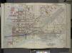
Queens, Vol. 2, Doble Page Plate No. 1; Part of Long Island City Ward One (Part of Old Ward 1); [Map bounded by Divison St., Vernon Ave., 12th St., Ely Ave., Homson Ave., Jackson Ave., Nott Ave., Creek Ave., Dutch Kill Creek, Newtown Creek; In
from First and second wards: Long Island City and Newtown.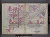
Queens, V. 2, Double Page Plate No. 1; Part of Long Island City, Ward 1; [Map bounded by 12th St., Ashburn St., Newtown Creek, East River] / by and under the supervision of Hugo Ullitz.
From v. 2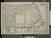
Queens, Vol. 2, Double Page Plate No. 2; Part of Long Island City Ward One (Part of Old Ward 1& 3). [Map bounded by Webster Ave., Freeman Ave., Vernon Ave., Payntar Ave., Beebe Ave., Wilbur Ave., Harris Ave., Jackson Ave., Nott Ave., West Ave.,
from Long Island City.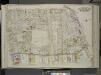
Queens, Vol. 2, Double Page Plate No. 2; Part of Long Island City Ward one (Part of Old Wards 1 and 3); [Map bounded by Prospect St., Harris Ave., Hunter Ave., Jackson Ave., 12th St., Division St., West Ave., 13th St., 14th St., Englis St., Bodine S
from First and second wards: Long Island City and Newtown.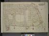
Queens, Vol. 2, Double Page Plate No. 2; Part of Long Island City Ward One (Part of Old Wards One and Three); [Map bounded by Prospect St., Harris Ave., Jackson Ave., 12th St., Vernon Ave., Division St., West Ave., Nott Ave., 13th St., 14th St., Engl
from First and second wards: Long Island City and Newtown.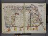
Queens, V. 2, Double Page Plate No. 2; Part of Long Island City, Ward 1; [Map bounded by Prospect St., 12th St., East River, Webster Ave.] / by and under the supervision of Hugo Ullitz.
From v. 2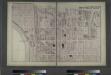
Hunters Point. Part of Long Island City.
from Atlas of Long Island, New York. From recent and actual surveys and records.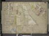
Brooklyn, Vol. 4, Double Page Plate No. 70; [Map bounded by Vernol Ave., Manhattan Ave. late Union Ave., Commercial St., Box St., Bell St. (Not Opened), Newtown Creek, River St.; Including Pier St., Dock St., South St., Flushing St., Front St.,
from Insurance maps of the city of Brooklyn L.I.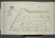
Vol. 6. Plate, D. [Map bound by Whale Creek Canal, Green Point Ave., Oakland St., Newtown Creek; Including Duck St., Brant St., Setauket St., Provost St., Ranton St., Pequod St., Shawnet St., Water St., Paidge Ave., Clay St., Dupont St., Eagle St., Freem
from Detailed estate and old farm line atlas of the city of Brooklyn : complete in six volumes ... from official records, private plans, and actual surveys ... / by G.M. Hopkins, C.E.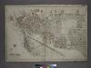
[Plate 1: Bounded by (East River) River Street, Dock Street, Front Street, Hunterspoint Avenue, West Avenue, Vernon Avenue, Freeman Avenue, Jackson Avenue, Thomson Avenue, Upton Street, Mott Avenue, Creek Street, Borden Avenue, Vernon and Flushing Street
from Atlas of the city of New York, borough of Queens, Long Island City, Newtown, Flushing, Jamaica, Far Rockaway, from actual surveys and official plans / by George W. and Walter S. Bromley.
Part of Long Island City, Ward No. 1 & 3.
from Atlas of Queens Co., Long Island, New York / compiled from official records, private plans & actual surveys by and under the direction of Chester Wolverton.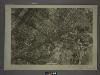
9C - N.Y. City (Aerial Set).
from Sectional aerial maps of the City of New York / [photographed and assembled under the direction of the chief engineer, July 1st, 1924].
Sheet 8: Map encompassing Greenpoint and North Williamsburg.
from Map of the city of Brooklyn : being the former cities of Brooklyn & Williamsburgh and the town of Bushwick, as consolidated January 1st, 1855 by an act of the legislature of the State of New York ... showing also a part of the City of New York.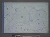
Area District Map Section No. 9; Area district map / City of New York, Board of Estimate and Apportionment.
from Area district map / City of New York, Board of Estimate and Apportionment. New York (N.Y.). Board of Estimate and Apportionment,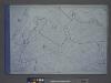
Height District Map Section No. 9; Height district map / City of New York, Board of Estimate and Apportionment.
from Height district map / City of New York, Board of Estimate and Apportionment. New York (N.Y.). Board of Estimate and Apportionment,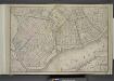
Brooklyn, Double Page Section 1; [Including wards 13, 14, 15, 16, 17, 18, 19]
from Farm line map of the city of Brooklyn, from official records and surveys; comp. and drawn by Henry Fulton.
Plan of the city of Brooklyn, L.I. / by William Perris.
from Brooklyn
A new map of the city of New York : comprising all the late improvements, compiled and corrected from authentic documents, designed to accompany the Description of New York.
from Manhattan
Topographical Atlas Of The City Of New York
1 : 12000 Viele, Egbert L.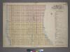
Outline & Index Map of Volume Two, Atlas of New York City, 14th Street to 59th Street.
from Atlas of the city of New York, borough of Manhattan. From actual surveys and official plans / by George W. and Walter S. Bromley.
Outline and Index Map of Atlas of New York City.
from Atlas of the borough of Manhattan, city of New York.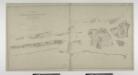
Blackwell's, Ward's and Randall's islands and adjacent shores of East and Harlem Rivers : from 51st St. New York to Lawrence's Pt. / U.S. Coast and Geodetic Survey, F.M. Thorn, superintendent ; surveyed by E. Hergesheimer, assistant, 1885.
from New York harbor
Use District Map Section No. 9
from Use district map / City of New York, Board of Estimate and Apportionment.
City of New-York / W. Kemble.
from Manhattan