Maps of Hoboken
New map of that part of the city of New York south from 20th Street on the Hudson & 35th Street on the East River : showing the position of Greenwich, Washington and West Streets on the Hudson River, and Pearl, Water, Front, Cherry & Tompkins Sts. on the
from Manhattan
A new map of the city of New York : comprising all the late improvements, compiled and corrected from authentic documents.
from Manhattan
A new map of the city of New York : comprising all the late improvements, compiled and corrected from authentic documents, designed to accompany the Description of New York.
from Manhattan
A new map of the city of New York : comprising all the late improvements, compiled and corrected from authentic documents.
from Manhattan
City of New-York
1 : 12500 Burr, David H., 1803-1875 Edward Walker
City of New-York.
1 : 17000 Mitchell, Samuel Augustus
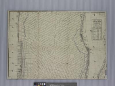
Part of the 23rd Ward, New York City.
from Atlas of the city of New York : from official records, private plans & actual surveys / compiled under the supervision of E. Robinson & R. H. Pidgeon.
Plan von der Stadt New York
1 : 68500 New York (New York)
Topographical Atlas Of The City Of New York
1 : 12000 Viele, Egbert L.
Map of the city of New York.
from Manhattan
Hooker's new pocket plan of the city of New York / compiled & surveyed by William Hooker, engraver, No. 179 Water Street, New York, house, Willoughby St., Brooklyn.
From Manhattan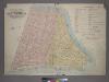
Outline & Index Map of Volume One, Atlas of New York City, Borough of Manhattan: Battery to Fourteenth Street.
from Atlas of the city of New York, borough of Manhattan. From actual surveys and official plans / by George W. and Walter S. Bromley.
Plan of the city of New-York : the greater part from actual survey made expressly for the purpose (the rest from authentic documents)
1 : 7300 Poppleton, Thomas H Prior & Dunning
Key
From Atlas 110. Vol. 2, 1903.
City of New York, 1843.
from The cerographic atlas of the United States. By Sidney E. Morse, A.M., and Samuel Breese, A.M.
"Where all the Village meet to eat" - An accurate and detailed map of Greenwich Village and Environment.
From Manhattan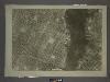
12B - N.Y. City (Aerial Set).
from Sectional aerial maps of the City of New York / [photographed and assembled under the direction of the chief engineer, July 1st, 1924].
Plan of the city of New-York : with the recent and intended improvements / drawn from actual survey by William Bridges, city surveyor, A.D. 1807 ; engraved by Peter Maverick.
from Manhattan
Plan von der Stadt New-York.
from Manhattan
Plan von New-York
Grosser Hand-Atlas über alle Theile der Erde in 170 Karten Meyer, J. Verlag des Bibliographischen Instituts
Plan of the city of New-York : the greater part from actual survey made expressly for the purpose (the rest from authentic documents) / by Thos. H. Poppleton, city surveyor ; P. Maverick sc. Newark.
from Manhattan
Block distribution of children of 4 to 18 years of age for Chelsea and Greenwich for 1910.
From Manhattan
The city of New York drawn from actual surveys as furnished by the several city surveyors
1 : 2350 [s.n.]
Plan of the city of New-York : the greater part from actual survey made expressly for the purpose (the rest from authentic documents) / by Thos. H. Poppleton, city surveyor ; P. Maverick sc. Newark.
from Manhattan
Plan of the city of New-York / drawn from actual survey by C[a]simir Th. [G]oerck, and Joseph Fr. Mangin, city surveyors.
from Manhattan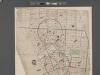
[Map of New York City between Canal and 22nd Sts?? and Broadway and the Hudson River School District No. 9, showing population and school attendance figures.]
From Manhattan
Map showing the old high water lines along the shores of Brooklyn & New York together the the pier lines as established by law.
From Manhattan
Map showing the old high water lines along the shores of Brooklyn & New York together the the pier lines as established by law.
From Manhattan
Map of the city of New-York extending northward to Fiftieth St. / surveyed and drawn by John F. Harrison, C.E.
from Manhattan