Maps of Queens County
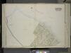
Queens, Vol. 2, Double Page Plate No. 20; Part of Ward two Newtown; [Map bounded by Flushing Bay, Bay Shore Terrace, Harbour PL.; Including Sound View PL., Astoria and Flushing Turnpike, Old Bowery Road, Jackson's Creek]
from First and second wards: Long Island City and Newtown.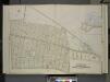
Queens, Vol. 2, Double Page Plate No. 16; Part of Ward Two Corona and Louona Park; [Map bounded by Old Bowery Road, Flushing and Astoria Road, Coddington PL.; Including Park Ave., Lent St., Flushing Turnpike, Junction Ave.]; Sub Plan; [Map boun
from First and second wards: Long Island City and Newtown.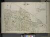
Queens, Vol. 2, Double Page Plate No. 22; Part of Ward Two Corona and Louona Park; [Map bounded by Bowery Road, Old Bowery Road, Flushing and Astoria Road, Jackson Ave., Coddington PL.; Including Park Ave., Flushing and Newtown Turnpike, Lent
from First and second wards: Long Island City and Newtown.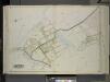
Queens, Vol. 2, Double Page Plate No. 19; Part of Ward two North Beach; [Map bounded by Flushing Bay, Beach St., Jackson Creek, Old Bowery Road, Astoria and Flushing Turnpike; Including Bowery Bay, Grand Boulevard, Sandford Point Ave.]
from First and second wards: Long Island City and Newtown.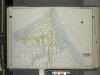
Queens, Vol. 2A, Double Page Plate No. 5; Part of Ward Two Newtown. [Map bounded by Bowery Bay, Flushing Bay; Including Mansfield Ave., 28th St.] / by and under the supervision of Hugo Ullitz.
From v. 2A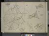
Queens, Vol. 2, Double Page Plate No. 30; Part of Ward Two Newtown, Trains Meadow, Wood Side and Elmhurst; [Map bounded by Bowery Bay, Flushing Bay, Corona, Junction Ave.; Including Elmhors Ave., Astoria and Flushing Turnpike, Woodside Ave., J
from First and second wards: Long Island City and Newtown.
Area District Map Section No. 10
from Area district map / City of New York, Board of Estimate and Apportionment.
Key Continued
From Atlas 148, Vol. 10, 1914.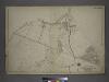
[Plate 17: Bounded by Bowery Bay Road, Shore Road, N. Beach Avenue, Maple Avenue, Old Bowery Road (Flushing Bay), Junction Avenue, Jackson Avenue, Trains Meadow Road and (St. Michaels Cemetery) Astoria and Flushing Turnpike.]
from Atlas of the city of New York, borough of Queens, Long Island City, Newtown, Flushing, Jamaica, Far Rockaway, from actual surveys and official plans / by George W. and Walter S. Bromley.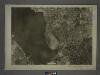
10A - N.Y. City (Aerial Set).
from Sectional aerial maps of the City of New York / [photographed and assembled under the direction of the chief engineer, July 1st, 1924].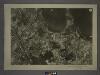
9B - N.Y. City (Aerial Set).
from Sectional aerial maps of the City of New York / [photographed and assembled under the direction of the chief engineer, July 1st, 1924].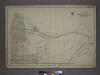
Part of the Borough of Queens, New town, Ward 2.
from Atlas of the city of New York, borough of Queens, Long Island City, Newtown, Flushing, Jamaica, Far Rockaway, from actual surveys and official plans / by George W. and Walter S. Bromley.
Height District Map Section No. 10; Height district map / City of New York, Board of Estimate and Apportionment.
from Height district map / City of New York, Board of Estimate and Apportionment. New York (N.Y.). Board of Estimate and Apportionment,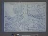
Use District Map Section No. 10; Use district map / City of New York, Board of Estimate and Apportionment.
from Use district map / City of New York, Board of Estimate and Apportionment. New York (N.Y.). Board of Estimate and Apportionment,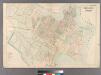
College Point.
from Atlas of Queens Co., Long Island, New York / compiled from official records, private plans & actual surveys by and under the direction of Chester Wolverton.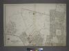
Part of the Borough of Queens, New town, Ward 2.
from Atlas of the city of New York, borough of Queens, Long Island City, Newtown, Flushing, Jamaica, Far Rockaway, from actual surveys and official plans / by George W. and Walter S. Bromley.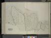
Queens, Vol. 2, Double Page Plate No. 49; Part of Ward Two Newtown; [Map bounded by Flushing Bay, Flushing Creek, Mill Creek, Corona Hempstead Plank Road, Longview St., Fairview St., Home St., Orchard St.; Including Smith St., Plateau St., M
from First and second wards: Long Island City and Newtown.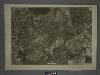
10C - N.Y. City (Aerial Set).
from Sectional aerial maps of the City of New York / [photographed and assembled under the direction of the chief engineer, July 1st, 1924].
9D - N.Y. City (Aerial Set).
from Sectional aerial maps of the City of New York / [photographed and assembled under the direction of the chief engineer, July 1st, 1924].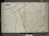
Queens, Vol. 2, Double Page Plate No. 21; Sub Plan No. 1; [Map bounded by Flushing and Newtown Road; Including Junction Ave.]; Part of Ward Two Newtown; [Old Bowery Road, Old Junction Ave., Flushing and Newtown Road, 12th St., Whitney Ave., 11th
from First and second wards: Long Island City and Newtown.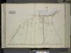
Queens, Vol. 2, Double Page Plate No. 13; Part of Ward Two Newtown; [Map bounded by Long Island City, Cabinet St., Bowery Bay Road, Shore Road; Including Old Bowery Bay Road, Kouvenhoven Ave., Astoria and Flushing Turnpike]
from First and second wards: Long Island City and Newtown.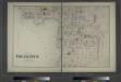
Part of College Point. Town of Flushing, Queens Co.
from Atlas of Long Island, New York. From recent and actual surveys and records.
Jackson Heights, North Corona, East Elmhurst. (cont.)
From District 3
Key Continued
From Atlas 141. Vol. 5, 1903.
Map of Flushing published by the Flushing United Association. List of references to public buildings.
From Queens
Key Continued
From Atlas 137. Vol. 3, 1902.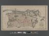
[Long Island City, Queens] Record of searches in relation to the legal status of avenues and streets in the 1st Ward of the Borough of Queens.
From Queens
Upper West Side, Yorkville, Lenox Hill, Welfare Island. (cont.)
From District 8
Map of the Harlem River and Spuyten Duyvil Creek from Ward's Island to the Hudson River, showing project for a covered waterway 60 feet wide to be built on the west line of the Harlem River from the easterly side of Third Avenue to 165th street, New Y...
From Manhattan
![Queens, Vol. 2, Double Page Plate No. 20; Part of Ward two Newtown; [Map bounded by Flushing Bay, Bay Shore Terrace, Harbour PL.; Including Sound View PL., Astoria and Flushing Turnpike, Old Bowery Road, Jackson's Creek]](https://images-2.georeferencer.com/images/iiif/386486781665/full/,300/0/native.jpg)

