Maps of Queens County
Queens, Vol. 1, Double Page Plate No. 11; Sub Plan; Formerly Town of Flushing 3rd Ward; [Map bounded by Grand Ave., Black Stump Road, Charlecote, Croydon Jamaica Estates Road, Edgerton Blvd., Doncaster Blvd., Henley Road, Midland Parkway, Radno
from Fourth and fifth wards: Jamaica and Rockaway.
Queens, Vol. 1A, Double Page Plate No. 2; Part of Ward 4 Jamaica. [Map bounded by Jamaica Ave., 175th St., 90th Rd., 179th PL., 181st PL.; Including 181st St., 108th Ave., New York Ave.] / by and under the supervision of Hugo Ullitz.
From v. 1A
Map of Jamaica Hillcrest, sections C and D, property of the Jamaica Hillcrest Company in the Borough of Queens.
From Queens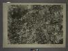
14D - N.Y. City (Aerial Set).
from Sectional aerial maps of the City of New York / [photographed and assembled under the direction of the chief engineer, July 1st, 1924].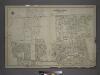
Part of the Borough of Queens, Jamaica, Ward 4.
from Atlas of the city of New York, borough of Queens, Long Island City, Newtown, Flushing, Jamaica, Far Rockaway, from actual surveys and official plans / by George W. and Walter S. Bromley.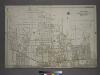
Part of the Borough of Queens, Jamaica, Ward 4.
from Atlas of the city of New York, borough of Queens, Long Island City, Newtown, Flushing, Jamaica, Far Rockaway, from actual surveys and official plans / by George W. and Walter S. Bromley.
Jamaica Village. Queens Co. L.I. [From Highland Avenue to Atlantic Avenue, and from Myrtle Avenue to Franklin Avenue.]
from Atlas of Long Island, New York. From recent and actual surveys and records.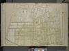
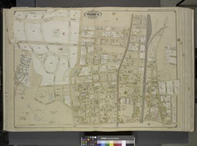
Queens, Vol. 1, Double Page Plate No. 9; Sub Plan;[Map bounded by Flushing Ave., Grand Ave., Briarwood Road; Including Alsop St., Lake St., Orchard St., Hutton PL.]; Part of Ward 4, Jamaica; [Map bounded by Terrace Ave., Ocean View Ave., K
from Fourth and fifth wards: Jamaica and Rockaway.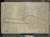
Queens, Vol. 1, Double Page Plate No. 12; Part of Ward 4; Jamaica; [Map bounded by Foothill Ave., Hillside Ave., Columbus Ave., Lincoln Ave., Grant Ave., Max Weber Ave., Cozine Ave., Belleview Ave., Prospect Ave., Park Ave., Colton Ave., Eden
from Fourth and fifth wards: Jamaica and Rockaway.
Queens, Vol. 1, Double Page Plate No. 10; Part of Ward 4, Jamaica; [Map bounded by New York Ave., Brooklyn Ave., Globe Ave., Rail Road Ave., Norris Ave., Brown Ave., Phraner Ave., Dubroff Ave., O' Donnell Ave., Russell Ave., Woodlawn Ave.; Includ
from Fourth and fifth wards: Jamaica and Rockaway.
Key Continued
From Atlas 139. Vol. 4, 1901.
Kew Gardens Hills, Utopia, Fresh Meadows, Hillcrest, Briarwood, Jamaica Hills. (cont.)
From District 8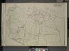
Queens, Vol. 3, Double Page Plate No. 19; Part of ward Three Flushing; [Map bounded by Strongs Causeway Ireland, Mill Road, North Hempstead Turnpike, Crop Road, Union Ave., Hoffman Ave., Boundary Line of Flushing, Jamaica, Head of the Vlei
from Third ward: Flushing.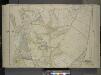
Queens, Vol. 1, Double Page Plate No. 18; Part of Ward 4; Jamaica; [Map bounded by South St., Country Road, Old Country Road, Jamaica Plank Road; Including Boundary Line Of City Of New York, Ocean Ave., Farmers Ave., Rockaway Turnpike, Th
from Fourth and fifth wards: Jamaica and Rockaway.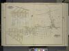
Queens, Vol. 1, Double Page Plate No. 14; Sub Plan No. 1; [Map Bounded by Hempstead and Jamaica Plank Road, Howard Ave., Clifford Ave., Silveira PL., Elderd PL., Hollis Ave., Atlantic Ave., West Point Ave., Nyack Ave., Webster Ave., Olster Av
from Fourth and fifth wards: Jamaica and Rockaway.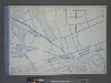
Use District Map Section No. 14; Use district map / City of New York, Board of Estimate and Apportionment.
from Use district map / City of New York, Board of Estimate and Apportionment. New York (N.Y.). Board of Estimate and Apportionment,
Height District Map Section No. 14; Height district map / City of New York, Board of Estimate and Apportionment.
from Height district map / City of New York, Board of Estimate and Apportionment. New York (N.Y.). Board of Estimate and Apportionment,
Area District Map Section No. 14; Area district map / City of New York, Board of Estimate and Apportionment.
from Area district map / City of New York, Board of Estimate and Apportionment. New York (N.Y.). Board of Estimate and Apportionment,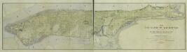
1609. The island of Manhattan (Mannahtin) at the time of its discovery showing its elevations, water-courses, marshes, and shore line. / [cartographic material]
From Early New York history, portrayed in five maps
Map of the Village of Jamaica, Queens Co., Long Island [plat map].
From Queens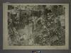
14B - N.Y. City (Aerial Set).
from Sectional aerial maps of the City of New York / [photographed and assembled under the direction of the chief engineer, July 1st, 1924].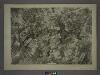
15C - N.Y. City (Aerial Set).
from Sectional aerial maps of the City of New York / [photographed and assembled under the direction of the chief engineer, July 1st, 1924].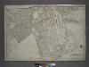
Part of the Borough of Queens, Jamaica, Ward 4.
from Atlas of the city of New York, borough of Queens, Long Island City, Newtown, Flushing, Jamaica, Far Rockaway, from actual surveys and official plans / by George W. and Walter S. Bromley.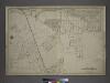
Part of the Borough of Queens, Jamaica, Ward 4.
from Atlas of the city of New York, borough of Queens, Long Island City, Newtown, Flushing, Jamaica, Far Rockaway, from actual surveys and official plans / by George W. and Walter S. Bromley.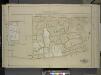
Queens, Vol. 1, Double Page Plate No. 13; Part of Ward 4 Jamaica; (Formerly Town of Flushing 3rd Ward.); [Map bounded by Pueblo Ave., Mc. Laughlin , Flushing Road, Boulevard, Epsom Course, Palermo Ave., Santiago Ave., Cato Ave., Palo Alto
from Fourth and fifth wards: Jamaica and Rockaway.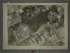
15A - N.Y. City (Aerial Set).
from Sectional aerial maps of the City of New York / [photographed and assembled under the direction of the chief engineer, July 1st, 1924].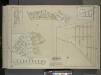
Queens, Vol. 1, Double Page Plate No. 29; Part of Ward 4; Jamaica; Sub Plan; [Map bounded by Merrick Road, Cumberland St., Carmen PL., Highview PL., Highview Ave., South St.; Including Merrick Plank Road, Hobson St., Dewey Ave., Samuel St.,
from Fourth and fifth wards: Jamaica and Rockaway.
Queens V. 4, Plate No. 63 [Map bounded by Highland Ave., Herriman Ave., Shelton Ave., Ray]
From Atlas 139. Vol. 4, 1901.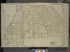
Queens, Vol. 1, Double Page Plate No. 7; Part of Ward 4, Jamaica; [Map bounded by Rockaway Turnpike, Vanderbilt Ave., Foley Ave., Campion Ave., Rose Ave., Mc.Auley Ave., Van Wyck Ave., Lester Ave., Agnolia Ave., Johnson Ave., Chichester Ave.
from Fourth and fifth wards: Jamaica and Rockaway.